Firth is a word in the English and Scots languages used to denote various coastal waters in the United Kingdom, predominantly within Scotland. In the Northern Isles, it more often refers to a smaller inlet. It is linguistically cognate to fjord, which has a more constrained sense in English. Bodies of water named "firths" tend to be more common on the Scottish east coast, or in the southwest of the country, although the Firth of Clyde is an exception to this. The Highland coast contains numerous estuaries, straits, and inlets of a similar kind, but not called "firth" ; instead, these are often called sea lochs. Before about 1850, the spelling "Frith" was more common.

Stonehaven is a town in Scotland. It lies on Scotland's northeast coast and had a population of 11,602 at the 2011 Census. After the demise of the town of Kincardine, which was gradually abandoned after the destruction of its royal castle in the Wars of Independence, the Scottish Parliament made Stonehaven the successor county town of Kincardineshire. It is currently administered as part of the Aberdeenshire Council Area. Stonehaven had grown around an Iron Age fishing village, now the "Auld Toon", and expanded inland from the seaside. As late as the 16th century, old maps indicate the town was called Stonehyve, Stonehive, Timothy Pont also adding the alternative Duniness. It is known informally to locals as Stoney.

Flamborough Head is a promontory, 8 miles (13 km) long on the Yorkshire coast of England, between the Filey and Bridlington bays of the North Sea. It is a chalk headland, with sheer white cliffs. The cliff top has two standing lighthouse towers, the oldest dating from 1669 and Flamborough Head Lighthouse built in 1806. The older lighthouse was designated a Grade II* listed building in 1952 and is now recorded in the National Heritage List for England, maintained by Historic England. The cliffs provide nesting sites for many thousands of seabirds, and are of international significance for their geology.

Kincardineshire or the County of Kincardine, also known as the Mearns, is a historic county, registration county and lieutenancy area on the coast of northeast Scotland. It is bounded by Aberdeenshire on the north and west, and by Angus on the south.

Dunnet Head is a headland in Highland, on the north coast of Scotland. Dunnet Head includes the most northerly point of both mainland Scotland and the island of Great Britain.
Thurso Bay, known also as Scrabster Bay, is a bay of Atlantic water between the points of Clairdon Head and Holborn Head on the north coast of Caithness, Scotland.
Holborn Head is a headland on the north-facing Atlantic coast of Caithness, in the Highland area of Scotland. The point of Holborn Head is at 58°37′23″N03°32′06″W. It has a lighthouse at its south end and the remains of an old fort at its tip.
Rame Head or Ram Head is a coastal headland, southwest of the village of Rame in southeast Cornwall, England, United Kingdom. It is part of the larger Rame Peninsula.
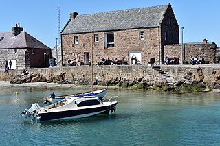
The Stonehaven Tolbooth is a late 16th-century stone building originally used as a courthouse and a prison in the town of Stonehaven, Aberdeenshire, Scotland. Constructed of local Old Red Sandstone, the prison probably attained its greatest note, when three local Episcopalian clergymen were imprisoned for holding services for more than nine people. Lying midway along the old north quay of the Stonehaven Harbour, the present day Tolbooth serves as a local museum with a restaurant on the floor above the ground floor. It is a category A listed building.
Carron Water is a river in Kincardineshire, Aberdeenshire, Scotland.

Muchalls is a small coastal ex-fishing village in Kincardineshire, Scotland, south of Newtonhill and north of Stonehaven. Muchalls is situated slightly north of a smaller hamlet known as the Bridge of Muchalls. At the western edge of Muchalls is the historic Saint Ternan's Church. The rugged North Sea coastline near Muchalls features numerous cliffs, sea stacks and headlands, not infrequently in haar. The Grim Brigs headland is situated at Muchalls southern edge and Doonie Point headland is approximately 1.5 kilometres south.

Doonie Point is a rocky headland situated approximately 1.5 kilometres south of the village of Muchalls in Aberdeenshire, Scotland. The clifftop of Doonie Point yields views to the north of Grim Brigs, Brown Jewel and the coast of Newtonhill. To the south are views of the Castle Rock of Muchalls and the rugged North Sea coastline toward Stonehaven. Notable historic structures in the vicinity of Doonie Point are the Chapel of St. Mary and St. Nathalan, Muchalls Castle and the Mill of Muchalls. This site is a recognised rock climbing venue. Doonie Point is catalogued within the marine rescue activities for this part of the coast of northeast Scotland.

Bowdun Head is a headland landform on the North Sea coast approximately one kilometre south of Stonehaven, Scotland.(Ordnance Survey, 2004) Slightly to the north is another headland, Downie Point. Somewhat to the south along the coast is Dunnottar Castle on the far side of the bay of Castle Haven. Other historic structures in the general vicinity include the Stonehaven Tolbooth, Fetteresso Castle, the Chapel of St. Mary and St. Nathalan and Muchalls Castle. There is considerable prehistory associated with the local area including a Pictish hill fort on the sea stack of Dunnicaer immediately to the north, and Bronze Age archaeological sites at Fetteresso and Spurryhillock, both somewhat inland of Bowdun Head.

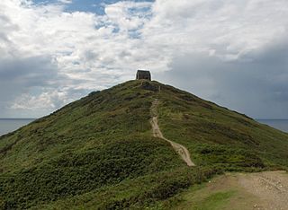
Downie Point is a prominent headland located at the southern edge of Stonehaven Bay in Aberdeenshire, Scotland. From the Stonehaven Harbour, there is a panoramic view of this cliff landform, especially from the tip of Bellman's Head.
Milton Ness is a coastal landform along the coast of the North Sea approximately two miles south of the village of Johnshaven, Scotland. This headland feature includes a red sandstone cliff formation. Certain prehistoric features are found in the vicinity of Milton Ness, including the Stone of Morphie located somewhat to the west.

Hare Ness is a headland landform along the North Sea coastline a few miles south of Aberdeen, Scotland.
A headland, also known as a head, is a coastal landform, a point of land usually high and often with a sheer drop, that extends into a body of water. It is a type of promontory. A headland of considerable size often is called a cape. Headlands are characterised by high, breaking waves, rocky shores, intense erosion, and steep sea cliff.
Strathlethan Bay is on the North Sea coast of Aberdeenshire, Scotland just south of Stonehaven. To the north is Downie Point near which lies Stonehaven's Black Hill war memorial – the popular walk from Stonehaven to Dunnottar Castle runs along this part of the trail. On the other side of the bay is Dunnicaer, an inaccessible sea stack just offshore of Bowdun Head. The long-distance Aberdeenshire Coastal Trail runs around the bay at the top of steep cliffs. On 19 November 1916 the wreckage of the Norwegian steamer Isa Fiord was washed ashore in the bay and on 8 October 1940 the Danish ship Bellona II came aground after it had suffered bombing damage off Gourdon.

Stonehaven Town Hall is a municipal building in Allardice Street, Stonehaven, Aberdeenshire, Scotland. The building, which is largely used as an events venue, is a Category B listed building.
