Related Research Articles
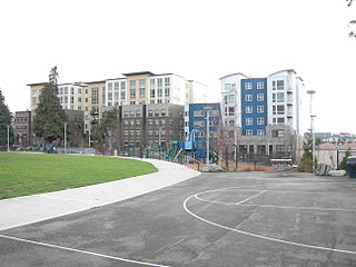
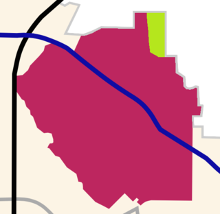
Cascade is an urban neighborhood abutting Downtown Seattle, Washington, United States, located adjacent to South Lake Union. It is bounded by: Fairview Avenue North on the west, beyond which is the rest of the Cascade Neighborhood; the Interstate 5 interchange for Mercer St to the north, beyond which is Eastlake; Interstate 5 on the east, beyond which is Capitol Hill; and Denny Way on the south, beyond which is Denny Triangle. It is surrounded by thoroughfares Mercer Street (eastbound), Fairview Avenue N. and Eastlake Avenue E., and Denny Way. The neighborhood, one of Seattle's oldest, originally extended much further: west to Terry Avenue, south to Denny Hill on the South, and east to Melrose Avenue E through the area now obliterated by Interstate 5. Some recent writers consider Cascade to omit the northern "arm", while others extend it westward to cover most of South Lake Union.

Irving Park is one of 77 officially designated Chicago community areas, and is located on the Northwest Side. It is bounded by the Chicago River on the east, the Milwaukee Road railroad tracks on the west, Addison Street on the south and Montrose Avenue on the north, west of Pulaski Road stretching to encompass the region between Belmont Avenue on the south and, roughly, Leland Avenue on the north. It is named after the American author Washington Irving.
Kirkwood is a national historic designated neighborhood on the east side of Atlanta, Georgia, United States. It is a historic streetcar suburb situated entirely in DeKalb County, bordered by the neighborhoods of Lake Claire, East Lake, Edgewood, and Oakhurst. Kirkwood is bound on the north by DeKalb Avenue, on the south by Memorial Drive and Interstate 20, on the west by Montgomery Street, and on the east by 1st Ave. A large part of the neighborhood is listed on the National Register of Historic Places as Kirkwood Historic District.
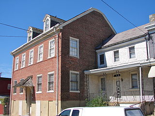
Frankford is a neighborhood in the Northeast section of Philadelphia situated about six miles (10 km) northeast of Center City. Although its borders are vaguely defined, the neighborhood is bounded roughly by the original course of Frankford Creek on the south to Castor Avenue on the northwest and southwest, to Cheltenham Avenue on the north, and to Aramingo Avenue and I-95 on the east. [source: GoogleMaps] Adjacent neighborhoods are Bridesburg, Juniata, Northwood, Summerdale, and Wissinoming.

Lake Highlands is a neighborhood constituting most of Northeast Dallas. The neighborhood is a collection of dozens of subdivisions served by Richardson ISD and Dallas ISD public schools, as well as an array of private schools.
Vickery Place is a historic neighborhood in East Dallas, Texas, bounded on the north by Goodwin Avenue, on the west by North Central Expressway and Henderson, on the south by Belmont, and on the east by Greenville Avenue. Although Vickery Place is considered by some to be part of the M Streets area, it is strictly speaking not as it is south of the Greenland Hills subdivision. Vickery Place has seen much improvement and property value growth over the past several years due to its close proximity to Downtown Dallas and Uptown, and its location bordering the vibrant Lower Greenville Avenue and Knox-Henderson entertainment and shopping districts.
Bryan Place is a neighborhood in Old East Dallas, Texas (USA). It is east of the Arts District of downtown and the State Thomas neighborhood, north of Deep Ellum, south of Cityplace and west of Munger Place. Its boundaries are generally considered to be US-75 North Central Expressway on the west, Ross Avenue on the (north)west, N. Washington Street on the (north)east, and Live Oak Avenue on the (south)east.

The Swiss Avenue Historic District is a residential neighborhood in East Dallas, Dallas, Texas (USA). It consists of installations of the Munger Place addition, one of East Dallas' early subdivisions. The Swiss Avenue Historic District is a historic district of the city of Dallas, Texas. The boundaries of the district comprise both sides of Swiss Avenue from Fitzhugh Street, to just north of La Vista, and includes portions of Bryan Parkway. The District includes the 6100-6200 blocks of La Vista Drive, the west side of the 5500 block of Bryan Parkway the 6100-6300 blocks of Bryan Parkway, the east side of the 5200-5300 block of Live Oak Street, and the 4900-6100 blocks of Swiss Avenue. The entire street of Swiss Avenue is not included within the bounds of the Swiss Avenue Historic District. Portions of the street run through Dallas' Peaks Suburban Addition neighborhood and Peak's Suburban Addition Historic District. 5215 Swiss was built in 1914 and was the home of J. P. Cranfield
Lower Greenville is a neighborhood in east Dallas, Texas (USA), west of Lakewood. Specifically, the neighborhood is the area adjacent to Greenville Avenue south of Mercedes Avenue and north of Belmont Avenue. The area south of Belmont Avenue is often, and more specifically, called "Lowest Greenville," and the area north of Mockingbird Lane is called "Upper Greenville." "Lower Greenville" is also used to refer to the neighborhoods surrounding Greenville Avenue, including Vickery Place, the Belmont Addition, Glencoe, Greenland Hills, and Stonewall Terrace. It straddles Dallas Council Districts 14 and 2.
Greenland Hills is a neighborhood in east Dallas, Texas (USA). It is bounded on the west by North Central Expressway, on the south by Vanderbilt Avenue, on the east by Greenville Avenue and on the north by McCommas Boulevard.

Woodland Normanstone is a small, residential neighborhood in Northwest Washington, D.C., adjoining the larger neighborhoods of Woodley Park, Massachusetts Avenue Heights, and Observatory Circle.

Westview is a historic intown neighborhood located in southwest Atlanta, Georgia. It is named for the Westview Cemetery that borders the neighborhood to the northwest. The neighborhood is made up of a mixture of architectural styles including Arts & Crafts bungalows, Four-Squares, Tudors, Minimal Traditional houses, and Ranch style houses.

Packer Park is a neighborhood in the South Philadelphia section of Philadelphia, Pennsylvania, United States that originally included 1,000 homes built in two unique builder developments, of Packer Park in the 1950s and Brinton Estates during the 1990s. It is now one of four residential communities to be designated as Packer Park. The original footprint community is also one of four adjacent communities that form Philadelphia's Sports Complex Special Services District. The approximate boundaries are Packer Avenue to the north, Hartranft Street to the south including FDR Park farther south, Broad Street to the east known as the Southern Parkway, and I-76 to the far west. Packer Park has been considered home to one of the most organized community groups in the South Philadelphia region.

College Hill is a neighborhood of the City of St. Louis, Missouri. The name College Hill was given to this area because it was the location of the Saint Louis University College Farm. This area, bounded generally by Warne Ave., O'Fallon Park, I-70, Grand Boulevard, and W. Florissant Ave., was acquired by the University for garden and recreation purposes in 1836. It was subdivided in the early 1870s.
Glennwood Estates is a historic neighborhood located in the northeast section of Decatur, Georgia. It is a residential neighborhood chiefly of single-family homes including a nature preserve and an adjoining park. At least a third of the homes were built in the 1920s and were relatively large for the time. Glenn Creek and the South Fork of Peachtree Creek Tributary run through the neighborhood.
Prospect Park is a residential neighborhood in Pasadena, California. It is bordered by Westgate Street to the north, Orange Grove Boulevard to the south, Rosemont Avenue to the west, and Lincoln Avenue to the east.
East Dallas, also referred to by the East Dallas Chamber of Commerce as the Lake & Garden District, is an expansive area of numerous communities and neighborhoods in Dallas, Texas, United States that border nearby suburban cities to the east such as Garland, Mesquite and Balch Springs.
Parkers Woods and Buttercup Valley Nature Preserve
Whispering Hills is a neighborhood consisting of 615 homes within the Lake Highlands neighborhood of Dallas, Texas adjacent to the suburbs of Richardson and Garland. It is generally bounded by Buckingham Rd along the Richardson border to the north, to the east by the Garland border near Plano Rd, to the south by Walnut St, and to the west by the KCS Railroad and Audelia Branch Greenbelt near Audelia Rd.
Lakewood Heights is a residential neighborhood in Dallas, Texas (USA), bounded by Abrams Road to the east, Monticello Avenue to the north, Skillman Street to the west, and Richmond Avenue to the south. It located in East Dallas. Lakewood Heights is approximately one-half mile (0.8 km) wide (east-west) and three-quarters of a mile (1.2 km) long (north-south). It covers approximately 240 acres or slightly less than 0.375 square miles (1000m²). It is adjacent to several East Dallas neighborhoods, including Lakewood, Lower Greenville, and Wilshire Heights.
References
- ↑ Neighborhood, Belmont (2020-09-14). "Overview". Belmont Conservation District. Retrieved 2020-09-14.