Belo sur Mer

Last updated
Belo sur Mer

Rue principale de Belo sur Mer - Madagascar.jpg

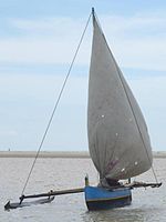
main road of Belo sur Mer
Madagascar location map.svg
Red pog.svg
Belo sur Mer
Location in Madagascar
Coordinates: 20°44′S44°0′E / 20.733°S 44.000°E / -20.733; 44.000
CountryFlag of Madagascar.svg  Madagascar
Region Menabe
District Morondava
Elevation [1] 5 m (16 ft)
Population (2001) [2]
  Total 8,000
Time zone EAT (UTC3)

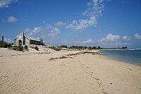
Belo sur Mer is a town and commune (Malagasy : kaominina) in Madagascar. It belongs to the district of Morondava, which is a part of Menabe Region. The population of the commune was estimated to be approximately 8,000 in 2001 commune census. [2]

Malagasy is an Austronesian language and the national language of Madagascar. Most people in Madagascar speak it as a first language as do some people of Malagasy descent elsewhere.

Madagascar island nation off the coast of Southeast Africa, in the Indian Ocean

Madagascar, officially the Republic of Madagascar, and previously known as the Malagasy Republic, is an island country in the Indian Ocean, approximately 400 kilometres off the coast of East Africa. The nation comprises the island of Madagascar and numerous smaller peripheral islands. Following the prehistoric breakup of the supercontinent Gondwana, Madagascar split from the Indian subcontinent around 88 million years ago, allowing native plants and animals to evolve in relative isolation. Consequently, Madagascar is a biodiversity hotspot; over 90% of its wildlife is found nowhere else on Earth. The island's diverse ecosystems and unique wildlife are threatened by the encroachment of the rapidly growing human population and other environmental threats.

Districts of Madagascar

Districts are second-level administrative divisions of Madagascar below the regions. There are 114 districts in Madagascar. Districts are in their turn divided into communes; while some of the districts in urban areas and offshore islands each consist of only one commune, most of the districts are divided typically into 5–20 communes.

Contents

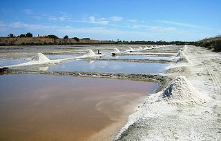
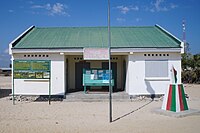
Primary and junior level secondary education are available in town. It is also a site of industrial-scale mining. The majority 60% of the population of the commune are farmers. The most important crop is maize, while other important products are sweet potatoes and lima beans. Industry provides employment for 10% of the population. Additionally fishing employs 30% of the population. [2]

Maize Cereal grain

Maize, also known as corn, is a cereal grain first domesticated by indigenous peoples in southern Mexico about 10,000 years ago. The leafy stalk of the plant produces pollen inflorescences and separate ovuliferous inflorescences called ears that yield kernels or seeds, which are fruits.

Sweet potato species of plant

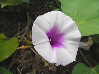
The sweet potato is a dicotyledonous plant that belongs to the bindweed or morning glory family, Convolvulaceae. Its large, starchy, sweet-tasting, tuberous roots are a root vegetable. The young leaves and shoots are sometimes eaten as greens. The sweet potato is only distantly related to the potato and does not belong to the nightshade family, Solanaceae, but both families belong to the same taxonomic order, the Solanales.

Lima bean species of plant

Phaseolus lunatus, commonly known as the lima bean, butter bean, sieva bean, or Madagascar bean, is a legume grown for its edible seeds or beans.

Economy

Belo sur mer is well known for its boatbuilders of traditional wooden dhows. There are also Salt evaporation ponds in the commune. [3]

Dhow type of sailing vessel from the Indian Ocean

Dhow is the generic name of a number of traditional sailing vessels with one or more masts with settee or sometimes lateen sails, used in the Red Sea and Indian Ocean region. Historians are divided as to whether the dhow was invented by Arabs or Indians. Typically sporting long thin hulls, dhows are trading vessels primarily used to carry heavy items, such as fruit, fresh water, or other heavy merchandise, along the coasts of Eastern Arabia, East Africa, Yemen and coastal South Asia. Larger dhows have crews of approximately thirty, smaller ones typically around twelve.

Salt evaporation pond shallow artificial pond designed to extract salts from sea water or other brines

A salt evaporation pond is a shallow artificial salt pan designed to extract salts from sea water or other brines. Natural salt pans are geological formations that are also created by water evaporating and leaving behind salts. Some salt evaporation ponds are only slightly modified from their natural version, such as the ponds on Great Inagua in the Bahamas, or the ponds in Jasiira, a few kilometres south of Mogadishu, where seawater is trapped and left to evaporate in the sun.

References and notes

  1. Estimated based on DEM data from Shuttle Radar Topography Mission
  2. 1 2 3 "ILO census data". Cornell University. 2002. Retrieved 2008-03-11.
  3. priori - Belo sur Mer (in French)

Coordinates: 20°44′S44°0′E / 20.733°S 44.000°E / -20.733; 44.000

Geographic coordinate system Coordinate system

A geographic coordinate system is a coordinate system that enables every location on Earth to be specified by a set of numbers, letters or symbols. The coordinates are often chosen such that one of the numbers represents a vertical position and two or three of the numbers represent a horizontal position; alternatively, a geographic position may be expressed in a combined three-dimensional Cartesian vector. A common choice of coordinates is latitude, longitude and elevation. To specify a location on a plane requires a map projection.

Related Research Articles

Beloni Tsiribihina Place in Menabe, Madagascar

Belon'i Tsiribihina is a town and commune in Madagascar. It belongs to the district of Belo sur Tsiribihina, which is a part of Menabe Region. The population of the commune was estimated to be approximately 72,000 in 2001 commune census.

Ambiky Place in Menabe, Madagascar

Ambiky is a town and commune in Madagascar. It belongs to the district of Belo sur Tsiribihina, which is a part of Menabe Region. The population of the commune was estimated to be approximately 2,000 in 2001 commune census.

Amboalimena Place in Menabe, Madagascar

Amboalimena is a town and commune in Madagascar. It belongs to the district of Belo sur Tsiribihina District, which is part of the Menabe Region. The population of the commune was estimated to be approximately 1,000 in 2001 commune census.

Andimaky Manambolo Place in Menabe, Madagascar

Andimaky Manambolo is a town and commune in Madagascar. It belongs to the district of Belo sur Tsiribihina, which is a part of Menabe Region. The population of the commune was estimated to be approximately 5,000 in 2001 commune census.

Ankalalobe Place in Menabe, Madagascar

Ankalalobe is a town and commune in Madagascar. It belongs to the district of Belo sur Tsiribihina, which is a part of Menabe Region. The population of the commune was estimated to be approximately 7,000 in 2001 commune census.

Ankirondro Place in Menabe, Madagascar

Ankirondro is a town and commune in Madagascar. It belongs to the district of Belo sur Tsiribihina, which is a part of Menabe Region. The population of the commune was estimated to be approximately 10,000 in 2001 commune census.

Berevo Place in Menabe, Madagascar

Berevo is a town and commune in Madagascar. It belongs to the district of Belo sur Tsiribihina, which is a part of Menabe Region. The population of the commune was estimated to be approximately 3,000 in 2001 commune census.

Beroboka Place in Menabe, Madagascar

Beroboka is a town and commune in Madagascar. It belongs to the district of Belo sur Tsiribihina, which is a part of Menabe Region. The population of the commune was estimated to be approximately 2,000 in 2001 commune census.

Tsaraotana Place in Menabe, Madagascar

Tsaraotana is a town and commune in Madagascar. It belongs to the district of Belo sur Tsiribihina, which is a part of Menabe Region. The population of the commune was estimated to be approximately 5,000 in 2001 commune census.

Tsimafana Place in Menabe, Madagascar

Tsimafana is a town and commune in Madagascar. It belongs to the district of Belo sur Tsiribihina, which is a part of Menabe Region. The population of the commune was estimated to be approximately 9,000 in 2001 commune census.

Antsoha, Belo sur Tsiribihina Place in Menabe, Madagascar

Antsoha is a town and commune in Madagascar. It belongs to the district of Belo sur Tsiribihina, which is a part of Menabe Region. The population of the commune was estimated to be approximately 4,000 in 2001 commune census.

Masoarivo, Belo sur Tsiribihina Place in Menabe, Madagascar

Masoarivo is a town and commune in Madagascar. It belongs to the district of Belo sur Tsiribihina, which is a part of Menabe Region. The population of the commune was estimated to be approximately 3,000 in 2001 commune census.

Ampanihy, Mahabo Place in Menabe, Madagascar

Ampanihy is a town and commune in Madagascar. It belongs to the district of Mahabo, which is a part of Menabe Region. The population of the commune was estimated to be approximately 7,000 in 2001 commune census.

Miary Place in Atsimo-Andrefana, Madagascar

Miary is a town and commune in Madagascar. It belongs to the district of Toliara II, which is a part of Atsimo-Andrefana Region. The population of the commune was estimated to be approximately 6,000 in 2001 commune census.

Ampasimanjeva Place in Vatovavy-Fitovinany, Madagascar

Ampasimanjeva is a town and commune in Madagascar. It belongs to the district of Manakara, which is a part of Vatovavy-Fitovinany Region. The population of the commune was estimated to be approximately 22,000 in 2001 commune census.

Ampasipotsy, Manakara Place in Vatovavy-Fitovinany, Madagascar

Ampasipotsy is a town and commune in Madagascar. It belongs to the district of Manakara, which is a part of Vatovavy-Fitovinany Region. The population of the commune was estimated to be approximately 6,000 in 2001 commune census.

Vinanitelo, Manakara Place in Vatovavy-Fitovinany, Madagascar

Vinanitelo is a town and commune in Madagascar. It belongs to the district of Manakara, which is a part of Vatovavy-Fitovinany Region. The population of the commune was estimated to be approximately 10,000 in 2001 commune census.

Antsindra Place in Vatovavy-Fitovinany, Madagascar

Antsindra is a town and commune in Madagascar. It belongs to the district of Ifanadiana, which is a part of Vatovavy-Fitovinany Region. The population of the commune was estimated to be approximately 7,000 in 2001 commune census.

Maroharatra Place in Vatovavy-Fitovinany, Madagascar

Maroharatra is a town and commune in Madagascar. It belongs to the district of Ifanadiana, which is a part of Vatovavy-Fitovinany Region. The population of the commune was estimated to be approximately 10,000 in 2001 commune census.

Maheriraty Place in Atsimo-Atsinanana, Madagascar

Maheriraty is a town and commune in Madagascar. It belongs to the district of Farafangana, which is a part of Atsimo-Atsinanana Region. The population of the commune was estimated to be approximately 2,000 in 2001 commune census.