Bemni is an isolated village in the Himalayas of northern India. It is located in Chamoli district in the state of Uttarakhand. The village had a population of 990 in 2003. [1]
Bemni is an isolated village in the Himalayas of northern India. It is located in Chamoli district in the state of Uttarakhand. The village had a population of 990 in 2003. [1]
Bemni sits beneath the peaks of Nanda Devi and Trishul at an elevation of 9,000 feet (2,700 m). As of 2003, Bemni had no paved road into town. People had to walk uphill to reach the isolated village. There was no electricity or telecommunication infrastructure, and schooling stopped at grade five. This situation was addressed in recent years with the building of a road and new schools; and the installation of electricity and telecommunication towers. [2] The major crops in the area are pulses, barley, wheat, and hay. The fields in which these crops are grown are carved out of the mountainside, using cattle pulling wooden ploughs, and then harvested by hand with the use of sickles.[ citation needed ]

Rural electrification is the process of bringing electrical power to rural and remote areas. Rural communities are suffering from colossal market failures as the national grids fall short of their demand for electricity. As of 2019, 770 million people live without access to electricity – 10.2% of the global population. Electrification typically begins in cities and towns and gradually extends to rural areas, however, this process often runs into obstacles in developing nations. Expanding the national grid is expensive and countries consistently lack the capital to grow their current infrastructure. Additionally, amortizing capital costs to reduce the unit cost of each hook-up is harder to do in lightly populated areas. If countries are able to overcome these obstacles and reach nationwide electrification, rural communities will be able to reap considerable amounts of economic and social development.

Hemis National Park is a high-elevation national park in Ladakh, India. Globally famous for its snow leopards, it is believed to have the highest density of them in any protected area in the world. It is the only national park in India that is north of the Himalayas, the largest notified protected area in India and is the second largest contiguous protected area, after the Nanda Devi Biosphere Reserve and surrounding protected areas. The park is home to a number of species of endangered mammals, including the snow leopard. Hemis National Park is India's protected area inside the Palearctic realm, outside the Changthang Wildlife Sanctuary northeast of Hemis, and the proposed Tso Lhamo Cold Desert Conservation Area in North Sikkim.

Malana is an ancient Indian village in the state of Himachal Pradesh. The only village in the Malana Nala, a side valley of the Parvati Valley northeast of the Kullu Valley, it is isolated from the rest of the world. The peaks of Chanderkhani and Deo Tibba shadow the village. It is situated on a remote plateau by the torrential Malana river, at a height of 2,652 metres (8,701 ft) above sea level. Malana has its own lifestyle and social structure, and people are strict in following their customs. Malana has been the subject of various documentaries, including Malana: Globalization of a Himalayan Village. and Malana, A Lost Identity. The existing speakers of the autochthonous language Kanashi, the traditional language of the inhabitants of Malana, number approximately 1700. According to the 1961 census, the language speakers were then 563, but today the population of Malana is at least three times as large as 40 years ago. The most common route to the village is by taxi or bus from Jhari. Roads to Malana Village trekking gate are developed.
Hukkeri is a Town Municipal Council and taluka in Belgavi district in the Indian state of Karnataka.
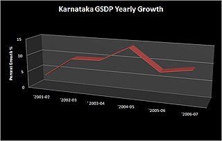
Karnataka is one of the highest economic growth states in India with an expected GSDP growth of 9.5% in the 2021–22 fiscal year. The total expected GSDP of Karnataka in 2022–2023 is about $240 billion. Karnataka recorded the highest growth rates in terms of GDP and per capita GDP in the last decade compared to other states. In 2008–09, the tertiary sector contributed the most to GSDP, followed by the secondary sector, and the primary sector.

Spiti is a high-altitude region of the Himalayas, located in the north-eastern part of the northern Indian state of Himachal Pradesh. The name "Spiti" means "The middle land", i.e. the land between Tibet and India. Spiti incorporates mainly the valley of the Spiti River, and the valleys of several rivers that feed into the Spiti River. Some of the prominent side-valleys in Spiti are the Pin valley and the Lingti valley. Spiti is bordered on the east by Tibet, on the north by Ladakh, on the west and southwest by Lahaul, on the south by Kullu, and on the southeast by Kinnaur. Spiti has a cold desert environment. The valley and its surrounding regions are among the least populated regions of India. The Bhoti-speaking local population follows Tibetan Buddhism.
Juropani (जुरोपानी) is a village development committee of the Jhapa district of Nepal.

Kalay, also known as Kale, is a town in the Sagaing Region of Myanmar. It is located upstream from Mandalay and Monywa on the Myittha River, a tributary of the Chindwin River. The town is the district headquarters of the Kalay District. It has gained importance with trans border movement enabled between Myanmar and India following the 165 kilometres (103 mi) Tamu–Kalay section of India–Myanmar–Thailand Trilateral Highway built by the Border Roads Organization of India under the Look-East Connectivity policy. Consequently, Kalay is now one of the fastest developing towns in Myanmar.
The 1999 Chamoli earthquake occurred on 29 March in the Chamoli district in the Indian state of Uttar Pradesh. Approximately 103 people died in the earthquake.
Barot, a village originally developed in 1920s for Shanan Hydel Project, is now a tourist location in Mandi district in the Indian state of Himachal Pradesh. Barot was difficult to access until 1975, when a road was opened. It is situated 40 km from Jogindernagar and 65 km from Mandi, the District Headquarter. The road to Barot branches off at Jogindernagar-Mandi Highway and from Jogindernagar the distance is 40 km. It is sometimes possible to use the funicular trolley from Jogindernagar which reduces the distance to 12 km. The road route includes terraced fields and thick cedar forests, rising to Jhatingri at the hilltop. The remains of the summer palace of the former rulers of Mandi are located here. Through the little village of Tikkan, the road carries on to Barot. The town has a range of outdoor activities, including a trout breeding centre, from where fish are released into the Uhl river. A 30 km section of the river is used for angling.

The Economy of Andhra Pradesh is primarily dependent on agriculture, which directly and indirectly employs 62% of the population. GSDP as per the first revised estimate, for the year 2022-23 is ₹13,17,728 crore. The state is ranked 1st in the country for the year 2021-22 in terms of the Gross State Domestic Product (GSDP) growth at constant prices with growth rate of 11.43%.

Puliyoor is a village in Chengannur municipality in Alappuzha district in the Indian state of Kerala.

Hill people, also referred to as mountain people, is a general term for people who live in the hills and mountains. This includes all rugged land above 300 metres (980 ft) and all land above 2,500 metres (8,200 ft) elevation. The climate is generally harsh, with steep temperature drops between day and night, high winds, runoff from melting snow and rain that cause high levels of erosion and thin, immature soils. Climate change is likely to place considerable stress on the mountain environment and the people who live there.
Shiraguppi is a village in the southern state of Karnataka, India. It is located in the Athni taluk of Belgaum district in Karnataka.
Manchi is a village in the southern state of Karnataka, India. The village has most of the lands under agriculture. Over 90% of people are literate. nearest town is B.C Road which is 12 km from Manchi. In Manchi there is a primary school established in 1950 and a high school. Roads connect B.C Road, Vitla, Mangalore and Kalladka. It is located in the Bantwal taluk of Dakshina Kannada district in Karnataka. The office of the gram panchayath is in Kukkaje.
Dul Hasti is a 390 MW hydroelectric power plant in Kishtwar district of Jammu and Kashmir, India built by NHPC. The power plant is a run-of-the-river type on the Chenab River, in a rugged, mountainous section of the Himalayas, and several hundred kilometers from larger cities in the Jammu Division. It consists of a 70 m (230 ft) tall gravity dam which diverts water through a 9.5 km (5.9 mi) long headrace tunnel to the power station which discharges back into the Chenab. The project provides peaking power to the Northern Grid with beneficiary states being Jammu and Kashmir, Punjab, Haryana, Uttar Pradesh, Uttarakhand, Rajasthan, Delhi and Union Territory of Chandigarh. It was constructed between 1985 and 2007.
Kibber, also Kibber Khas and Khyipur, is a village high in the Spiti Valley in the Himalayas at 4,270 m (14,010 ft) in Himachal Pradesh in northern India. It contains a monastery and is a base for visiting the Kibber Wildlife Sanctuary. It is located 19 km (12 mi) from Kaza and a bus service connects them in the summer months. Agriculture forms the backbone of the local economy and lush green fields are abundant. It is the base for visitors to the Kibber Wildlife Sanctuary, home to about 30 snow leopards. Treks to nearby peaks and to a high pass in the Zanskar range between Spiti and Ladakh start from Kibber.

Kurseong is a community development block that forms an administrative division in the Kurseong subdivision of the Darjeeling district in the Indian state of West Bengal.

Irrigation in India includes a network of major and minor canals from Indian rivers, groundwater well based systems, tanks, and other rainwater harvesting projects for agricultural activities. Of these groundwater system is the largest. In 2013–14, only about 36.7% of total agricultural land in India was reliably irrigated, and remaining 2/3 cultivated land in India is dependent on monsoons. 65% of the irrigation in India is from groundwater. Currently about 51% of the agricultural area cultivating food grains is covered by irrigation. The rest of the area is dependent on rainfall which is most of the times unreliable and unpredictable.
Kalyanpur is a small village and, It is a located in the Sonpur tehsil (Block) of Saran district of the state of Bihar, India. It is an altitude of 43 meters (141 ft). Kalyanpur village is situated at an 8 km (4 mi) away from the Sub-district headquarters of Sonpur and the 47 km (29 mi) away from the district headquarter of Chhapra. As per 2009 stats, Kalyanpur is the gram panchayat of Kalyanpur village. Nearby the Gularia Chowk is the small market in a kalyanpur village. Sonpur is the nearest town is an approximately 8 km away from the kalyanpur. Kalyanpur village connected by Sonpur Darihara Rewaghat road to Gandak baandh road.
| | This article related to a location in the Indian state of Uttarakhand is a stub. You can help Wikipedia by expanding it. |