
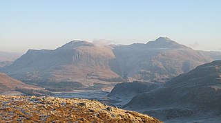
Ben Lui is a mountain in the southern Highlands of Scotland, at the head of Glen Fyne. It has five well-defined ridges radiating out from the summit. Four corries lie between the ridges; including Coire Gaothaich which lies on the northeast side of the mountain.

Ben Cruachan is a 1126 m mountain that is the highest point in Argyll and Bute, Scotland. It gives its name to the Cruachan Dam, a pumped-storage hydroelectric power station located in a cavern inside the mountain, Cruachan! is the battle cry for Highland clans Campbell and MacIntyre.

Beinn Ìme is the highest mountain in the Arrochar Alps, in the Southern Highlands of Scotland. There are three usual routes of ascent. From Succoth, one may follow the same path that is used to reach The Cobbler before taking the right fork near the base of the Cobbler's main crags and continuing up the glen, across the bealach and up Ben Ìme's eastern ridge. Alternatively, the summit can be reached from the pass of Rest and be Thankful and from the Loch Lomond side, using the private road that leads to Loch Sloy. Beinn Ìme separates the Dunbartonshire landscape of Loch Lomond in the East and the Argyll Highlands of Loch Fyne and Loch Goil anywhere north, west, south west. Beinn Ìme is the landmark to the entrance to Argyll.

Ben Avon is a mountain in the Cairngorm mountains of Scotland. The highest point of the massif, known as Leabaidh an Dàimh Bhuidhe is classified as both a Munro and a Marilyn.

Ben Chonzie, also known as Ben-y Hone, is a Scottish mountain situated eleven kilometres northwest of Crieff. It stands at 931 m (3054 ft) and is therefore listed as a Munro. It is the highest point of a large area of moorland and rounded hills between Loch Earn and Loch Tay, and with a broad, flat summit and relatively few distinguishing features, it is often regarded as one of Scotland's least interesting Munros. It is most often climbed from Invergeldie (Comrie) to the southwest; however it can also be climbed from the southeast by way of Glen Turret. The latter is longer but presents walkers with a more interesting and scenic ascent, having an array of buttresses and cliffs which can be tackled by those who feel brave, or passed by on either side. Mountain hares can be seen around the plateau area if walkers are quiet and observant. There are also many other animals on the approaches to the Ben, including Buzzards, other birds of prey, and frogs and newts in the pools alongside the landrover track that runs up the eastern aspect of the loch. Deer may be seen on the slopes to the north of the Ben.

Ben Starav is a Scottish mountain in the Highlands lying south of Glen Etive that rises to its full 1,078-metre (3,537 ft) height above Loch Etive at its western foot.
Sguman Coinntich is a mountain in the Northwest Highlands, Scotland, east of the village of Dornie in Ross-shire.

Doune Hill is a peak in the foothills of the Grampian Mountains of Scotland. It is located near the village of Luss in Argyll and Bute, west of Loch Lomond.

Beinn na Lap is a mountain in the Grampian Mountains of Scotland. It lies at the northern end of Rannoch Moor, near to Corrour railway station.
Sgurr Mor is a mountain in the Northwest Highlands of Scotland, on the southern side of Loch Quoich in Lochaber.

Ben Vuirich is a mountain in the Grampian Mountains of Scotland. It is located in Perthshire, north of the town of Pitlochry.

Ben Buie is a mountain in the south of the Isle of Mull, Scotland.

Glas Bheinn Mhor is a mountain in the Grampian Mountains of Scotland, south of Glen Etive. The Argyll and Bute and Highland border straddles its summit.

Beinn na Gucaig is a mountain in the Grampian Mountains of Scotland, located south of Fort William in Lochaber.

Beinn a' Chochuill is a mountain in the Grampian Mountains of Scotland, located east of Loch Etive in Argyll and Bute.

Meall Corranaich is a mountain in the Grampian Mountains of Scotland. It lies on the northern shore of Loch Tay in Perthshire, and is part of the Ben Lawers group.

Culardoch is a mountain in the Cairngorms of Scotland, located northeast of Braemar in Aberdeenshire.

Ben Tirran is a mountain in the Grampian Mountains of Scotland. It lies in the vast Mounth area of the eastern Highlands in Angus, on the northern side of Glen Clova.

Beinn Bheoil is a mountain in the Grampian Mountains of Scotland, located on the western shore of Loch Ericht in Highland.
Ben Gulabin is a mountain in the Mounth area of the Grampian Mountains in Scotland. It is located on the eastern side of the main A93 road between Blairgowrie and Braemar in upper Glen Shee.
