Related Research Articles
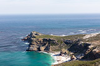
The Cape of Good Hope is a rocky headland on the Atlantic coast of the Cape Peninsula in South Africa.

A nature reserve is a protected area of importance for flora, fauna, or features of geological or other special interest, which is reserved and managed for purposes of conservation and to provide special opportunities for study or research. They may be designated by government institutions in some countries, or by private landowners, such as charities and research institutions. Nature reserves fall into different IUCN categories depending on the level of protection afforded by local laws. Normally it is more strictly protected than a nature park. Various jurisdictions may use other terminology, such as ecological protection area or private protected area in legislation and in official titles of the reserves.

The Drakensberg is the eastern portion of the Great Escarpment, which encloses the central Southern African plateau. The Great Escarpment reaches its greatest elevation – 2,000 to 3,482 metres within the border region of South Africa and Lesotho.


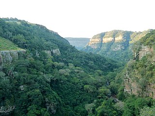
Oribi Gorge is a canyon in southern KwaZulu-Natal, South Africa, 35 kilometres north-west of Port Shepstone, which itself is 120 km south of Durban. Oribi Gorge, cut by the Mzimkulwana River, is the eastern gorge of two gorges that cut through the Oribi Flats of KwaZulu-Natal. The western gorge was formed by the Mzimkulu River. The gorge is approximately 400 metres (1,300 ft) deep, and almost 5 kilometres (3.1 mi) wide at its widest.
Ezemvelo KZN Wildlife is a governmental organisation responsible for maintaining wildlife conservation areas and biodiversity in KwaZulu-Natal Province, South Africa. Their headquarters is in Queen Elizabeth Park situated on the northern slopes of Pietermaritzburg, the KwaZulu-Natal provincial capital. Prior to 1994, it was known as the Natal Parks Board.

James Stevenson-Hamilton served from 1902–1946 as the first warden of South Africa's Sabi Nature Reserve, which was expanded under his watch and became Kruger National Park in 1926. The Tsonga people nicknamed him Skukuza because when he arrived at the area of the reserve he "turned everything upside down" with the banning of all hunting in the reserve and the relocation of all the native kraals. Skukuza camp and Skukuza Airport is named in honour of Stevenson-Hamilton, who is regarded as a champion of wildlife Conservation in South Africa.

Mtamvuna River is a river that forms the border between KwaZulu-Natal and the Eastern Cape Provinces in South Africa. The river has a wide mouth and flows into the Indian Ocean just south of Port Edward. The Mtamvuna river is approximately 162 km long with a catchment area of 1,553 km². The name means "the reaper of mouthfuls" because of the damage the river does to crops during floods.

The Highveld is the portion of the South African inland plateau which has an altitude above roughly 1500 m, but below 2100 m, thus excluding the Lesotho mountain regions to the south-east of the Highveld. It is home to some of the country's most important commercial farming areas, as well as its largest concentration of metropolitan centres, especially the Gauteng conurbation, which accommodates one-third of South Africa's population.

The Selous Game Reserve, now renamed as Nyerere National Park, is a protected area in southern Tanzania. It covers a total area of 50,000 km2 (19,000 sq mi) and has additional buffer zones. It was designated a UNESCO World Heritage Site in 1982 due to its wildlife diversity and undisturbed nature. Some of the diverse wildlife of the miombo include the African bush elephant, south-central black rhinoceros, hippopotamus, lion, African wild dog, African buffalo, Masai giraffe, Plains zebra and Nile crocodile. Permanent human habitation is not permitted within the reserve. All human entry and exit is controlled by the Wildlife Division of the Tanzanian Ministry of Natural Resources and Tourism.

The Karoo National Park is a wildlife reserve in the Great Karoo area of the Western Cape, South Africa near Beaufort West. This semi-desert area covers an area of 750 square kilometres (290 sq mi). The Nuweveld portion of the Great Escarpment runs through the Park. It is therefore partly in the Lower Karoo, at about 850 m above sea level, and partly in the Upper Karoo at over 1300 m altitude.
South African National Parks (SANParks) is the body responsible for managing South Africa's national parks. SANParks was formed in 1926, and currently manages 19 parks consisting of 3,751,113 hectares (37,511.13 km2), over 3% of the total area of South Africa.
African Parks is a non-governmental organization (NGO) focused on conservation, established in 2000 and headquartered in Johannesburg, South Africa. It was founded as the African Parks Management and Finance Company, a private company, then underwent structural changes to become an NGO called African Parks Foundation, and later renamed African Parks Network. The organization manages national parks and protected areas throughout Africa, in collaboration with governments and surrounding communities. African Parks manages 22 protected areas in 12 countries as of May 2023, and employs more than 1,100 rangers. Michael Eustace, Peter Fearnhead, Paul Fentener van Vlissingen, Anthony Hall-Martin, and Mavuso Msimang are credited as co-founders; Fearnhead continues to serve as chief executive officer. Prince Harry was appointed African Parks' president in late 2017.
The Manyeleti Game Reserve is situated in the east of the Mpumalanga province of South Africa. The game reserve is managed by the Mpumalanga Provincial Government and is over 22,750 ha in area.

The Mogalakwena River is one of the main watercourses in Limpopo Province, South Africa. It is also a major tributary of the Limpopo River.
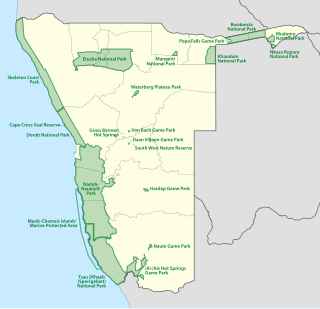
The protected areas of Namibia include its national parks and reserves. With the 2010 declaration of Dorob National Park, Namibia became the first and only country to have its entire coastline protected through a national parks network. Protected areas are subdivided into game reserves and/or nature reserves, such as special protected area, wilderness areas, natural areas, and development areas. There are also recreation reserves. Facilities in the national parks are operated by Namibia Wildlife Resorts. Over 19% of Namibia is protected, an area of some 130,000 square kilometres. However, the Ministry of Environment & Tourism auctions limited hunting rights within its protected areas. The Namibia Nature Foundation, an NGO, was established in 1987 to raise and administer funds for the conservation of wildlife and protected area management. Communal Wildlife Conservancies in Namibia help promote sustainable natural resource management by giving local communities rights to wildlife management and tourism.
The Krantzkloof Nature Reserve, managed by Ezemvelo KZN Wildlife, conserves 668 ha of the Molweni and Nkutu River gorges that incise the sandstone Kloof plateau in KwaZulu-Natal, South Africa. The reserve conserves coastal scarp forest, sourveld grassland, a cliff face biotope, and aquatic environments along its rivers. Scarp forest is a threatened forest type, protected by South Africa's forests act of 1998, while the grassland is classified as KwaZulu-Natal sandstone sourveld, the most threatened terrestrial habitat in the Durban metropole. The reserve was established in 1950 and was augmented by land donations as late as 1999.

Lekgalameetse Provincial Park is a conserved mountain wilderness of 18,718 ha, situated west of Ofcolaco and Trichardtsdal in the northern Drakensberg of Limpopo Province, South Africa. It was envisaged by the Lebowa government during the 1980s as a 25,000 ha reserve called The Downs Nature Reserve, which would cater recreational activities, camping and hiking. Current amenities include self-catering accommodation, a bush camp with log cabins beside a stream, farmhouses serving as guest houses, and a camp for school outings.
References
- ↑ Duggan, Alan; Hocking, Anthony (1990). Reader's Digest Illustrated Guide to the Game Parks and Nature Reserves of Southern Africa. Reader's Digest Association of South Africa. pp. 72–73. ISBN 978-0-947008-66-6.
- ↑ Gaffney's Local Government in South Africa. Gaffney Group. 2009. p. 981. ISBN 978-0-9814143-4-8.