
Katanga was one of the four large provinces created in the Belgian Congo in 1914. It was one of the eleven provinces of the Democratic Republic of the Congo between 1966 and 2015, when it was split into the Tanganyika, Haut-Lomami, Lualaba, and Haut-Katanga provinces. Between 1971 and 1997, its official name was Shaba Province.
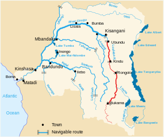
The Lualaba River flows entirely within the eastern Democratic Republic of the Congo. It provides the greatest streamflow to the Congo River, while the source of the Congo is recognized as the Chambeshi. The Lualaba is 1,800 kilometres (1,100 mi) long. Its headwaters are in the country's far southeastern corner near Musofi and Lubumbashi in Katanga Province, next to the Zambian Copperbelt.

The Luvua River is a river in the Katanga Province of the Democratic Republic of the Congo (DRC). It flows from the northern end of Lake Mweru on the Zambia-Congo border in a northwesterly direction for 350 kilometres (220 mi) to its confluence with the Lualaba River opposite the town of Ankoro. The Lualaba becomes the Congo River below the Boyoma Falls.

The Lukuga River is a tributary of the Lualaba River in the Democratic Republic of the Congo (DRC) that drains Lake Tanganyika. It is unusual in that its flow varies not just seasonally but also due to longer term climate fluctuations.
The Luama River is a tributary of the Lualaba River in the Democratic Republic of the Congo (DRC).
The Roman Catholic Prefecture Apostolic of Upper Kassai was a mission territory in the Belgian Congo. It was erected as a simple mission in 1901, and detached, as a prefecture Apostolic, from the Vicariate of Belgian Congo, on 20 August 1901.

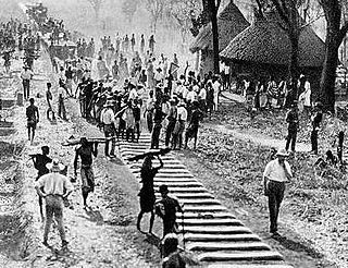
The Congo–Arab War was fought in Central Africa between the forces of Belgian King Leopold II's Congo Free State and various Zanzibari Arab slave traders led by Sefu bin Hamid, Tippu Tip's son. It was a proxy war in eastern Congo from 1892 to 1894, with most of the fighting being done by native Congolese, who aligned themselves with either side and sometimes switched sides.

Lualaba District was a district of the pre-2015 Katanga Province in the Democratic Republic of the Congo. The district dates back to the days of the Congo Free State and the Belgian Congo. The original Lualaba District was merged into Katanga in 1910, but in 1933 a new Lualaba District was formed within Katanga. After various significant boundary changes, in 2015 the district became the western part of the present Lualaba Province.

Alexandre Delcommune was a Belgian officer of the armed Force Publique of the Congo Free State who undertook extensive explorations of the country during the early colonial period of the Congo Free State. He explored many of the navigable waterways of the Congo Basin, and led a major expedition to Katanga between 1890 and 1893.
Louis-Napoléon Chaltin (1857–1933) was a Belgian career soldier and colonial official notable for his service in the Congo Free State during the late 19th century.
Lokandu is a community in Maniema Province of the Democratic Republic of the Congo, on the Lualaba River downstream from Kindu.
Paul-Amédée Le Marinel (1858–1912) was an American-born officer in the Belgian army who became an explorer and administrator in the Congo Free State. He was best known for his expedition to Katanga in 1891.

Bunkeya is a community in the Lualaba Province of the Democratic Republic of the Congo. It is located on a huge plain near the Lufira River. Before the Belgian colonial conquest, Bunkeya was the center of a major trading state under the ruler Msiri.

Haut-Lomami District was a district of the pre-2015 Katanga Province in the Democratic Republic of the Congo. The district dates back to the days of the Belgian Congo. At its greatest extent it roughly corresponded to the northern part of the current Lualaba Province and to the present Haut-Lomami Province.

The Districts of the Belgian Congo were the primary administrative divisions when Belgium annexed the Congo Free State in 1908, each administered by a district commissioner. In 1914 they were distributed among four large provinces, with some boundary changes. In 1933 the provinces were restructured into six, again with boundary changes. The number of districts fluctuated between 12 and 26 through splits and consolidations, first rising, then falling, then rising again.
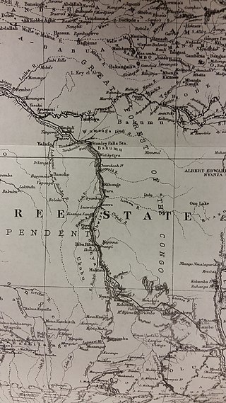
Stanley Falls District was a district of the Congo Free State. It covered most of the eastern part of the colony along the Congo River south from Stanleyville.
Lomami District was a district of the Belgian Congo from 1912 to 1933, when it was dissolved. It covered very roughly the same area as the present Lomami Province and the northwest of Haut-Lomami Province.

Tanganika District was a district of the pre-2015 Katanga Province in the Democratic Republic of the Congo. The district dates back to the days of the Belgian Congo. At its greatest extent it roughly corresponded to the present Tanganyika Province, with a small portion in the southwest now in Haut-Lomami Province.
Luapula-Moero District was a district of the pre-2015 Katanga Province in the Belgian Congo and Democratic Republic of the Congo. It roughly corresponded in area to the present Haut-Katanga Province.
The Compagnie de Chemin de fer du Katanga (CFK) was a railway company in the Congo Free State and Belgian Congo between 1902 and 1952. It held the railway concession that linked the port of Bukama on the navigable section of the Lualaba River through the mining region and the town of Elisabethville (Lubumbashi) to Sakania, where it connected with the Rhodesian railway network. Operations were subcontracted to the Compagnie du chemin de fer du bas-Congo au Katanga (BCK).
