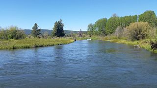
The Deschutes River in central Oregon is a major tributary of the Columbia River. The river provides much of the drainage on the eastern side of the Cascade Range in Oregon, gathering many of the tributaries that descend from the drier, eastern flank of the mountains. The Deschutes provided an important route to and from the Columbia for Native Americans for thousands of years, and then in the 19th century for pioneers on the Oregon Trail. The river flows mostly through rugged and arid country, and its valley provides a cultural heart for central Oregon. Today the river supplies water for irrigation and is popular in the summer for whitewater rafting and fishing.

Whitewater kayaking is an adventure sport where a river is navigated in a decked kayak. Whitewater kayaking includes several styles. River running; where the paddler follows a river and paddles rapids as they travel. Creeking usually involving smaller, steeper, and more technical waterways. Creek boats tend to be short but high volume to allow for manoeuvrability while maintaining buoyancy. Slalom requires paddlers to navigate through "gates". Slalom is the only whitewater event to be in the Olympics. Play boating involves staying on one feature of the river and is more artistic than the others. Squirt boating uses low-volume boats to perform special moves in whitewater features.

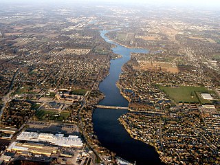
The St. Joseph River is a tributary of Lake Michigan with a length of 206 miles (332 km). The river flows in a generally westerly direction through southern Michigan and northern Indiana, United States, to its terminus on the southeast shore of the lake. It drains a primarily rural farming area in the watershed of Lake Michigan. It was enormously important to Native Americans and greatly aided in the colonial exploration, settlement and administration of New France and the nascent United States as a canoe route between Lake Michigan and the watershed of the Mississippi River.

The Niobrara National Scenic River is in north-central Nebraska, United States, approximately 300 miles (480 km) northwest of Omaha. In 1991, Congress set aside 76 miles (120 km) for preservation under the management of the National Park Service with assistance from the local Niobrara Council. Several "outstandingly remarkable values" have been designated to be protected along the Niobrara National Scenic River, including: Fish and Wildlife, Scenery, Fossil Resources, Geology, and Recreation. The river was designated by Backpacker magazine as one of the 10 best rivers for canoeing in the United States.

Vancouver Lake is located just west of Vancouver, Washington, United States, north of the Columbia River and Portland, Oregon, south of Ridgefield, Washington, and the Ridgefield National Wildlife Refuge.

Central Oregon is a geographic region in the U.S. state of Oregon and is traditionally considered to be made up of Deschutes, Jefferson, and Crook counties. Other definitions include larger areas, often encompassing areas to the north towards the Columbia River, eastward towards Burns, or south towards Klamath Falls. These three counties have a combined population of 200,431 as of the 2010 census, with Deschutes the largest of the three counties, having approximately four times the population of the other two counties combined. As of 2015, the most populous city in the region is Bend, with an estimated 87,014 residents. As defined by the three county definition, Central Oregon covers 7,833 square miles (20,290 km2) of land. Central Oregon has had 3 record tourism years beginning in 2012. Over 2.2 million people visited Central Oregon in 2012 and again in 2013.
The Missouri National Recreational River is a National Recreational River located on the border between Nebraska and South Dakota. The designation was first applied in 1978 to a 59-mile section of the Missouri River between Gavins Point Dam and Ponca State Park. In 1991, an additional 39-mile section between Fort Randall Dam and Niobrara, Nebraska, was added to the designation. These two stretches of the Missouri River are the only parts of the river between Montana and the mouth of the Missouri that remain undammed or unchannelized. The last 20 miles of the Niobrara River and 6 miles of Verdigre Creek were also added in 1991.

The River Barle runs from the Chains on northern Exmoor, in Somerset, England to join the River Exe at Exebridge, Devon. The river and the Barle Valley are both designated as biological Sites of Special Scientific Interest.

The U.S. National Whitewater Center (USNWC) is a not-for-profit outdoor recreation and athletic training facility for whitewater rafting, kayaking, canoeing, rock climbing, mountain biking hiking and ice skating which opened to the public on 2006. The Center is located in Charlotte, North Carolina on approximately 1,300 acres (530 ha) of land adjacent to the Catawba River, with more than 50 miles (80 km) of developed trail.

River surfing is the sport of surfing either standing waves, tidal bores or upstream waves in rivers. Claims for its origins include a 1955 ride of 2.4 km (1.5 mi) along the tidal bore of the River Severn.

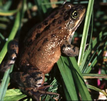
The Oregon spotted frog is a member of the frog family Ranidae of order Anura. It is a medium-sized aquatic frog endemic to the Pacific Northwest and historically well distributed in the Puget Trough/Willamette Valley province and the Cascade Mountains of south-central Washington and Oregon. It is relatively rare within its range and is listed globally as vulnerable.

The Prineville Reservoir is in the high desert hills of Central Oregon, Oregon, United States. The reservoir is on the Crooked River 14 miles (22.5 km) southeast of Prineville, and 29 miles (46.7 km) east of Bend. This reservoir is a popular retreat for most of Central Oregon. It is near the geographic center of Oregon. Prineville Reservoir State Park is managed by the Oregon Parks and Recreation Department.

The Wood River is a short river in the southern region of the U.S. state of Oregon, and part of the Klamath Basin drainage. It flows 18 miles (29 km) through the Fremont-Winema National Forests, Bureau of Land Management land, and private property in southern Oregon. Its watershed consists of 220 square miles (570 km2) of conifer forest, rural pasture land, and marsh. The river provides habitat for many species of wildlife including an adfluvial (migratory) and resident populations of native Great Basin redband trout.

Cline Falls State Scenic Viewpoint is a state park near Redmond, Oregon, United States. It is located on the Deschutes River. The park covers 9 acres (36,000 m2). It is administered by the Oregon Parks and Recreation Department.

The American River is a 30-mile (50 km)-long river in California that runs from the Sierra Nevada mountain range to its confluence with the Sacramento River in downtown Sacramento. Via the Sacramento River, it is part of the San Francisco Bay watershed. This river is fed by the melting snowpack of the Sierra Nevada and its many headwaters and tributaries, including the North Fork American River, the Middle Fork American River, and the South Fork American River.

The Boonton Gorge is a river gorge in Boonton, New Jersey where the Rockaway River drops over several waterfalls, and travels for slightly over a mile before emptying into the Jersey City Reservoir.

Canoeing – recreational boating activity or paddle sport in which you kneel or sit facing forward in an open or closed-decked canoe, and propel yourself with a single-bladed paddle, under your own power.

Todd Lake is a natural lake near the crest of the Cascade Range in central Oregon in the United States. The lake covers 45 acres (18 ha). It is named in honor of John Y. Todd, an early settler in Central Oregon. Today, the lake and surrounding forest is managed by the United States Forest Service as part of the Deschutes National Forest. The Oregon Department of Fish and Wildlife regularly stocks the lake with brook trout. There is a day-use area and a rustic campground located on the west shore of the lake. In the summer, Todd Lake is a popular outdoor recreation site for picnicking, fishing, hiking, and nature viewing. In the winter, trails in the Todd Lake area are used for cross-country skiing and snowshoeing.

Cline Falls is a 20 ft-high (6.1 m) segmented steep cascade waterfall on the Deschutes River. It is approximately 4 miles (6.4 km) west of Redmond, Oregon, United States. The waterfall is named for Cass A. Cline, who owned the land adjacent to the falls in the early 20th century. The falls occur just north of the point where Oregon Route 126 crosses the Deschutes River. The riparian area around Cline Falls provides habitat for a variety of fish and wildlife species.

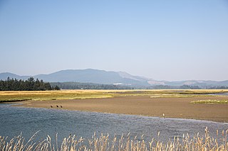
Sitka Sedge State Natural Area is an estuary and beach on the north coast of the U.S. state of Oregon in Tillamook County. Sitka Sedge consists of 357 acres (144 ha) of tidal marsh, mudflats, dunes, forested wetlands, and uplands at the south end of the Sand Lake estuary, north of Tierra Del Mar.


