
A municipality is usually a single administrative division having corporate status and powers of self-government or jurisdiction as granted by national and regional laws to which it is subordinate.

Solothurn is a town, a municipality, and the capital of the canton of Solothurn in Switzerland. It is located in the north-west of Switzerland on the banks of the Aare and on the foot of the Weissenstein Jura mountains.

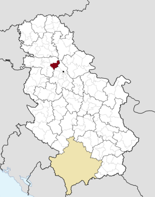
Ruma is a town and municipality in the Srem District of the Autonomous Province of Vojvodina, Serbia. As of 2011, the town has a population of 30,076, while the municipality has a population of 54,339.
Schwyz is a town and the capital of the canton of Schwyz in Switzerland.

Locarno is a southern Swiss town and municipality in the district Locarno, located on the northern shore of Lake Maggiore at its northeastern tip in the canton of Ticino at the southern foot of the Swiss Alps. It has a population of about 16,000 (proper), and about 56,000 for the agglomeration of the same name including Ascona besides other municipalities.

A hamlet is a human settlement that is smaller than a town or village. This is often simply an informal description of a smaller settlement or possibly a subdivision or satellite entity to a larger settlement. Sometimes a hamlet is defined for official or administrative purposes.

Thun is a town and a municipality in the administrative district of Thun in the canton of Bern in Switzerland. It is located where the Aare flows out of Lake Thun (Thunersee), 30 kilometres southeast of Bern.

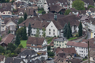
Delémont is the capital of the Swiss canton of Jura. The city has approximately 12,000 inhabitants as of 2013.

Grindelwald is a village and municipality in the Interlaken-Oberhasli administrative district in the canton of Berne. In addition to the village of Grindelwald, the municipality also includes the settlements of Alpiglen, Burglauenen, Grund, Itramen, Mühlebach, Schwendi, Tschingelberg and Wargistal.

Adelboden is a mountain village and a municipality in Switzerland, located in the Frutigen-Niedersimmental administrative district in the Bernese Highlands.

Ascona is a municipality in the district of Locarno in the canton of Ticino in Switzerland.

Porrentruy is a Swiss municipality and seat of the district of the same name located in the canton of Jura.

Vrbas is a town and municipality located in the South Bačka District of the autonomous province of Vojvodina, Serbia. As of 2022, the town has a population of 20,892, while the municipality has 36,601 inhabitants.
Stara Pazova is a village located in the Srem District of the autonomous province of Vojvodina, Serbia. The town has a population of 18,042, while Stara Pazova municipality has 65,792 inhabitants. The entrance into town from Inđija lies on 45th parallel north, it is half-way between the North pole and the equator.

Saint-Imier is a municipality in the Jura bernois administrative district in the canton of Bern in Switzerland. It is located in the French-speaking Bernese Jura.

Bodenbach is an Ortsgemeinde – a municipality belonging to a Verbandsgemeinde, a kind of collective municipality – in the Vulkaneifel district in Rhineland-Palatinate, Germany. It belongs to the Verbandsgemeinde of Kelberg, whose seat is in the like-named municipality.

Köniz is a statistical town and a municipality in the Bern-Mittelland administrative district right on the southern border to Bern in the canton of Bern in Switzerland. The municipality of Köniz as a single settlement would belong to the 15 most populous towns in Switzerland. It is also part of the larger agglomeration of Bern of about 400,000 inhabitants.
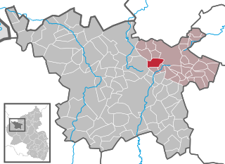
Boxberg is an Ortsgemeinde – a municipality belonging to a Verbandsgemeinde, a kind of collective municipality – in the Vulkaneifel district in Rhineland-Palatinate, Germany. It belongs to the Verbandsgemeinde of Kelberg, whose seat is in the like-named municipality.

Ankershagen is a municipality in the Mecklenburgische Seenplatte district, in Mecklenburg-Vorpommern, Germany. Components of the municipality Ankershagen are Ankershagen, Bocksee, Bornhof, Friedrichsfelde and Rumpshagen.

Máriakéménd is a village and municipality in Baranya County, Hungary.


