
Omaha is the largest city in the U.S. state of Nebraska and the county seat of Douglas County. Omaha is in the Midwestern United States on the Missouri River, about 10 mi (15 km) north of the mouth of the Platte River. The nation's 39th-largest city, Omaha's 2020 census population was 486,051.
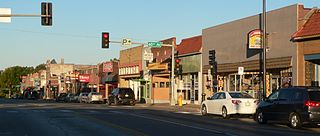
Benson is a historic neighborhood in Omaha, Nebraska. Now a pocket within North Omaha, Benson Place was originally platted in 1887 and was annexed into the City of Omaha in 1917. Actor Nick Nolte lived in the Benson area before moving to the Westside district.

North Omaha is a community area in Omaha, Nebraska, in the United States. It is bordered by Cuming and Dodge Streets on the south, Interstate 680 on the north, North 72nd Street on the west and the Missouri River and Carter Lake, Iowa on the east, as defined by the University of Nebraska at Omaha and the Omaha Chamber of Commerce.
Florence is a neighborhood in Omaha, Nebraska, United States on the city's north end and originally one of the oldest cities in Nebraska. It was incorporated by the Nebraska Territorial Legislature on March 10, 1857. The site of Winter Quarters for Mormon migrants traveling west, it has the oldest cemetery for people of European descent and oldest standing gristmill in Nebraska. Florence was the site of an illegal territorial legislature in 1858. Given the high concentration of National Register of Historic Places in the neighborhood, it is regarded as "the historic front door to Omaha as well as the state."
North Omaha, Nebraska has a recorded history spanning over 200 years, pre-dating the rest of Omaha, encompassing wildcat banks, ethnic enclaves, race riots and social change. North Omaha has roots back to 1812 and the founding of Fort Lisa. It includes the Mormon settlement of Cutler's Park and Winter Quarters in 1846, a lynching before the turn of the twentieth century, the thriving 24th Street community of the 1920s, the bustling development of its African-American community through the 1950s, a series of riots in the 1960s, and redevelopment in the late 20th and early 21st century.

The history of Omaha, Nebraska, began before the settlement of the city, with speculators from neighboring Council Bluffs, Iowa staking land across the Missouri River illegally as early as the 1840s. When it was legal to claim land in Indian Country, William D. Brown was operating the Lone Tree Ferry to bring settlers from Council Bluffs to Omaha. A treaty with the Omaha Tribe allowed the creation of the Nebraska Territory, and Omaha City was founded on July 4, 1854. With early settlement came claim jumpers and squatters, and the formation of a vigilante law group called the Omaha Claim Club, which was one of many claim clubs across the Midwest. During this period many of the city's founding fathers received lots in Scriptown, which was made possible by the actions of the Omaha Claim Club. The club's violent actions were challenged successfully in a case ultimately decided by the U.S. Supreme Court, Baker v. Morton, which led to the end of the organization.
The neighborhoods of Omaha are a diverse collection of community areas and specific enclaves. They are spread throughout the Omaha metro area, and are all on the Nebraska side of the Missouri River.

The Bemis Park Landmark Heritage District is located in North Omaha, Nebraska. Situated from Cuming Street to Hawthorne Avenue, Glenwood Avenue to 33rd Street, Bemis Park was annexed into Omaha in 1887, and developed from 1889-1922. The district was designated an Omaha Landmark in 1983.
The Near North Side of Omaha, Nebraska is the neighborhood immediately north of downtown. It forms the nucleus of the city's African-American community, and its name is often synonymous with the entire North Omaha area. It is bordered by Cuming Street on the south, 30th on the west, 16th on the east, and Locust Street to the north.
Scriptown was the name of the first subdivision in the history of Omaha, which at the time was located in Nebraska Territory. It was called "Scriptown" because scrip was used as payment, similar to how a company would pay employees when regular money was unavailable. Its original survey placed the location from the Missouri River to North 30th Street, Cuming to Fort Street.
Little Italy is a neighborhood in Omaha, Nebraska which served as the historic home to Omahans of Italian ancestry. It was the source of many laborers for the Union Pacific railroad, much of Omaha's bootlegging during Prohibition and the Santa Lucia Procession, which started in 1924 and continues annually.

Little Bohemia, or Bohemian Town, is a historic neighborhood in Omaha, Nebraska. Starting in the 1880s, Czech immigrants settled in this highly concentrated area, also called "Praha" (Prague) or "Bohemian Town", bounded by South 10th Street on the east, South 16th Street on the west, Pierce Street on the north, and Martha Street on the south, with a commercial area went along South 13th and South 14th Streets, centered on William Street. It was located south of downtown, and directly west of Little Italy. A portion of the neighborhood along South 13th Street was listed on the National Register of Historic Places in 2020.
Gifford Park is a historic neighborhood in midtown Omaha, Nebraska. It is roughly bounded by the North Freeway on the east, North 38th Street on the west, Dodge Street on the south and Cuming Street on the north. Its namesake park was added to the City parks network in 1916. The neighborhood is bounded by several historic neighborhoods, including Bemis Park, Gold Coast, and the Near North Side.
Walnut Hill is a historic neighborhood located in north Omaha, Nebraska. It is bounded by North 40th Street on the east, Cuming Street on the south, Northwest Radial Highway and Saddle Creek Road on the west and Hamilton Street on the north.

Transportation in Omaha, Nebraska, includes most major modes, such as pedestrian, bicycle, automobile, bus, train and airplane. While early transportation consisted of ferries, stagecoaches, steamboats, street railroads, and railroads, the city's transportation systems have evolved to include the Interstate Highway System, parklike boulevards and a variety of bicycle and pedestrian trails. The historic head of several important emigrant trails and the First Transcontinental Railroad, its center as a national transportation hub earned Omaha the nickname "Gate City of the West" as early as the 1860s.

The present Douglas County Courthouse is located at 1701 Farnam Street in Omaha, Nebraska, United States. Built in 1912, it was added to the National Register of Historic Places in 1979. Notable events at the courthouse include two lynchings and the city's first sit-in during the Civil Rights Movement. Five years after it was opened, the building was almost destroyed by mob violence in the Omaha Race Riot of 1919.
The Omaha and Council Bluffs Railway and Bridge Company, known as O&CB, was incorporated in 1886 in order to connect Omaha, Nebraska with Council Bluffs, Iowa over the Missouri River. With a sanctioned monopoly over streetcar service in the two cities, the O&CB was among the earliest major electric street railway systems in the nation, and was one of the last streetcar operators in the U.S., making its last run in 1955.
The Jewish Community Center in Omaha, Nebraska was established in 1926, and moved to its present location at 333 South 132nd Street in 1973. The original JCC was the site of important labor organizing in the city, and has continued to serve as an important center for financial support in Omaha's Jewish community throughout its history. Today the JCC is the site of a Holocaust memorial that is unique in the Midwestern United States. In 2008 teams from the United States Olympic Trials practiced at the JCC before partaking in the official trials in downtown Omaha.

The Elmwood Park neighborhood in Omaha, Nebraska is a historically significant area that was developed in the late 19th and early 20th century. It extends from Leavenworth Street on the north to Center Street on the south; from South 50th Street on the east to South 72nd Street on the west. Home to ethnic Swede celebrations through the 1950s, today the neighborhood's park hosts the city's "Shakespeare on the Green" festival.
The Omaha Public Library in Omaha Nebraska currently has 12 locations.

