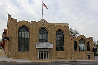
The Sokol Auditorium is located at 2234 South 13th Street in the Little Bohemia neighborhood of South Omaha, Nebraska. It is a local icon for its historical context, as well as modern musical performances and gymnastics. It has a maximum capacity of 1,500.
Saratoga Springs, Nebraska Territory, or Saratoga, was a boom and bust town founded in 1856 that throve for several years. During its short period of influence the town grew quickly, outpacing other local settlements in the area including Omaha and Florence, and briefly considered as a candidate for the Nebraska Territorial capitol. Saratoga was annexed into Omaha in 1887, and has been regarded a neighborhood in North Omaha since then.

Fort Omaha, originally known as Sherman Barracks and then Omaha Barracks, is an Indian War-era United States Army supply installation. Located at 5730 North 30th Street, with the entrance at North 30th and Fort Streets in modern-day North Omaha, Nebraska, the facility is primarily occupied by Metropolitan Community College. A Navy Operational Support Center and Marine Corps Reserve unit, along with an Army Reserve unit occupy the periphery of the 82.5 acres (33.4 ha) fort. The government deeded all but four parcels of the land to the community college in 1974.

The Bemis Park Landmark Heritage District is located in North Omaha, Nebraska. Situated from Cuming Street to Hawthorne Avenue, Glenwood Avenue to 33rd Street, Bemis Park was annexed into Omaha in 1887, and developed from 1889-1922. The district was designated an Omaha Landmark in 1983.
The Near North Side of Omaha, Nebraska is the neighborhood immediately north of downtown. It forms the nucleus of the city's African-American community, and its name is often synonymous with the entire North Omaha area. It is bordered by Cuming Street on the south, 30th on the west, 16th on the east, and Locust Street to the north.
The Kountze Place neighborhood of Omaha, Nebraska is a historically significant community on the city's north end. Today the neighborhood is home to several buildings and homes listed on the National Register of Historic Places. It is located between North 16th Avenue on the east to North 30th Street on the west; Locust Street on the south to Pratt Street on the north. Kountze Place was annexed into Omaha in 1887. The neighborhood was built as a suburban middle and upper middle class enclave for doctors, lawyers, successful businessmen and other professional workers.
The Miller Park neighborhood in North Omaha, Nebraska is a historically significant community housing a historic district and several notable historic places. It is located between Sorenson Parkway on the south and Redick Avenue on the north, Florence Boulevard on the east and 30th Street on the west. The Minne Lusa neighborhood borders on the north, and the Saratoga neighborhood is on the south. Fort Omaha borders the neighborhood on the west. Miller Park is the namesake park in the neighborhood, as well as the Miller Park Elementary School. In 2017, the Miller Park/Minne Lusa area was ranked as having the 2nd highest rate of homicides and other violent crimes out of 81 Omaha neighborhoods.
Little Italy is a neighborhood in Omaha, Nebraska which served as the historic home to Omahans of Italian ancestry. It was the source of many laborers for the Union Pacific railroad, much of Omaha's bootlegging during Prohibition and the Santa Lucia Procession, which started in 1924 and continues annually.

Little Bohemia, or Bohemian Town, is a historic neighborhood in Omaha, Nebraska. Starting in the 1880s, Czech immigrants settled in this highly concentrated area, also called "Praha" (Prague) or "Bohemian Town", bounded by South 10th Street on the east, South 16th Street on the west, Pierce Street on the north, and Martha Street on the south, with a commercial area went along South 13th and South 14th Streets, centered on William Street. It was located south of downtown, and directly west of Little Italy. A portion of the neighborhood along South 13th Street was listed on the National Register of Historic Places in 2020.
Walnut Hill is a historic neighborhood located in north Omaha, Nebraska. It is bounded by North 40th Street on the east, Cuming Street on the south, Northwest Radial Highway and Saddle Creek Road on the west and Hamilton Street on the north.

The Vinton Street Commercial Historic District is located along Vinton Street between Elm Street on the west and South 17th Street on the east in south Omaha, Nebraska. This district is located adjacent to Sheelytown, a residential neighborhood that had historically significant populations of Irish, Poles, and Eastern European immigrants. It grew along with the success of the Union Stockyards and South Omaha. It was added to the National Register of Historic Places in 2006.

The Old Post Office was located at 16th and Dodge Streets in Omaha, Nebraska. Built in 1898, the building was demolished in 1966. During the process of being demolished the building, along with the Old City Hall, became a rallying force for historic preservation in Omaha.

The present Douglas County Courthouse is located at 1701 Farnam Street in Omaha, Nebraska, United States. Built in 1912, it was added to the National Register of Historic Places in 1979. Notable events at the courthouse include two lynchings and the city's first sit-in during the Civil Rights Movement. Five years after it was opened, the building was almost destroyed by mob violence in the Omaha Race Riot of 1919.
The Redick Mansion, also known as the Mayne Mansion and Redick Hall, was located at 3612 North 24th Street in North Omaha, Nebraska. It served as the first home of Omaha University, now known as the University of Nebraska at Omaha, from 1909 through 1917. A five-story tower on the front of the mansion was a notable landmark throughout the area.
The Orchard Hill is a neighborhood in North Omaha, Nebraska. One of the oldest neighborhoods in the city, Orchard Hill is home to some of the city's oldest homes. The neighborhood's boundaries are Hamilton Street on the south, Blondo Street on the north, 36th Street on the east and the Omaha Belt Line on the west. The John A. Creighton Boulevard runs through the eastern part of the neighborhood.

Old Gold Coast is the name of a historic district in south Omaha, Nebraska. With South 10th Street as the central artery, the area was home to neighborhoods such as Little Italy and Forest Hill. The area is referred to as "old" because it was replaced in prominence in the late 19th century when a new district usurped its importance. This area south of downtown was generally bounded by Leavenworth Street on the north, Bancroft Street on the south, the Missouri River on the east, and South 16th Street on the west.
The Swift Packing Plant was a division of Swift and Company located at South 27th and Q Streets in South Omaha, Nebraska. The plant was opened in 1887 and closed in 1969. It covered approximately eight square blocks and consisted of several brick and stone buildings, and was located in proximity to the Omaha Stockyards. It was located on the South Omaha Terminal Railway, and next to the Omaha Stockyards, making Swift one of the "Big Four" packing companies in Omaha.
The Wilson Packing Plant was a division of the Wilson and Company meatpacking company located near South 27th and Y Streets in South Omaha, Nebraska. Founded in the 1890s, it closed in 1976. It occupied the area bounded by Washington Street, South 27th Street, W Street and South 30th Street. Located on the South Omaha Terminal Railway and next to the Omaha Stockyards, Wilson was regarded as one of the "Big Four" packing companies in Omaha.
13th Street is a two-way street that runs south-north in Omaha, Nebraska. Historically significant areas along the street include Squatter's Row, Little Italy, Little Bohemia, and Mount Vernon Gardens.
Fair Deal Cafe was a historically significant diner for the African American community in North Omaha, Nebraska. Once known as the "Black City Hall", Fair Deal was located at North 24th & Burdette in the Near North Omaha neighborhood from 1954 - 2003.

