Eppley Airfield, also known as Omaha Airport, is an airport in the midwestern United States, located three miles (5 km) northeast of downtown Omaha, Nebraska. On the west bank of the Missouri River in Douglas County, it is the largest airport in Nebraska, with more arrivals and departures than all other airports in the state combined. It is classified as a medium hub airport by the Federal Aviation Administration (FAA). It is owned and operated by the Omaha Airport Authority (OAA).
The climate of Salt Lake City, Utah features cold and snowy winters, hot and dry summers, and modest to light seasonal rainfall. Lying in the Salt Lake Valley, the city is surrounded by mountains and the Great Salt Lake. Under the Köppen climate classification, Salt Lake City has either a Mediterranean climate (Csa) or dry-summer continental climate (Dsa) depending on which variant of the system is used, though it borders on a cold semi-arid climate (BSk) due to the city's relatively low precipitation.

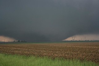
The tornado outbreak sequence of March 1913 was a devastating series of tornado outbreaks that affected the northern Great Plains, the Southern United States, and sections of the upper Midwest over a two-day-long period between March 21–23, 1913. Composed of two outbreaks, the sequence first began with a tornado outbreak that commenced in Mississippi early on March 21. Several significant tornadoes occurred, one of which killed seven people in one family and another destroyed much of Lower Peach Tree, Alabama, with 27 deaths all in that town. The tornado at Lower Peach Tree is estimated to have been equivalent to a violent F4 tornado on the Fujita scale, based upon damage accounts. The tornadoes occurred between 0630 and 1030 UTC, or pre-dawn local time, perhaps accounting for the high number of fatalities—a common trend in tornadoes in the Dixie Alley. In all, tornadoes in Mississippi, Georgia, and Alabama killed 48 people, perhaps more, that day and injured at least 150 people.

The climate of Minneapolis–Saint Paul is the long term weather trends and historical events of the Minneapolis–Saint Paul metropolitan area in east central Minnesota. Minneapolis and St. Paul, together known as the Twin Cities, are the core of the 15th largest metropolitan area in the United States. With a population of 3.6 million people, the region contains approximately 60% of the population of Minnesota. Due to its location in the northern and central portion of the U.S., the Twin Cities has the coldest average temperature of any major metropolitan area in the nation. Winters are very cold, summer is warm and humid, snowfall is common in the winter and thunderstorms with heavy rainfall occur during the spring, summer and autumn. Though winter can be cold, the area receives more sunlight hours in mid-winter than many other warmer parts of the country, including all of the Great Lakes states, the Pacific Northwest, parts of the South, and almost all of the Northeast. Unless otherwise indicated, all normals data presented below are based on data at Minneapolis/St. Paul International Airport, the official Twin Cities climatology station, from the 1981−2010 normals period.

St. Louis is located at 38°38′53″N90°12′44″W.

Minnesota has a humid continental climate, with hot summers and cold winters. Minnesota's location in the Upper Midwest allows it to experience some of the widest variety of weather in the United States, with each of the four seasons having its own distinct characteristics. The area near Lake Superior in the Minnesota Arrowhead region experiences weather unique from the rest of the state. The moderating effect of Lake Superior keeps the surrounding area relatively cooler in the summer and warmer in the winter, giving that region a smaller yearly temperature variation. On the Köppen climate classification, much of the southern third of Minnesota—roughly from the Twin Cities region southward—falls in the hot summer zone (Dfa), and the northern two-thirds of Minnesota falls in the warm summer zone (Dfb).
The climate of Houston is classified as a humid subtropical climate, with tropical influences. August normally ranks as the warmest month at an average temperature of 84.6 °F (29.2 °C) and January the coldest month at an average temperature of 53.1 °F (11.7 °C).
East Omaha is a geographically designated community located in Omaha, Nebraska. Located three miles (5 km) from downtown Omaha, East Omaha is the site of Eppley Omaha International Airport, Omaha's main airport, and Carter Lake. This area was Omaha's first annexation, joining the city in 1854. Originally separated from Omaha by the Missouri River, a large section of the area's land was dissected by a ruling from the U.S. Supreme Court in 1892. Today, 2,500 houses, a school, grocery stores and a church that made up the original town have been demolished and replaced by several government facilities, the Eppley Airfield, and more.
Dallas is located in North Texas, built along the Trinity River. It has a humid subtropical climate that is characteristic of the southern plains of the United States. Dallas experiences mild winters and hot summers.

North Dakota's climate is typical of a continental climate with cold winters and warm-hot summers. The state's location in the Upper Midwest allows it to experience some of the widest variety of weather in the United States, and each of the four seasons has its own distinct characteristics. The eastern half of the state has a humid continental climate with warm to hot, somewhat humid summers and cold, windy winters, while the western half has a semi-arid climate with less precipitation and less humidity but similar temperature profiles. The areas east of the Missouri River get slightly colder winters, while those west of the stream get higher summer daytime temperatures. In general, the diurnal temperature difference is prone to be more significant in the west due to higher elevation and less humidity.
The tornado outbreak sequence of June 3–11, 2008 was a series of tornado outbreaks affecting most of central and eastern North America from June 3–11, 2008. 192 tornadoes were confirmed, along with widespread straight–line wind wind damage. Seven people were killed from a direct result of tornadoes; four in Iowa, two in Kansas, and one in Indiana. Eleven additional people were killed across five states by other weather events including lightning, flash flooding, and straight-line winds. Severe flooding was also reported in much of Indiana, Wisconsin, Minnesota and Iowa as a result of the same thunderstorms, while high heat and humidity affected much of eastern North America; particularly along the eastern seaboard of the United States from New York City to the Carolinas.

The climate of Massachusetts is mainly a humid continental climate, with hot, humid summers and cold, snowy winters and abundant precipitation. Massachusetts is a state located in the New England region of the northeastern United States. Most of its population of 7.0 million live in the Boston metropolitan area. The eastern half of this relatively small state is mostly urban and suburban. Massachusetts is the most populous of the six New England states and ranks third in the nation by population density and fourth by GDP per capita. Massachusetts receives about 43 inches or 1,090 millimetres of rain annually, fairly evenly distributed throughout the year, slightly wetter during the winter. Summers are warm with average high temperatures in July above 80 °F or 26.7 °C and overnight lows above 60 °F or 15.6 °C common throughout the state. Winters are cold, but generally less extreme on the coast with high temperatures in the winter averaging above freezing even in January, although areas further inland are much colder. The state does have extreme temperatures from time to time with 100 °F or 37.8 °C in the summer and temperatures below 0 °F or −17.8 °C in the winter not being unusual.

From May 3 to May 11, 2003, a prolonged and destructive series of tornado outbreaks affected much of the Great Plains and Eastern United States. Most of the severe activity was concentrated between May 4 and May 10, which saw more tornadoes than any other week-long span in recorded history; 335 tornadoes occurred during this period, concentrated in the Ozarks and central Mississippi River Valley. Additional tornadoes were produced by the same storm systems from May 3 to May 11, producing 363 tornadoes overall, of which 62 were significant. Six of the tornadoes were rated F4, and of these four occurred on May 4, the most prolific day of the tornado outbreak sequence; these were the outbreak's strongest tornadoes. Damage caused by the severe weather and associated flooding amounted to US$4.1 billion, making it the costliest U.S. tornado outbreak of the 2000s. A total of 50 deaths and 713 injuries were caused by the severe weather, with a majority caused by tornadoes; the deadliest tornado was an F4 that struck Madison and Henderson counties in Tennessee, killing 11.
Abbott Drive is a roadway mostly in Omaha, Nebraska, United States, but passes briefly through Carter Lake, Iowa. It is the easternmost link in Omaha's Park and Boulevard System that connects the eastern edge of Creighton University and North Downtown Omaha or NoDo to Carter Lake, Iowa, Eppley Airfield to John J Pershing Drive on the eastern end of Florence, Nebraska. Considered "Omaha's gateway", the drive includes a distinctive "string of pearls" lighting feature.

A significant and destructive tornado outbreak that affected parts of the Midwestern United States and lower Great Plains in mid-May 2013. This event occurred just days after a deadly outbreak struck Texas and surrounding southern states on May 15. On May 16, a slow moving trough crossed the Rockies and traversed the western Great Plains. Initially, activity was limited to scattered severe storms; however, by May 18, the threat for organized severe thunderstorms and tornadoes greatly increased. A few tornadoes touched down that day in Kansas and Nebraska, including an EF4 tornado near Rozel, Kansas. Maintaining its slow eastward movement, the system produced another round of severe weather nearby. Activity significantly increased on May 19, with tornadoes confirmed in Oklahoma, Kansas, Iowa, Missouri, and Illinois. In Oklahoma, two strong tornadoes, one rated EF4, caused significant damage in rural areas of the eastern Oklahoma City metropolitan area; two people lost their lives near Shawnee. The most dramatic events unfolded on May 20 as a large EF5 tornado devastated parts of Moore, Oklahoma, killing 24 people. Thousands of structures were destroyed, with many being completely flattened. Several other tornadoes occurred during the day in areas further eastward, though the majority were weak and caused little damage.

The Great Flood of 1913 occurred between March 23 and March 26, after major rivers in the central and eastern United States flooded from runoff and several days of heavy rain. Related deaths and damage in the United States were widespread and extensive. While the exact number is not certain, flood-related deaths in Ohio, Indiana, and eleven other states are estimated at approximately 650. The official death toll range for Ohio falls between 422 and 470. Flood-related death estimates in Indiana range from 100 to 200. More than a quarter million people were left homeless. The death toll from the flood of 1913 places it second to the Johnstown Flood of 1889 as one of the deadliest floods in the United States. The flood remains Ohio's largest weather disaster. In the Midwestern United States, damage estimates exceeded a third of a billion dollars. Damage from the Great Dayton Flood at Dayton, Ohio, exceeded $73 million. Indiana's damages were estimated at $25 million. Further south, along the Mississippi River, damages exceeded $200 million. Devastation from the flood of 1913 and later floods along the Mississippi River eventually changed the country's management of its waterways and increased federal support for comprehensive flood prevention and funding for flood control projects. The Ohio Conservancy Act, which was signed by the governor of Ohio in 1914, became a model for other states to follow. The act allowed for the establishment of conservancy districts with the authority to implement flood control projects.
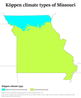
Climate change in Missouri encompasses the effects of climate change, attributed to man-made increases in atmospheric carbon dioxide, in the U.S. state of Missouri.

The following is a list of weather events that occurred on Earth in the year 2020.

The climate of Door County, Wisconsin is tempered by Green Bay and Lake Michigan. There are fewer extremely cold days and fewer hot days than in areas of Wisconsin directly to the west. Lake waters delay the coming of spring as well as extend mild temperatures in the fall. Annual precipitation is slightly lower than elsewhere in northern Wisconsin. The county features a humid continental climate with warm summers and cold snowy winters.
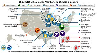
The following is a list of weather events that occurred on Earth in the year 2022. The year began with a La Niña. There were several natural disasters around the world from various types of weather, including blizzards, cold waves, droughts, heat waves, wildfires, floods, tornadoes, and tropical cyclones. The deadliest weather event of the year were the European heat waves, which killed over 26,000 people, 11,000 of which were in France. The costliest weather event of the year was Hurricane Ian, which caused at least $112.9 billion in damages in Florida and Cuba. Another significant weather event was the Pakistan floods, which killed 1,739 people and a total of $14.9 billion in damages.