Related Research Articles

Omaha is the most populous city in the U.S. state of Nebraska and the county seat of Douglas County. It is located in the Midwestern United States along the Missouri River, about 10 mi (15 km) north of the mouth of the Platte River. The nation's 40th-most populous city, Omaha had a population of 486,051 as of the 2020 census. It is the anchor of the eight-county Omaha–Council Bluffs metropolitan area, which extends into Iowa and is the 58th-largest metro area in the United States, with a population of 967,604. Furthermore, the greater Omaha–Council Bluffs–Fremont combined statistical area had 1,004,771 residents in 2020. Omaha is ranked as a global city by the Globalization and World Cities Research Network, which in 2020 gave it "sufficiency" status.

The Mount Vernon Trail (MVT) is an 18-mile (29 km) long shared use path that travels along the George Washington Memorial Parkway in Northern Virginia between Rosslyn and George Washington's home at Mount Vernon. The trail connects the easternmost portions of Arlington County, the City of Alexandria, and Fairfax County, and travels mostly on dedicated trail with a small portion on city streets. As part of U.S. Bike Route 1, the Potomac Heritage Trail and the East Coast Greenway, the MVT opened in April 1972 as a gravel path and was subsequently expanded and paved.

Three Rivers Park District is a special park district serving the suburban areas of the Twin Cities including suburban Hennepin, Carver, Dakota, Scott, and Ramsey counties. Three Rivers's mission is "To promote environmental stewardship through recreation and education in a natural resources-based park system." Three Rivers operates twenty parks and ten regional trails, with at least two more regional trails planned. Nearly seven million people visit Three Rivers facilities each year. It has over 27,000 acres (11,000 ha) of parks and trails.

North Omaha is a community area in Omaha, Nebraska, in the United States. It is bordered by Cuming and Dodge Streets on the south, Interstate 680 on the north, North 72nd Street on the west and the Missouri River and Carter Lake, Iowa on the east, as defined by the University of Nebraska at Omaha and the Omaha Chamber of Commerce.

Sligo Creek Trail is a paved hiker-biker trail running along Sligo Creek in the suburbs of Washington, D.C. Most of the trail passes through tree-filled parkland. The trail and surrounding park is a popular place for locals to jog, walk, bicycle, roller-skate, and take their children to the playground. Many local families enjoy picnicking at one of the 15 picnic areas along the trail.
The neighborhoods of Omaha are a diverse collection of community areas and specific enclaves. They are spread throughout the Omaha metro area, and are all on the Nebraska side of the Missouri River.
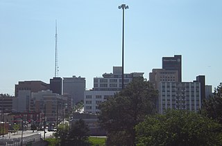
Midtown is a geographic area of Omaha, Nebraska that is a culturally, socially and economically important area of the city. It is home to major research centers, national corporations, several historic districts, and a number of historic residences.
Morton Meadows is a historic neighborhood located in Midtown Omaha, Nebraska. The neighborhood lies between Center and Leavenworth Streets, from 42nd Street to Saddle Creek, and is sometimes referred to by its central boulevard, Twin Ridge. It is near the Dundee area, as well as the Gold Coast, Field Club and Country Club historic districts.
The Miller Park neighborhood in North Omaha, Nebraska is a historically significant community housing a historic district and several notable historic places. It is located between Sorenson Parkway on the south and Redick Avenue on the north, Florence Boulevard on the east and 30th Street on the west. The Minne Lusa neighborhood borders on the north, and the Saratoga neighborhood is on the south. Fort Omaha borders the neighborhood on the west. Miller Park is the namesake park in the neighborhood, as well as the Miller Park Elementary School. In 2017, the Miller Park/Minne Lusa area was ranked as having the 2nd highest rate of homicides and other violent crimes out of 81 Omaha neighborhoods.
Florence Boulevard, originally known as the Prettiest Mile in Omaha Boulevard, is a boulevard-type north-south street in the north Omaha, Nebraska. With the start of construction in 1892, Florence Boulevard was the first roadway in Omaha's boulevard system designed by Horace Cleveland. Florence Boulevard was the first roadway in Omaha to be fully lit with electric lamps.

Boulevards in Omaha are part of a park and boulevard system originally designed in 1889 by Horace Cleveland. There are more than one hundred miles (160 km) of boulevards throughout the city of Omaha, Nebraska today.

Trails in Omaha, Nebraska include 80 miles (130 km) of paved trails as well as unpaved trails and paths for recreational usage throughout the city. Popular among bicyclists, runners, hikers and recreational walkers, these trails are included in comprehensive plans for the City of Omaha, the Omaha metro area, Douglas County, and long-distance coordinated plans between the municipalities of southeast Nebraska.

The Lincoln Highway in Omaha, Nebraska, runs east–west from near North 183rd Street and West Dodge Road in Omaha, Nebraska, towards North 192nd Street outside of Elkhorn. This section of the Lincoln Highway, one of only 20 miles (32 km) that were paved with brick in Nebraska, is one of the most well-preserved in the country. The roadway was listed on the National Register of Historic Places in 1984. The Lincoln Highway was the first road across the United States, traversing coast-to-coast from Times Square in New York City to Lincoln Park in San Francisco, California.

Transportation in Omaha, Nebraska, includes most major modes, such as pedestrian, bicycle, automobile, bus, train and airplane. While early transportation consisted of ferries, stagecoaches, steamboats, street railroads, and railroads, the city's transportation systems have evolved to include the Interstate Highway System, parklike boulevards and a variety of bicycle and pedestrian trails. The historic head of several important emigrant trails and the First transcontinental railroad, its center as a national transportation hub earned Omaha the nickname "Gate City of the West" as early as the 1860s.

The Saddle Creek Underpass is located in the Midtown area of Omaha, Nebraska. Designed to carry Saddle Creek Road under Dodge Street, the underpass was constructed in 1934 by the Works Progress Administration. It was included on the Bridges in Nebraska Multiple Property Submission on June 29, 1992.
Dodge Street is the main east–west street in Omaha, Nebraska. Numbered as U.S. Route 6 (US 6), the street starts in Downtown Omaha and connects to West Dodge Road just west of 78th Street. From there, it continues westward through the remainder of Douglas County.

The Elmwood Park neighborhood in Omaha, Nebraska is a historically significant area that was developed in the late 19th and early 20th century. It extends from Leavenworth Street on the north to Center Street on the south; from South 50th Street on the east to South 72nd Street on the west. Home to ethnic Swede celebrations through the 1950s, today the neighborhood's park hosts the city's "Shakespeare on the Green" festival.

The parkway system of Louisville, Kentucky, also known as the Olmsted Park System, was designed by the firm of preeminent 19th century landscape architect Frederick Law Olmsted. The 26-mile (42 km) system was built from the early 1890s through the 1930s, and initially owned by a state-level parks commission, which passed control to the city of Louisville in 1942.

The Indianapolis Park and Boulevard System is a group of parks, parkways, and boulevards in Indianapolis, Indiana, that was designed by landscape architect George Edward Kessler in the early part of the twentieth century. Also known as the Kessler System, the district includes 3,474 acres (1,406 ha) and has shaped the city through the present day. This historic district was added to the National Register of Historic Places in 2003.

Skyline Parkway is a scenic byway in Duluth, Minnesota. The road stretches 28 miles (45 km) from Becks Road to Seven Bridges Road, and is split into West Skyline Parkway and East Skyline Parkway. It follows the ancient shoreline of Glacial Lake Duluth. The byway is known for its views of Duluth, Superior, Wisconsin, the Saint Louis River and Lake Superior.
References
- ↑ Colman, Z. (August 15, 2010) "City becomes more bike friendly" Archived 2012-09-08 at archive.today , Omaha World Herald . Retrieved March 19, 2011.
- ↑ Newton, M.B. (1891) Anecdotes of Omaha , Festner Printing Co. Retrieved March 19, 2011.
- ↑ Larsen, L.H. and Cottrell, B.J. (1997) The Gate City: A history of Omaha. University of Nebraska Press. p 106".
- ↑ "Omaha's Suburban Park Plan". City of Omaha. p 63. Retrieved 9/15/07.
- ↑ "Highway Bridges in Nebraska 1870 - 1942" (pdf). National Register of Historic Places Inventory - Multiple Property Documentation Form. National Park Service. May 6, 1984. Retrieved 18 May 2012.
- ↑ "Photos: Omaha streets and how they got their names". Omaha World Herald. May 1, 2019. Retrieved 25 Jun 2021.