
South Omaha is a former city and current district of Omaha, Nebraska, United States. During its initial development phase the town's nickname was "The Magic City" because of the seemingly overnight growth, due to the rapid development of the Union Stockyards. Annexed by the City of Omaha in 1915, the community has numerous historical landmarks many are within the South Omaha Main Street Historic District.

The Admiral Theatre is located at 2234 South 13th Street in the Little Bohemia neighborhood of South Omaha, Nebraska. It is a local icon for its historical context, as well as modern musical performances for rock and country music. It has a maximum capacity of 1,500. It was originally known as the Sokol Auditorium from 1926 to 2021.
Benson is a historic neighborhood in Omaha, Nebraska. Now a pocket within North Omaha, Benson Place was originally platted in 1887 and was annexed into the City of Omaha in 1917. Actor Nick Nolte lived in the Benson area before moving to the Westside district.

North Omaha is a community area in Omaha, Nebraska, in the United States. It is bordered by Cuming and Dodge Streets on the south, Interstate 680 on the north, North 72nd Street on the west and the Missouri River and Carter Lake, Iowa on the east, as defined by the University of Nebraska at Omaha and the Omaha Chamber of Commerce.
Cabanne's Trading Post was established in 1822 by the American Fur Company as Fort Robidoux near present-day Dodge Park in North Omaha, Nebraska, United States. It was named for the influential fur trapper Joseph Robidoux. Soon after it was opened, the post was called the French Company or Cabanné's Post, for the ancestry and name of its operator, Jean Pierre Cabanné, who was born and raised among the French community of St. Louis, Missouri.
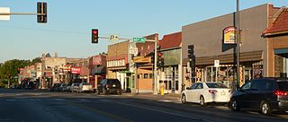
The South Omaha Main Street Historic District is located along South 24th Street between M and O Streets in South Omaha, Nebraska. It was added to the National Register of Historic Places in 1989. Home to dozens of historically important buildings, including the Packer's National Bank Building, the historic district included 129 acres (0.52 km2) and more than 32 buildings when listed.
The Country Club Historic District is located in Omaha, Nebraska from 50th to 56th Streets and from Corby to Seward Streets. It includes dozens of homes built between 1925 and 1949 in the late 19th and 20th Century Revival styles. It was added to the National Register of Historic Places in 2004.

The Gold Coast Historic District is located in Midtown Omaha, Nebraska. Listed on the National Register of Historic Places in 1997, this historic district covers approximately a 30 block area roughly bounded by 36th, 40th, Jones, and Cuming Streets. The neighborhood housed many of Omaha's cultural and financial leaders between 1900 and 1920, taking over from Omaha's original Gold Coast in prominence.

The Omaha Rail and Commerce Historic District, roughly bounded by Jackson, 15th, and 8th Streets, as well as the Union Pacific main line, is located in downtown Omaha, Nebraska. Today this historic district includes several buildings listed individually on the National Register of Historic Places, including the Union Pacific Depot and the Burlington Station.

The Bemis Park Landmark Heritage District is located in North Omaha, Nebraska. Situated from Cuming Street to Hawthorne Avenue, Glenwood Avenue to 33rd Street, Bemis Park was annexed into Omaha in 1887, and developed from 1889 to 1922. The district was designated an Omaha Landmark in 1983.
The Miller Park neighborhood in North Omaha, Nebraska, is a historically significant community housing a historic district and several notable historic places. It is located between Sorenson Parkway on the south and Redick Avenue on the north, Florence Boulevard on the east and 30th Street on the west. The Minne Lusa neighborhood borders on the north, and the Saratoga neighborhood is on the south. Fort Omaha borders the neighborhood on the west. Miller Park is the namesake park in the neighborhood, as well as the Miller Park Elementary School. In 2017, the Miller Park/Minne Lusa area was ranked as having the 2nd highest rate of homicides and other violent crimes out of 81 Omaha neighborhoods.
Little Italy is a neighborhood in Omaha, Nebraska which served as the historic home to Omahans of Italian ancestry. It was the source of many laborers for the Union Pacific railroad, much of Omaha's bootlegging during Prohibition and the Santa Lucia Procession, which started in 1924 and continues annually.

Little Bohemia, or Bohemian Town, is a historic neighborhood in Omaha, Nebraska. Starting in the 1880s, Czech immigrants settled in this highly concentrated area, also called "Praha" (Prague) or "Bohemian Town", bounded by South 10th Street on the east, South 16th Street on the west, Pierce Street on the north, and Martha Street on the south, with a commercial area went along South 13th and South 14th Streets, centered on William Street. It was located south of downtown, and directly west of Little Italy. A portion of the neighborhood along South 13th Street was listed on the National Register of Historic Places in 2020.
Forest Lawn Memorial Park, also known as Forest Lawn Cemetery, is located at 7909 Mormon Bridge Road in North Omaha, Nebraska. It was established in 1885 when the mutual Forest Lawn Cemetery Association was donated 100 acres (0.40 km2) in northwest of the city. In 1886, the first interment in the cemetery was the donor of the land, John H. Brackin. Forest Lawn is Omaha's largest cemetery and the burial location of many of Omaha's second generation of leadership.
Sheelytown was a historic ethnic neighborhood in South Omaha, Nebraska, USA with populations of Irish, Polish and other first generation immigrants. Located north of the Union Stockyards, it was bounded by Edward Creighton Boulevard on the north, Vinton Street on the south, South 24th Street to the east, and 35th Street to the west. Sheelytown was named for the Sheely Brothers Packing Houses that were located in the area. Sheelytown was annexed by Omaha in 1887. The Omaha Quartermaster Depot was built just east of the community across the Union Pacific tracks.

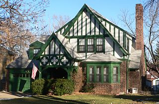
Vinton School was built as a fourteen-room elementary school in 1908 at 2120 Deer Park Boulevard in the Deer Park neighborhood of Omaha, Nebraska, United States. Designed by Omaha architect Frederick W. Clarke, Vinton School is the earliest and most elaborate example of a Tudor Revival-style school in Omaha. Designated an Omaha Landmark in June 1990, the building was listed on the National Register of Historic Places in November 1989.

The Douglas County Courthouse is located at 1701 Farnam Street in Omaha, Nebraska, United States. Built in 1912, it was added to the National Register of Historic Places in 1979. Notable events at the courthouse include two lynchings and the city's first sit-in during the Civil Rights Movement. Five years after it was opened, the building was almost destroyed by mob violence in the Omaha Race Riot of 1919.

The Elsasser Bakery is a building at 1802 and 1804 Vinton Street in South Omaha, Nebraska, USA. The building was constructed in 1923 for the William L. Elsasser Bakery. The Elsasser name is carved into a stone panel at the top of the red brick building. The building was added to the National Register of Historic Places in 2006 as part of the admission of the Vinton Street Commercial Historic District. The building's main occupant is currently the River City Saloon.

The Arthur G. Rocheford Building is a historic commercial building at 1717 Vinton Street in South Omaha, Nebraska, United States. The building was built in 1913 to house Arthur G. Rocheford's Globe Plumbing Company. Rocheford served as the general contractor during construction of the building. The building was added to the National Register of Historic Places in 2006 as part of the admission of the Vinton Street Commercial Historic District.


