
South Omaha is a former city and current district of Omaha, Nebraska, United States. During its initial development phase the town's nickname was "The Magic City" because of the seemingly overnight growth, due to the rapid development of the Union Stockyards. Annexed by the City of Omaha in 1915, the community has numerous historical landmarks many are within the South Omaha Main Street Historic District.

North Omaha is a community area in Omaha, Nebraska, in the United States. It is bordered by Cuming and Dodge Streets on the south, Interstate 680 on the north, North 72nd Street on the west and the Missouri River and Carter Lake, Iowa on the east, as defined by the University of Nebraska at Omaha and the Omaha Chamber of Commerce.
Florence is a present-day neighborhood in Omaha, Nebraska, United States on the city's north end and was one of the oldest cities in Nebraska before being annexed by Omaha. Given the high concentration of National Register of Historic Places in the neighborhood, it is acknowledged that "The historic Florence neighborhood was a city before Nebraska was officially a state," and is regarded as "the historic front door to Omaha as well as the state."

The Great Plains Black History Museum currently resides on the first floor of the historic Jewell Building in North Omaha, Nebraska. It was formerly located at 2213 Lake Street in the Near North Side neighborhood in North Omaha. It was housed in the Webster Telephone Exchange Building, which is listed on the National Register of Historic Places. A nationally renowned institution for more than 40 years, the museum includes more than 100,000 periodicals, manuscripts, photographs and research materials. The museum currently conducts programs and presents exhibits throughout Omaha, the State of Nebraska, regionally and nationally upon request.

Field Club is an affluent and historic neighborhood located in the Midtown region of Omaha, Nebraska. Roughly bounded by Pacific Street, 32nd Avenue, Center St., and 36th Street, the neighborhood was placed on the National Register of Historic Places as a historic district on November 15, 2000. Field Club is the location of dozens of historically significant homes in the Omaha area, including the Gerald R. Ford Birthsite and Gardens.

The Gold Coast Historic District is located in Midtown Omaha, Nebraska. Listed on the National Register of Historic Places in 1997, this historic district covers approximately a 30 block area roughly bounded by 36th, 40th, Jones, and Cuming Streets. The neighborhood housed many of Omaha's cultural and financial leaders between 1900 and 1920, taking over from Omaha's original Gold Coast in prominence.
Morton Meadows is a historic neighborhood located in Midtown Omaha, Nebraska. The neighborhood lies between Center and Leavenworth Streets, from 42nd Street to Saddle Creek, and is sometimes referred to by its central boulevard, Twin Ridge. It is near the Dundee area, as well as the Gold Coast, Field Club and Country Club historic districts.

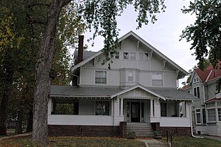
The Bemis Park Landmark Heritage District is located in North Omaha, Nebraska. Situated from Cuming Street to Hawthorne Avenue, Glenwood Avenue to 33rd Street, Bemis Park was annexed into Omaha in 1887, and developed from 1889 to 1922. The district was designated an Omaha Landmark in 1983.
The Near North Side of Omaha, Nebraska is the neighborhood immediately north of downtown. It forms the nucleus of the city's historic African-American community, and its name is often synonymous with the entire North Omaha area. Originally established immediately after Omaha was founded in 1854, the Near North Side was once confined to the area around Dodge Street and North 7th Street. Eventually, it gravitated west and north, and today it is bordered by Cuming Street on the south, 30th on the west, 16th on the east, and Locust Street to the north. Countless momentous events in Omaha's African American community happened in the Near North Side, including the 1865 establishment of the first Black church in Omaha, St. John's AME; the 1892 election of the first African American state legislator, Dr. Matthew Ricketts; the 1897 hiring of the first Black teacher in Omaha, Ms. Lucy Gamble, the 1910 Jack Johnson riots, the Omaha race riot of 1919 that almost demolished the neighborhood and many other events.
The Kountze Place neighborhood of Omaha, Nebraska is a historically significant community on the city's north end. Today the neighborhood is home to several buildings and homes listed on the National Register of Historic Places. It is located between North 16th Avenue on the east to North 30th Street on the west; Locust Street on the south to Pratt Street on the north. Kountze Place was annexed into Omaha in 1887. The neighborhood was built as a suburban middle and upper middle class enclave for doctors, lawyers, successful businessmen and other professional workers.
The Miller Park neighborhood in North Omaha, Nebraska, is a historically significant community housing a historic district and several notable historic places. It is located between Sorenson Parkway on the south and Redick Avenue on the north, Florence Boulevard on the east and 30th Street on the west. The Minne Lusa neighborhood borders on the north, and the Saratoga neighborhood is on the south. Fort Omaha borders the neighborhood on the west. Miller Park is the namesake park in the neighborhood, as well as the Miller Park Elementary School. In 2017, the Miller Park/Minne Lusa area was ranked as having the 2nd highest rate of homicides and other violent crimes out of 81 Omaha neighborhoods.

Little Bohemia, or Bohemian Town, is a historic neighborhood in Omaha, Nebraska. Starting in the 1880s, Czech immigrants settled in this highly concentrated area, also called "Praha" (Prague) or "Bohemian Town", bounded by South 10th Street on the east, South 16th Street on the west, Pierce Street on the north, and Martha Street on the south, with a commercial area went along South 13th and South 14th Streets, centered on William Street. It was located south of downtown, and directly west of Little Italy. A portion of the neighborhood along South 13th Street was listed on the National Register of Historic Places in 2020.

Jobbers Canyon Historic District was a large industrial and warehouse area comprising 24 buildings located in downtown Omaha, Nebraska, US. It was roughly bound by Farnam Street on the north, South Eighth Street on the east, Jackson Street on the south, and South Tenth Street on the west. In 1989, all 24 buildings in Jobbers Canyon were demolished, representing the largest National Register historic district loss to date.

The Vinton Street Commercial Historic District is located along Vinton Street between Elm Street on the west and South 17th Street on the east in south Omaha, Nebraska. This district is located adjacent to Sheelytown, a residential neighborhood that had historically significant populations of Irish, Poles, and Eastern European immigrants. It grew along with the success of the Union Stockyards and South Omaha. It was added to the National Register of Historic Places in 2006.
Sheelytown was a historic ethnic neighborhood in South Omaha, Nebraska, USA with populations of Irish, Polish and other first generation immigrants. Located north of the Union Stockyards, it was bounded by Edward Creighton Boulevard on the north, Vinton Street on the south, South 24th Street to the east, and 35th Street to the west. Sheelytown was named for the Sheely Brothers Packing Houses that were located in the area. Sheelytown was annexed by Omaha in 1887. The Omaha Quartermaster Depot was built just east of the community across the Union Pacific tracks.

Downtown Omaha is the central business, government and social core of the Omaha–Council Bluffs metropolitan area, U.S. state of Nebraska. The boundaries are Omaha's 20th Street on the west to the Missouri River on the east and the centerline of Leavenworth Street on the south to the centerline of Chicago Street on the north, also including the CHI Health Center Omaha. Downtown sits on the Missouri River, with commanding views from the tallest skyscrapers.

Vinton School was built as a fourteen-room elementary school in 1908 at 2120 Deer Park Boulevard in the Deer Park neighborhood of Omaha, Nebraska, United States. Designed by Omaha architect Frederick W. Clarke, Vinton School is the earliest and most elaborate example of a Tudor Revival-style school in Omaha. Designated an Omaha Landmark in June 1990, the building was listed on the National Register of Historic Places in November 1989.

The Douglas County Courthouse is located at 1701 Farnam Street in Omaha, Nebraska, United States. Built in 1912, it was added to the National Register of Historic Places in 1979. Notable events at the courthouse include two lynchings and the city's first sit-in during the Civil Rights Movement. Five years after it was opened, the building was almost destroyed by mob violence in the Omaha Race Riot of 1919.
The West Farnam neighborhood or the Blackstone neighborhood in Omaha, Nebraska is located from Dodge Street on the north to Leavenworth Street on the south, Highway 75/Interstate 480 on the east to South 52nd Street on the west. In 1997, the Gold Coast Historic District was formed from the West Farnam neighborhood and the Park Place neighborhood, known today as Cathedral. Named for its principal thoroughfare, West Farnam was a prime real estate area in the first quarter of the 20th century. It is home to several historical landmarks, including houses, churches, and former hotels.
The Carver Savings and Loan Association opened in 1944 as the first African-American financial institution in Omaha, Nebraska. Located at 2416 Lake Street next to the historic North 24th Street corridor, it was in the heart of the Near North Omaha neighborhood, and Omaha's African-American business district.


