Council Bluffs is a city in and the county seat of Pottawattamie County, Iowa, United States. The city is the most populous in Southwest Iowa, and forms part of the Omaha (Nebr.) Metropolitan Area. It is located on the east bank of the Missouri River, across from the city of Omaha. Council Bluffs was known, until at least 1853, as Kanesville. It was the historic starting point of the Mormon Trail. Kanesville is also the northernmost anchor town of the other emigrant trails, since there was a steam powered boat to ferry their wagons, and cattle, across the Missouri River.

Winter Quarters was an encampment formed by approximately 2,500 members of The Church of Jesus Christ of Latter-day Saints as they waited during the winter of 1846–47 for better conditions for their trek westward. It followed a preliminary tent settlement some 3½ miles west at Cutler's Park. The Mormons built more than 800 cabins at the Winter Quarters settlement. Located in present-day North Omaha overlooking the Missouri River, the settlement remained populated until 1848.

The Dundee–Happy Hollow Historic District is located west of Midtown Omaha, Nebraska. It covers the area between Leavenworth Street on the south, Hamilton Street on the north, Happy Hollow Boulevard on the west, and 46th Street on the east. The "heart" of Dundee is located at 50th and Underwood Avenue in Omaha, Nebraska, United States. It was founded in 1880 and annexed into the city in 1915. Dundee is home to Warren Buffett and nationally syndicated editorial cartoonist Jeff Koterba and birthplace of Academy Award-winning filmmaker Alexander Payne.
Saratoga Springs, Nebraska Territory, or Saratoga, was a boom and bust town founded in 1856 that throve for several years. During its short period of influence the town grew quickly, outpacing other local settlements in the area including Omaha and Florence, and briefly considered as a candidate for the Nebraska Territorial capitol. Saratoga was annexed into Omaha in 1887, and has been regarded a neighborhood in North Omaha since then.
The neighborhoods of Omaha are a diverse collection of community areas and specific enclaves. They are spread throughout the Omaha metro area, and are all on the Nebraska side of the Missouri River.
The Near North Side of Omaha, Nebraska is the neighborhood immediately north of downtown. It forms the nucleus of the city's African-American community, and its name is often synonymous with the entire North Omaha area. It is bordered by Cuming Street on the south, 30th on the west, 16th on the east, and Locust Street to the north.
The Kountze Place neighborhood of Omaha, Nebraska is a historically significant community on the city's north end. Today the neighborhood is home to several buildings and homes listed on the National Register of Historic Places. It is located between North 16th Avenue on the east to North 30th Street on the west; Locust Street on the south to Pratt Street on the north. Kountze Place was annexed into Omaha in 1887. The neighborhood was built as a suburban middle and upper middle class enclave for doctors, lawyers, successful businessmen and other professional workers.
The Miller Park neighborhood in North Omaha, Nebraska is a historically significant community housing a historic district and several notable historic places. It is located between Sorenson Parkway on the south and Redick Avenue on the north, Florence Boulevard on the east and 30th Street on the west. The Minne Lusa neighborhood borders on the north, and the Saratoga neighborhood is on the south. Fort Omaha borders the neighborhood on the west. Miller Park is the namesake park in the neighborhood, as well as the Miller Park Elementary School. In 2017, the Miller Park/Minne Lusa area was ranked as having the 2nd highest rate of homicides and other violent crimes out of 81 Omaha neighborhoods.
Scriptown was the name of the first subdivision in the history of Omaha, which at the time was located in Nebraska Territory. It was called "Scriptown" because scrip was used as payment, similar to how a company would pay employees when regular money was unavailable. Its original survey placed the location from the Missouri River to North 30th Street, Cuming to Fort Street.
Little Italy is a neighborhood in Omaha, Nebraska. Historically the home to the city's Italian population, Little Italy was the source for much of Omaha's bootlegging during Prohibition, many laborers for the Union Pacific railroad, and the Santa Lucia Procession, which started in 1924 and continues annually.
Gifford Park is a historic neighborhood in midtown Omaha, Nebraska. It is roughly bounded by the North Freeway on the east, North 38th Street on the west, Dodge Street on the south and Cuming Street on the north. Its namesake park was added to the City parks network in 1916. The neighborhood is bounded by several historic neighborhoods, including Bemis Park, Gold Coast, and the Near North Side.
The Union Stockyards of Omaha, Nebraska were founded in 1883 in South Omaha by the Union Stock Yards Company of Omaha. A fierce rival of Chicago's Union Stock Yards, the Omaha Union Stockyards were third in the United States for production by 1890. In 1947 they were second to Chicago in the world. Omaha overtook Chicago as the nation's largest livestock market and meat packing industry center in 1955, a title which it held onto until 1971. The 116-year-old institution closed in 1999. The Livestock Exchange Building was listed on the National Register of Historic Places in 1999.

Hanscom Park is a historic neighborhood in Midtown Omaha, Nebraska. Its namesake public park is one of the oldest parks in Omaha, donated to the City in 1872. U.S. President Gerald R. Ford was born in a house in the Hanscom Park neighborhood. Its boundaries are Center Street on the north, South 42nd on the west, Interstate 480 on the east and I-80 on the south.
Walnut Hill is a historic neighborhood located in north Omaha, Nebraska. It is bounded by North 40th Street on the east, Cuming Street on the south, Northwest Radial Highway and Saddle Creek Road on the west and Hamilton Street on the north.
The Florence School is located at 7902 North 36th Street in the Florence neighborhood of north Omaha, Nebraska, United States. The first school in the Florence area was built in the 1840s, in what was then called Cutler's Park by Mormon pioneers. The present-day Florence Elementary School was started in the late 1850s after the town of Florence was founded.
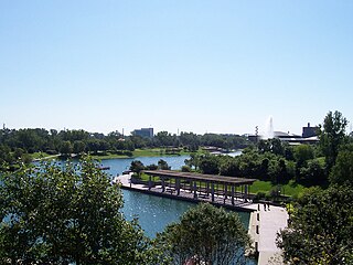
Heartland of America Park is a public park located at 800 Douglas Street in downtown Omaha, Nebraska, USA. The 31-acre (130,000 m2) park is situated between Interstate 80 and the Missouri River, and is adjacent to Gene Leahy Mall and the Old Market and connects to Lewis & Clark Landing. Where the park sits has been the site of exploration, expansion and now, recreation. Lewis and Clark reportedly discovered conspicuous earthen mounds when they explored the location in 1804. Historians speculate the mounds may have been natural or the remains of an Otoe village. Opened in 1990, the park was built on recovered after the controversial demolition of the Jobbers Canyon Historic District. The area, filled with warehouses dating to the 1870s, was integral to the growth and development of Omaha.
Gibson Bend of the Missouri River is a meander located in Pottawattamie County, Iowa and Douglas County, Nebraska, located at 41°11′15″N95°55′15″W. The Gibson neighborhood is a community area in Omaha, Nebraska abutting the Gibson Bend.
The Wilson Packing Plant was a division of the Wilson and Company meatpacking company located near South 27th and Y Streets in South Omaha, Nebraska. Founded in the 1890s, it closed in 1976. It occupied the area bounded by Washington Street, South 27th Street, W Street and South 30th Street. Located on the South Omaha Terminal Railway and next to the Omaha Stockyards, Wilson was regarded as one of the "Big Four" packing companies in Omaha.
13th Street is a two-way street that runs south-north in Omaha, Nebraska. Historically significant areas along the street include Squatter's Row, Little Italy, Little Bohemia, and Mount Vernon Gardens.
The Carver Savings and Loan Association opened in 1944 as the first African-American financial institution in Omaha, Nebraska. Located at 2416 Lake Street next to the historic North 24th Street corridor, it was in the heart of the Near North Omaha neighborhood, Omaha's African-American business district.