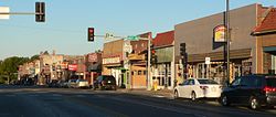
Florence is a neighborhood in Omaha, Nebraska, United States on the city's north end and originally one of the oldest cities in Nebraska. It was incorporated by the Nebraska Territorial Legislature on March 10, 1857. The site of Winter Quarters for Mormon migrants traveling west, it has the oldest cemetery for people of European descent and oldest standing gristmill in Nebraska. Florence was the site of an illegal territorial legislature in 1858. Given the high concentration of National Register of Historic Places in the neighborhood, it is regarded as "the historic front door to Omaha as well as the state."
Significant events in the history of North Omaha, Nebraska include the Pawnee, Otoe and Sioux nations; the African American community; Irish, Czech, and other European immigrants, and; several other populations. Several important settlements and towns were built in the area, as well as important social events that shaped the future of Omaha and the history of the nation. The timeline of North Omaha history extends to present, including recent controversy over schools.
Saratoga Springs, Nebraska Territory, or Saratoga, was a boom and bust town founded in 1856 that throve for several years. During its short period of influence the town grew quickly, outpacing other local settlements in the area including Omaha and Florence, and briefly considered as a candidate for the Nebraska Territorial capitol. Saratoga was annexed into Omaha in 1887, and has been regarded a neighborhood in North Omaha since then.

The history of Omaha, Nebraska began before the settlement of the city, with speculators from neighboring Council Bluffs, Iowa staking land across the Missouri River illegally as early as the 1840s. When it was legal to claim land in Indian Country, William D. Brown was operating the Lone Tree Ferry to bring settlers from Council Bluffs to Omaha. A treaty with the Omaha Tribe allowed the creation of the Nebraska Territory, and Omaha City was founded on July 4, 1854. With early settlement came claim jumpers and squatters, and the formation of a vigilante law group called the Omaha Claim Club, which was one of many claim clubs across the Midwest. During this period many of the city's founding fathers received lots in Scriptown, which was made possible by the actions of the Omaha Claim Club. The club's violent actions led to the U.S. Supreme Court trial, Baker v. Morton, which led to the end of the organization.
The neighborhoods of Omaha are a diverse collection of community areas and specific enclaves. They are spread throughout the Omaha metro area, and are all on the Nebraska side of the Missouri River.

The Bemis Park Landmark Heritage District is located in North Omaha, Nebraska. Situated from Cuming Street to Hawthorne Avenue, Glenwood Avenue to 33rd Street, Bemis Park was annexed into Omaha in 1887, and developed from 1889-1922. The district was designated an Omaha Landmark in 1983.
The Near North Side of Omaha, Nebraska is the neighborhood immediately north of downtown. It forms the nucleus of the city's African-American community, and its name is often synonymous with the entire North Omaha area. It is bordered by Cuming Street on the south, 30th on the west, 16th on the east, and Locust Street to the north.
The Kountze Place neighborhood of Omaha, Nebraska is a historically significant community on the city's north end. Today the neighborhood is home to several buildings and homes listed on the National Register of Historic Places. It is located between North 16th Avenue on the east to North 30th Street on the west; Locust Street on the south to Pratt Street on the north. Kountze Place was annexed into Omaha in 1887. The neighborhood was built as a suburban middle and upper middle class enclave for doctors, lawyers, successful businessmen and other professional workers.
Gifford Park is a historic neighborhood in midtown Omaha, Nebraska. It is roughly bounded by the North Freeway on the east, North 38th Street on the west, Dodge Street on the south and Cuming Street on the north. Its namesake park was added to the City parks network in 1916. The neighborhood is bounded by several historic neighborhoods, including Bemis Park, Gold Coast, and the Near North Side.
The South Omaha Land Company was created in South Omaha, Nebraska in 1887. Founders included William A. Paxton.

The economy of Omaha, Nebraska has served as a major commercial hub in the Midwestern United States since its founding in 1854. Dubbed the "Motor Mouth City" by The New York Times, Omaha is widely regarded as the telecommunications capital of the United States. The city's economy includes agriculture, food processing, insurance, transportation, healthcare and education. Warren Buffett of Berkshire Hathaway has lived in Omaha all of his life, as have the ConAgra Foods, Union Pacific Railroad and Mutual of Omaha Companies, and Kiewit Corporation, all Fortune 500 corporations.
Sheelytown was a historic ethnic neighborhood in South Omaha, Nebraska, USA with populations of Irish, Polish and other first generation immigrants. Located north of the Union Stockyards, it was bounded by Edward Creighton Boulevard on the north, Vinton Street on the south, South 24th Street to the east, and 35th Street to the west. Sheelytown was named for the Sheely Brothers Packing Houses that were located in the area. Sheelytown was annexed by Omaha in 1887. The Omaha Quartermaster Depot was built just east of the community across the Union Pacific tracks.
Erastus A. Benson (1854–1932) was a banker, investor and land speculator in Omaha, Nebraska. Born and raised in Iowa, after graduating from the University of Iowa Benson speculated in land around Omaha. After investing in early business ventures in the phonograph and the Kinetoscope, Benson staged an unsuccessful bid to become the mayor of Omaha. In addition to being one of the inaugural members of the influential National Phonograph Association, the former town of Benson, Nebraska was named after him.
Lincoln Boulevard in Omaha, Nebraska was built in the early 1890s as part of the city's boulevard system under control of the Board of Park Commissioners. It runs through the Bemis Park neighborhood west-east from Mercer Boulevard to its end at North 29 Street; it then reemerges immediately north of Dodge Street, where it intersects with Turner Boulevard.
Fontenelle Park is a 108-acre (0.44 km2) public park located at 4575 Ames Avenue, at an intersection of Fontenelle Boulevard in North Omaha, Nebraska. In the late 1940s, the park made headlines across the Midwestern United States as the possible home of a minor league baseball team.
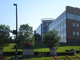
First National Business Park is located at 144th & Dodge Streets, just north of Boys Town in West Omaha. CB Richard Ellis regards the park as Omaha's "most prestigious location". It was a significant part of the largest annexation in Omaha's history, which former mayor Hal Daub called for in 1999.
Benson Park is located at 7028 Military Avenue in the Benson neighborhood of Omaha, Nebraska. The 217-acre (88 ha) park includes a lake and pavilion, as well as a scenic picnic area.

The Elmwood Park neighborhood in Omaha, Nebraska is a historically significant area that was developed in the late 19th and early 20th century. It extends from Leavenworth Street on the north to Center Street on the south; from South 50th Street on the east to South 72nd Street on the west. Home to ethnic Swede celebrations through the 1950s, today the neighborhood's park hosts the city's "Shakespeare on the Green" festival.

The Benson City Hall and Fire Station, now known as the Benson Community Center, is located at 6008 Maple Street in the Benson neighborhood of Omaha, Nebraska. It was built in 1915, shortly before Benson's annexation by Omaha.
The Prospect Hill neighborhood in North Omaha, Nebraska is one of the oldest neighborhoods in the city. In addition to being home to some of the city's oldest structures, the neighborhood is also the site of the Prospect Hill Cemetery, Omaha's pioneer cemetery. The neighborhood's boundaries are North 30th Street from Hamilton Street to Lake and up to Creighton Boulevard; then over to Blondo and up to North 38th Street to Hamilton. The Omaha Belt Line ran near the northwest corner of the neighborhood. The neighborhood is also home to the historic Franklin Elementary School.