
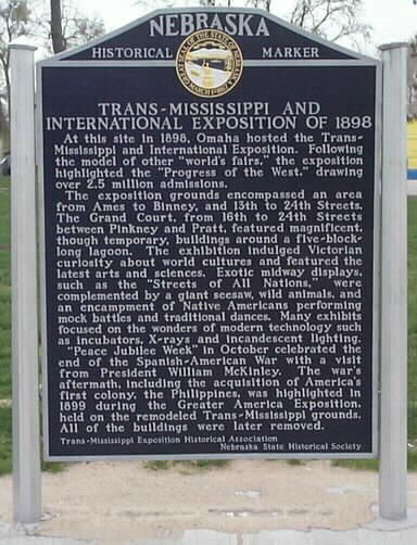
The Trans-Mississippi and International Exposition was a world's fair held in Omaha, Nebraska, from June 1 to November 1 of 1898. Its goal was to showcase the development of the entire West from the Mississippi River to the Pacific Coast. The Indian Congress was held concurrently. Over 2.6 million people came to Omaha to view the 4,062 exhibits during the five months of the Exposition. President William McKinley and William Jennings Bryan were among the dignitaries who attended at the invitation of Gurdon Wattles, the event's leader. A hundred thousand people assembled on the plaza to hear them speak. The Expo stretched over a 180-acre (0.73 km2) tract in North Omaha and featured a 2,000-foot-long (610 m) lagoon encircled by 21 classical buildings that featured fine and modern products from around the world.

North Omaha is a community area in Omaha, Nebraska, in the United States. It is bordered by Cuming and Dodge Streets on the south, Interstate 680 on the north, North 72nd Street on the west and the Missouri River and Carter Lake, Iowa on the east, as defined by the University of Nebraska at Omaha and the Omaha Chamber of Commerce.
East Omaha is a geographically designated community located in Omaha, Nebraska. Located three miles (5 km) from downtown Omaha, East Omaha is the site of Eppley Omaha International Airport, Omaha's main airport, and Carter Lake. This area was Omaha's first annexation, joining the city in 1854. Originally separated from Omaha by the Missouri River, a large section of the area's land was dissected by a ruling from the U.S. Supreme Court in 1892. Today, 2,500 houses, a school, grocery stores and a church that made up the original town have been demolished and replaced by several government facilities, the Eppley Airfield, and more.
North Omaha, Nebraska has a recorded history spanning over 200 years, pre-dating the rest of Omaha, encompassing wildcat banks, ethnic enclaves, race riots and social change. North Omaha has roots back to 1812 and the founding of Fort Lisa. It includes the Mormon settlement of Cutler's Park and Winter Quarters in 1846, a lynching before the turn of the twentieth century, the thriving 24th Street community of the 1920s, the bustling development of its African-American community through the 1950s, a series of riots in the 1960s, and redevelopment in the late 20th and early 21st century.
Significant events in the history of North Omaha, Nebraska include the Pawnee, Otoe and Sioux nations; the African American community; Irish, Czech, and other European immigrants, and; several other populations. Several important settlements and towns were built in the area, as well as important social events that shaped the future of Omaha and the history of the nation. The timeline of North Omaha history extends to present, including recent controversy over schools.
Saratoga Springs, Nebraska Territory, or Saratoga, was a boom and bust town founded in 1856 that thrived for several years. During its short period of influence the town grew quickly, outpacing other local settlements in the area including Omaha and Florence, and briefly considered as a candidate for the Nebraska Territorial capitol. Saratoga was annexed into Omaha in 1887, and has been regarded a neighborhood in North Omaha since then.
The history of Omaha, Nebraska, began before the settlement of the city, with speculators from neighboring Council Bluffs, Iowa staking land across the Missouri River illegally as early as the 1840s. When it was legal to claim land in Indian Country, William D. Brown was operating the Lone Tree Ferry to bring settlers from Council Bluffs to Omaha. A treaty with the Omaha Tribe allowed the creation of the Nebraska Territory, and Omaha City was founded on July 4, 1854. With early settlement came claim jumpers and squatters, and the formation of a vigilante law group called the Omaha Claim Club, which was one of many claim clubs across the Midwest. During this period many of the city's founding fathers received lots in Scriptown, which was made possible by the actions of the Omaha Claim Club. The club's violent actions were challenged successfully in a case ultimately decided by the U.S. Supreme Court, Baker v. Morton, which led to the end of the organization.
The neighborhoods of Omaha are a diverse collection of community areas and specific enclaves. They are spread throughout the Omaha metro area, and are all on the Nebraska side of the Missouri River.
The George H. Kelly House is located at 1924 Binney Street in the Near North Side neighborhood of Omaha, Nebraska, United States. Built in 1904 in the Neo-Classical Revival style, it was listed on the National Register of Historic Places in 1983, and designated a City of Omaha architectural landmark that same year.

Calvin Memorial Presbyterian Church, located at 3105 North 24th Street, was formed in 1954 as an integrated congregation in North Omaha, Nebraska. Originally called the North Presbyterian Church, the City of Omaha has reported, "Calvin Memorial Presbyterian Church is architecturally significant to Omaha as a fine example of the Neo-Classical Revival Style of architecture." It was designated a City of Omaha landmark in 1985; it was listed on the National Register of Historic Places as North Presbyterian Church in 1986.
The Kountze Place neighborhood of Omaha, Nebraska is a historically significant community on the city's north end. Today the neighborhood is home to several buildings and homes listed on the National Register of Historic Places. It is located between North 16th Avenue on the east to North 30th Street on the west; Locust Street on the south to Pratt Street on the north. Kountze Place was annexed into Omaha in 1887. The neighborhood was built as a suburban middle and upper middle class enclave for doctors, lawyers, successful businessmen and other professional workers.

The Sherman is a historically significant apartment building located at 2501 North 16th Street in the Near North Side of Omaha, Nebraska. Built in 1897, it was designated an Omaha landmark in 1985; in 1986 it was listed on the National Register of Historic Places.
The Miller Park neighborhood in North Omaha, Nebraska, is a historically significant community housing a historic district and several notable historic places. It is located between Sorenson Parkway on the south and Redick Avenue on the north, Florence Boulevard on the east and 30th Street on the west. The Minne Lusa neighborhood borders on the north, and the Saratoga neighborhood is on the south. Fort Omaha borders the neighborhood on the west. Miller Park is the namesake park in the neighborhood, as well as the Miller Park Elementary School. In 2017, the Miller Park/Minne Lusa area was ranked as having the 2nd highest rate of homicides and other violent crimes out of 81 Omaha neighborhoods.
Scriptown was the name of the first subdivision in the history of Omaha, which at the time was located in Nebraska Territory. It was called "Scriptown" because scrip was used as payment, similar to how a company would pay employees when regular money was unavailable. Its original survey placed the location from the Missouri River to North 30th Street, Cuming to Fort Street.
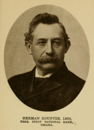
Herman Kountze was a powerful and influential pioneer banker in Omaha, Nebraska, during the late 19th century. After organizing the Kountze Brothers Bank in 1857 as the second bank in Omaha, Herman and his brothers Augustus, Charles and Luther changed the charter in 1863, opening the First National Bank of Omaha that year. Kountze was involved in a number of influential ventures around Omaha, including the development of the Omaha Stockyards and the Trans-Mississippi and International Exposition of 1898. Immediately after his death Kountze was regarded as one of Omaha's "old settlers". Today Kountze's First National Bank is the oldest bank west of the Mississippi River, and continues as a privately held company in its sixth generation of family ownership.
Florence Boulevard, originally known as the Prettiest Mile in Omaha Boulevard, is a boulevard-type north-south street in the north Omaha, Nebraska. With the start of construction in 1892, Florence Boulevard was the first roadway in Omaha's boulevard system designed by Horace Cleveland. Florence Boulevard was the first roadway in Omaha to be fully lit with electric lamps.
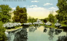
Miller Park is located at 2707 Redick Avenue in North Omaha, Nebraska. Bounded by Redick and Kansas Avenues on the north and south and 24th and 30th Streets on the east and west, respectively, the park was added to the city of Omaha in 1891.
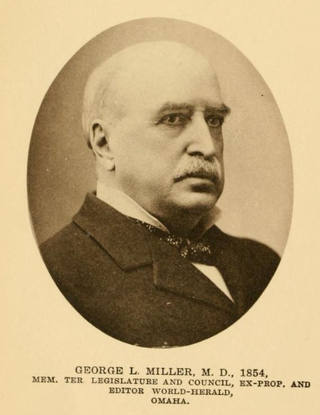
George Lorin Miller was an American pioneer physician, editor, politician, and land owner in Omaha, Nebraska. The founder of the Omaha Herald, which later became part of the Omaha World-Herald, Miller arrived in Omaha in 1854, the year the city was founded. He also promoted Omaha as the route of the First transcontinental railroad and the Trans-Mississippi and International Exposition in Omaha in 1898.
The Omaha Driving Park, later called Sunset Driving Park, was located in North Omaha, Nebraska, United States. It was an important recreational and sports venue in the history of Omaha.
Significant events in the history of Omaha, Nebraska, include social, political, cultural, and economic activities.

