Related Research Articles
Florence is a neighborhood in Omaha, Nebraska, United States on the city's north end and originally one of the oldest cities in Nebraska. It was incorporated by the Nebraska Territorial Legislature on March 10, 1857. The site of Winter Quarters for Mormon migrants traveling west, it has the oldest cemetery for people of European descent and oldest standing gristmill in Nebraska. Florence was the site of an illegal territorial legislature in 1858. Given the high concentration of National Register of Historic Places in the neighborhood, it is regarded as "the historic front door to Omaha as well as the state."

Fort Omaha, originally known as Sherman Barracks and then Omaha Barracks, is an Indian War-era United States Army supply installation. Located at 5730 North 30th Street, with the entrance at North 30th and Fort Streets in modern-day North Omaha, Nebraska, the facility is primarily occupied by the Metropolitan Community College. A Navy Operational Support Center and Marine Corps Reserve unit, along with an Army Reserve unit occupy the periphery of the 82.5 acres (33.4 ha) fort. The government deeded all but four parcels of the land to the Metropolitan Community College in 1974.

The Great Plains Black History Museum currently resides on the first floor of the historic Jewell Building in North Omaha, Nebraska. It was formerly located at 2213 Lake Street in the Near North Side neighborhood in North Omaha. It was housed in the Webster Telephone Exchange Building, which is listed on the National Register of Historic Places. A nationally renowned institution for more than 40 years, the museum includes more than 100,000 periodicals, manuscripts, photographs and research materials. The museum currently conducts programs and presents exhibits throughout Omaha, the State of Nebraska, regionally and nationally upon request.

The Durham Museum is located at 801 South 10th Street in downtown Omaha, Nebraska. The museum is dedicated to preserving and displaying the history of the United States' western region. The museum is housed in Omaha's former Union Station.
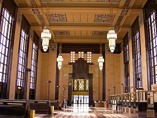
The Union Station, at 801 South 10th Street in Omaha, Nebraska, known also as Union Passenger Terminal, is "one of the finest examples of Art Deco architecture in the Midwest". Designated an Omaha Landmark in 1978, it was listed as "Union Passenger Terminal" on the National Register of Historic Places in 1971, and was designated a National Historic Landmark in 2016. The Union Station is also a contributing property to the Omaha Rail and Commerce Historic District. It was the Union Pacific's first Art Deco railroad station, and the completion of the terminal "firmly established Omaha as an important railroad terminus in the Midwest".

The Bemis Park Landmark Heritage District is located in North Omaha, Nebraska. Situated from Cuming Street to Hawthorne Avenue, Glenwood Avenue to 33rd Street, Bemis Park was annexed into Omaha in 1887, and developed from 1889-1922. The district was designated an Omaha Landmark in 1983.
The Miller Park neighborhood in North Omaha, Nebraska is a historically significant community housing a historic district and several notable historic places. It is located between Sorenson Parkway on the south and Redick Avenue on the north, Florence Boulevard on the east and 30th Street on the west. The Minne Lusa neighborhood borders on the north, and the Saratoga neighborhood is on the south. Fort Omaha borders the neighborhood on the west. Miller Park is the namesake park in the neighborhood, as well as the Miller Park Elementary School. In 2017, the Miller Park/Minne Lusa area was ranked as having the 2nd highest rate of homicides and other violent crimes out of 81 Omaha neighborhoods.
Scriptown was the name of the first subdivision in the history of Omaha, which at the time was located in Nebraska Territory. It was called "Scriptown" because scrip was used as payment, similar to how a company would pay employees when regular money was unavailable. Its original survey placed the location from the Missouri River to North 30th Street, Cuming to Fort Street.
The Florence Firehouse is located at 8415 North 29th Street in the Florence neighborhood in the north end of Omaha, Nebraska. Built in 1888, it housed Florence Hose Company #1.

Little Bohemia, or Bohemian Town, is a historic neighborhood in Omaha, Nebraska. Starting in the 1880s, Czech immigrants settled in this highly concentrated area, also called "Praha" (Prague) or "Bohemian Town", bounded by South 10th Street on the east, South 16th Street on the west, Pierce Street on the north, and Martha Street on the south, with a commercial area went along South 13th and South 14th Streets, centered on William Street. It was located south of downtown, and directly west of Little Italy. A portion of the neighborhood along South 13th Street was listed on the National Register of Historic Places in 2020.

The Union Stockyards of Omaha, Nebraska, were founded in 1883 in South Omaha by the Union Stock Yards Company of Omaha. A fierce rival of Chicago's Union Stock Yards, the Omaha Union Stockyards were third in the United States for production by 1890. In 1947 they were second to Chicago in the world. Omaha overtook Chicago as the nation's largest livestock market and meat packing industry center in 1955, a title which it held onto until 1971. The 116-year-old institution closed in 1999. The Livestock Exchange Building was listed on the National Register of Historic Places in 1999.
Sheelytown was a historic ethnic neighborhood in South Omaha, Nebraska, USA with populations of Irish, Polish and other first generation immigrants. Located north of the Union Stockyards, it was bounded by Edward Creighton Boulevard on the north, Vinton Street on the south, South 24th Street to the east, and 35th Street to the west. Sheelytown was named for the Sheely Brothers Packing Houses that were located in the area. Sheelytown was annexed by Omaha in 1887. The Omaha Quartermaster Depot was built just east of the community across the Union Pacific tracks.
The Florence Water Works is located along John J. Pershing Drive in the Florence neighborhood of Omaha, Nebraska. Home of the Minne Lusa Pumping Station, the Water Works has provided water throughout the city of Omaha since 1880.
Lincoln Boulevard in Omaha, Nebraska was built in the early 1890s as part of the city's boulevard system under control of the Board of Park Commissioners. It runs through the Bemis Park neighborhood west-east from Mercer Boulevard to its end at North 29 Street; it then reemerges immediately north of Dodge Street, where it intersects with Turner Boulevard.
The Florence School is located at 7902 North 36th Street in the Florence neighborhood of north Omaha, Nebraska, United States. The first school in the Florence area was built in the 1840s, in what was then called Cutler's Park by Mormon pioneers. The present-day Florence Elementary School was started in the late 1850s after the town of Florence was founded.
Heartland of America Park is a public park located at 800 Douglas Street in downtown Omaha, Nebraska. It has been closed for renovations since 2019 and will not reopen until 2023. The 31-acre (130,000 m2) park is situated between Interstate 80 and the Missouri River, and is adjacent to Gene Leahy Mall and the Old Market and connects to Lewis & Clark Landing. Where the park sits has been the site of exploration, expansion and now, recreation. Lewis and Clark reportedly discovered conspicuous earthen mounds when they explored the location in 1804. Historians speculate the mounds may have been natural or the remains of an Otoe village. Opened in 1990, the park was built on recovered after the controversial demolition of the Jobbers Canyon Historic District. The area, filled with warehouses dating to the 1870s, was integral to the growth and development of Omaha.

The Union Pacific Railroad Omaha Shops Facility was a 100-acre (0.40 km2) shop for the trains of the Union Pacific located at North 9th and Webster in Downtown Omaha. With the first locomotives arriving in 1865, it took until the 1950s for the facility to become the major overhaul and maintenance facility for the railroad. This lasted until 1988 when UP moved most of the operations out-of-state. Demolition began soon afterwards.
The Florence Park is a city-owned public park in the Florence neighborhood of North Omaha, Nebraska. Located at North 30th and State Streets, it is the oldest park and the oldest original town square in Nebraska, having been created by the original pioneers of the area in the 1840s. In the southern end of the park there is an official Nebraska State Historical Marker that tells the story of Winter Quarters, the 1840s settlement in the area. For many years a large cottonwood tree in the park featured a plaque that proclaimed its usage by Brigham Young as a hitching post.
Gibson Bend of the Missouri River is a meander located in Pottawattamie County, Iowa and Douglas County, Nebraska, located at 41°11′15″N95°55′15″W. The Gibson neighborhood is a community area in Omaha, Nebraska abutting the Gibson Bend.
The Sarpy County Museum is located at 2402 Clay St in Bellevue, Nebraska. The museum holds a collection of artifacts and historical resources, covering the history of Sarpy County, Nebraska, including Bellevue, Gretna, La Vista, Papillion, and Springfield. The museum includes the history of fur traders and missionaries, period rooms, early agricultural pursuits, and a scale model of Fort Crook, which later became Offutt Air Force Base.
References
- ↑ (nd) Florence Depot. Historic Florence Foundation. Retrieved 6/17/07.
- ↑ "A History of the Florence Depot" by Adam Fletcher Sasse for NorthOmahaHistory.com. (August 2, 2022).
- ↑ Roberts, K. (2003) "A stroll around friendly Florence". Omaha World-Herald. 9/23/03. Retrieved 6/18/07. [ dead link ]