The Omaha Southern Railway was a subsidiary corporation owned by the Missouri Pacific Railroad Company. In 1891, the railroad bought a plot of land south of Plattsmouth, Nebraska, that caused speculation in the town about the location of a railyard there. [1] The railroad was also subject to a period study of subsidies it received from local and state governments. [2]
Nebraska is a landlocked state in the Midwestern region of the United States. It borders South Dakota to the north; Iowa to the east and Missouri to the southeast, both across the Missouri River; Kansas to the south; Colorado to the southwest; and Wyoming to the west. Nebraska is the 16th-largest state by land area, with just over 77,220 square miles (200,000 km2). With a population of over 1.9 million, it is the 38th-most populous state and the eighth-least densely populated. Its capital is Lincoln, and its most populous city is Omaha, which is on the Missouri River. Nebraska was admitted into the United States in 1867, two years after the end of the American Civil War. The Nebraska Legislature is unlike any other American legislature in that it is unicameral, and its members are elected without any official reference to political party affiliation. Nebraska is one of only two states that divide electoral college votes by district, and is not winner-take-all.

Omaha is the most populous city in the U.S. state of Nebraska and the county seat of Douglas County. It is located in the Midwestern United States along the Missouri River, about 10 mi (15 km) north of the mouth of the Platte River. The nation's 40th-most populous city, Omaha had a population of 486,051 as of the 2020 census. It is the anchor of the eight-county Omaha–Council Bluffs metropolitan area, which extends into Iowa and is the 58th-largest metro area in the United States, with a population of 967,604. Furthermore, the greater Omaha–Council Bluffs–Fremont combined statistical area had 1,004,771 residents in 2020.

Cass County is a county in the U.S. state of Nebraska. As of the 2020 United States Census, the population was 26,598. Its county seat and largest city is Plattsmouth. The county was formed in 1855, and was named for General Lewis Cass, an American military officer, politician, and statesman.

Plattsmouth is a city and county seat of Cass County, Nebraska, United States. The population was 6,620 at the 2020 census.
Union Pacific Corporation is a publicly traded railroad holding company. It is incorporated in Utah and is headquartered in Omaha, Nebraska. Its only operating subsidiary is Union Pacific Railroad. Along with BNSF Railway, owned by Berkshire Hathaway, the companies have a near-duopoly on freight railroad transportation west of the Mississippi River.
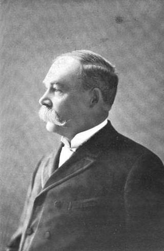
James Edward Boyd was an Irish-born American businessman and politician in early Omaha, Nebraska. The founder of Boyd's Packing House and Boyd's Theater and Opera House, he served as the Mayor of Omaha from 1881 to 1883 and from 1885 to 1887, and as the seventh Governor of the state of Nebraska in 1891 and from 1892 – 1893.

The Chicago, St. Paul, Minneapolis and Omaha Railway or Omaha Road was a railroad in the U.S. states of Nebraska, Iowa, Minnesota, Wisconsin and South Dakota. It was incorporated in 1880 as a consolidation of the Chicago, St. Paul and Minneapolis Railway and the North Wisconsin Railway. The Chicago and North Western Railway (C&NW) gained control in 1882. The C&NW leased the Omaha Road in 1957 and merged the company into itself in 1972. Portions of the C. St. P. M. and O. are part of the Union Pacific Railroad network. This includes main lines from Wyeville, Wisconsin, to St. Paul, Minnesota, and St. Paul to Sioux City, Iowa.

The Burlington and Missouri River Railroad (B&MR) or sometimes (B&M) was an American railroad company incorporated in Iowa in 1852, with headquarters in Omaha, Nebraska. It was developed to build a railroad across the state of Iowa and began operations in 1856. It was acquired by the Chicago, Burlington and Quincy Railroad in 1872, and kept serving as its subsidiary.
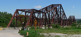
The Plattsmouth Bridge is a truss bridge over the Missouri River connecting Cass County, Nebraska, and Mills County, Iowa at Plattsmouth, Nebraska. Until 2014, it carried U.S. Highway 34 across the river.
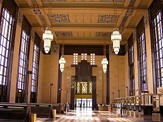
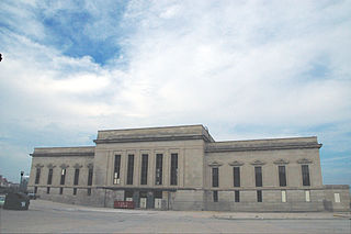
The Union Station, at 801 South 10th Street in Omaha, Nebraska, known also as Union Passenger Terminal, is "one of the finest examples of Art Deco architecture in the Midwest". Designated an Omaha Landmark in 1978, it was listed as "Union Passenger Terminal" on the National Register of Historic Places in 1971, and was designated a National Historic Landmark in 2016. The Union Station is also a contributing property to the Omaha Rail and Commerce Historic District. It was the Union Pacific's first Art Deco railroad station, and the completion of the terminal "firmly established Omaha as an important railroad terminus in the Midwest".

The Naomi Institute, also known as the Rock Bluff School, is located in the ghost town of Rock Bluff, Nebraska, three miles east of Murray. It was one of the earliest higher education institutions in Nebraska, founded in 1870 as a pioneer college. The building was listed on the National Register of Historic Places in 1977.

Transportation in Omaha, Nebraska, includes most major modes, such as pedestrian, bicycle, automobile, bus, train and airplane. While early transportation consisted of ferries, stagecoaches, steamboats, street railroads, and railroads, the city's transportation systems have evolved to include the Interstate Highway System, parklike boulevards and a variety of bicycle and pedestrian trails. The historic head of several important emigrant trails and the First transcontinental railroad, its center as a national transportation hub earned Omaha the nickname "Gate City of the West" as early as the 1860s.
Railroads in Omaha, Nebraska, have been integral to the growth and development of the city, the state of Nebraska, the Western United States and the entire United States. The convergence of many railroad forces upon the city was by happenstance and synergy, as none of the Omaha leaders had a comprehensive strategy for bringing railroads to the city.

U.S. Route 75 was a part of the United States Numbered Highway System that runs for 1,239 miles (1,994 km) from Dallas, Texas to Kittson County, Minnesota where it ends just short of the Canada–United States border. Within the State of Nebraska it is a state highway that enters Nebraska on the Kansas state line about 9 miles (14 km) south of Dawson and travels north across the extreme eastern portion of the state, to the Nebraska–Iowa border in South Sioux City where it crosses the Missouri River along a concurrency with Interstate 129. The northern 210 miles (340 km) of the route generally travels parallel to the Missouri River. The 87.32-mile (140.53 km) section between the I-680 interchange in Omaha and the Interstate 129 interchange is designated the Lewis & Clark Scenic Byway, one of nine scenic byways in the state.
Significant events in the history of Omaha, Nebraska, include social, political, cultural, and economic activities.

U.S. Highway 34 (US 34) is a United States Highway that runs across the southern third of Iowa. It begins on a bridge over the Missouri River west of Glenwood and travels east where it meets Interstate 29 (I-29) and US 275. Through southwestern Iowa, the highway is, for the most part, a two-lane rural road with at-grade intersections; there are interchanges with US 59 near Emerson and US 71 near Stanton and Villisca. At Osceola, the highway intersects I-35 and US 69. Just east of Ottumwa, where the road meets US 63, the road joins the four-lane Iowa 163 for the remainder of its trek through the state. At Mount Pleasant, it overlaps US 218 and Iowa 27, the Avenue of the Saints Highway. From there, the road heads to the southeast where it crosses the Mississippi River on the Great River Bridge at Burlington.
Bill Wimmer is an American railroad executive who worked in operations for the Union Pacific Railroad.

The Omaha & Southern Interurban Railway Company built and operated around 1907 an interurban railway from South Omaha, Nebraska, to Belleview College and Fort Crook, six miles (9.7 km) south.

The California Zephyr is a long-distance passenger train operated by Amtrak between Chicago and the San Francisco Bay Area, via Omaha, Denver, Salt Lake City, and Reno. At 2,438 miles (3,924 km), it is Amtrak's longest daily route, and second-longest overall after the Texas Eagle's triweekly continuation from San Antonio to Los Angeles, with travel time between the termini taking approximately 511⁄2 hours. Amtrak claims the route as one of its most scenic, with views of the upper Colorado River valley in the Rocky Mountains, and the Sierra Nevada. The modern train is the second iteration of a train named California Zephyr; the original train was privately operated and ran on a different route through Nevada and California.