
Winter Quarters was an encampment formed by approximately 2,500 members of The Church of Jesus Christ of Latter-day Saints as they waited during the winter of 1846–47 for better conditions for their trek westward. It followed a preliminary tent settlement some 3½ miles west at Cutler's Park. Members of the LDS faith built more than 800 cabins at the Winter Quarters settlement. Located in present-day North Omaha overlooking the Missouri River, the settlement remained populated until 1848.

The Fort Calhoun Nuclear Generating Station is a shut-down nuclear power plant located on 660 acres (2.7 km2) between Fort Calhoun, and Blair, Nebraska adjacent to the Missouri River between mile markers 645.6 and 646.0. The utility has an easement for another 580 acres (2.3 km2) which is maintained in a natural state. The power plant is owned by the Omaha Public Power District of Omaha, Nebraska. When operational, the plant accounted for 25 percent of OPPD's net generation capabilities.

Cabanne's Trading Post was established in 1822 by the American Fur Company as Fort Robidoux near present-day Dodge Park in North Omaha, Nebraska, United States. It was named for the influential fur trapper Joseph Robidoux. Soon after it was opened, the post was called the French Company or Cabanné's Post, for the ancestry and name of its operator, Jean Pierre Cabanné, who was born and raised among the French community of St. Louis, Missouri.
Florence is a neighborhood in Omaha, Nebraska, United States on the city's north end and originally one of the oldest cities in Nebraska. It was incorporated by the Nebraska Territorial Legislature on March 10, 1857. The site of Winter Quarters for Mormon migrants traveling west, it has the oldest cemetery for people of European descent and oldest standing gristmill in Nebraska. Florence was the site of an illegal territorial legislature in 1858. Given the high concentration of National Register of Historic Places in the neighborhood, it is regarded as "the historic front door to Omaha as well as the state."
East Omaha is a geographically designated community located in Omaha, Nebraska. Located three miles (5 km) from downtown Omaha, East Omaha is the site of Eppley Airfield, Omaha's main airport, and Carter Lake. This area was Omaha's first annexation, joining the city in 1854.
The history of North Omaha, Nebraska includes wildcat banks, ethnic enclaves, race riots and social change spanning over 200 years. With a recorded history that pre-dates the rest of the city, North Omaha has roots back to 1812 with the founding of Fort Lisa. It includes the Mormon settlement of Cutler's Park and Winter Quarters in 1846, a lynching before the turn-of-the-twentieth-century, the thriving 24th Street community of the 1920s, the bustling development of the African-American community through the 1950s, a series of riots in the 1960s, and redevelopment in the late 20th and early 21st century.
The neighborhoods of Omaha are a diverse collection of community areas and specific enclaves. They are spread throughout the Omaha metro area, and are all on the Nebraska side of the Missouri River.

Culture in North Omaha, Nebraska, the north end of Omaha, is defined by socioeconomic, racial, ethnic and political diversity among its residents. The neighborhood's culture is largely influenced by its predominantly African American community.

Omaha Public Power District, or OPPD, is a public electric utility in the state of Nebraska. It is a publicly owned electric utility in the United States, serving more than 855,000 people in Omaha and 13 surrounding counties in southeast Nebraska. OPPD was formed in 1946 as a political subdivision of the State of Nebraska, taking over the operations of Nebraska Power Company. A publicly elected eight-member Board of Directors sets rates and policies.
The Miller Park neighborhood in North Omaha, Nebraska is a historically significant community housing a historic district and several notable historic places. It is located between Sorenson Parkway on the south and Redick Avenue on the north, Florence Boulevard on the east and 30th Street on the west. The Minne Lusa neighborhood borders on the north, and the Saratoga neighborhood is on the south. Fort Omaha borders the neighborhood on the west. Miller Park is the namesake park in the neighborhood, as well as the Miller Park Elementary School. In 2017, the Miller Park/Minne Lusa area was ranked as having the 2nd highest rate of homicides and other violent crimes out of 81 Omaha neighborhoods.

The Minne Lusa Residential Historic District is located in North Omaha, Nebraska. It is included on the National Register of Historic Places. According to the National Park Service, it is an "example of a substantial, affordable single-family residential development within the city limits that was platted, developed and constructed by a single firm between 1915 and 1941." The neighborhood is filled with bungalows, Craftsman, and other styles that were popular in the era. There are 540 properties in the neighborhood that contribute to the historic district, the other 167 do not. Minne Lusa Boulevard is a contributing structure.
The Florence Depot at 9000 North 30th Street in the Florence community of Omaha, Nebraska. Originally built in 1887 at 28th and Grebe in downtown Florence, the Depot closed in 1966. It was moved to its present location in 1971, and has been used as a historical railroad museum since 1976.
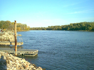
N.P. Dodge Memorial Park, or simply Dodge Park, is a recreational area located at 11001 John J. Pershing Drive in North Omaha, Nebraska, United States. Located on the Missouri River, the park provides fishing, water skiing, and boating, as well as hiking throughout its riparian forests. Baseball fields, soccer fields, horseshoe pits, and tennis courts are included for sporting events. There is a picnic area, pavilions, historical monuments, and a campground.

The Metropolitan Utilities District, or M.U.D., is the political subdivision and public corporation of the U.S. State of Nebraska that operates the drinking water and natural gas systems for Omaha, Nebraska and surrounding areas. M.U.D. is the only metropolitan utilities district in the State of Nebraska, and the fifth largest public natural gas utility in the U.S.

Transportation in Omaha, Nebraska, includes most major modes, such as pedestrian, bicycle, automobile, bus, train and airplane. While early transportation consisted of ferries, stagecoaches, steamboats, street railroads, and railroads, the city's transportation systems have evolved to include the Interstate Highway System, parklike boulevards and a variety of bicycle and pedestrian trails. The historic head of several important emigrant trails and the First Transcontinental Railroad, its center as a national transportation hub earned Omaha the nickname "Gate City of the West" as early as the 1860s.
Mendelssohn, Fisher and Lawrie was a significant architecture firm in early Omaha, Nebraska. Fisher & Lawrie continued. A number of their works are listed on the National Register of Historic Places.
North 30th Street is a two-way street that runs south–north in the North Omaha area of Omaha, Nebraska. With the street beginning at Dodge Street, historically significant sections include those from Dodge to Lake Street, from Fort Street to Laurel Avenue, and from Weber to Bondesson Streets.
Salem Baptist Church is located at 3131 Lake Street in north Omaha, Nebraska, United States. Founded in 1922, it has played important roles in the history of African Americans in Omaha, and in the city's religious community. Church leadership has impacted the city in a variety of ways, with long-time pastor Rev. J.C. Wade being recognized in the Congressional Record in 2000, and having an area post office named after him.
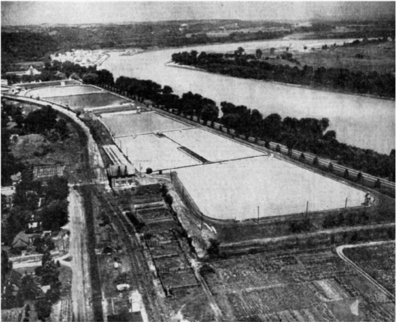
The Minne Lusa Pumping Station was located along John J. Pershing Drive in the Florence neighborhood of North Omaha, Nebraska. The station, which was surrounded by settling basins, was the main source for pumping, filtering, and distributing Missouri River water throughout the City of Omaha. The station was the namesake of the Minne Lusa neighborhood located immediately to the south.
The Walnut Hill Pumping Station, located in the Walnut Hill neighborhood, is part of the Metropolitan Utilities District water system serving the City of Omaha, Nebraska. It occupies four square blocks between 38th and 40th Streets, from Hamilton to Nicholas Streets.

