Related Research Articles
Florence is a neighborhood in Omaha, Nebraska, United States on the city's north end and originally one of the oldest cities in Nebraska. It was incorporated by the Nebraska Territorial Legislature on March 10, 1857. The site of Winter Quarters for Mormon migrants traveling west, it has the oldest cemetery for people of European descent and oldest standing gristmill in Nebraska. Florence was the site of an illegal territorial legislature in 1858. Given the high concentration of National Register of Historic Places in the neighborhood, it is regarded as "the historic front door to Omaha as well as the state."

The Bemis Park Landmark Heritage District is located in North Omaha, Nebraska. Situated from Cuming Street to Hawthorne Avenue, Glenwood Avenue to 33rd Street, Bemis Park was annexed into Omaha in 1887, and developed from 1889 to 1922. The district was designated an Omaha Landmark in 1983.
The Near North Side of Omaha, Nebraska is the neighborhood immediately north of downtown. It forms the nucleus of the city's historic African-American community, and its name is often synonymous with the entire North Omaha area. Originally established immediately after Omaha was founded in 1854, the Near North Side was once confined to the area around Dodge Street and North 7th Street. Eventually, it gravitated west and north, and today it is bordered by Cuming Street on the south, 30th on the west, 16th on the east, and Locust Street to the north. Countless momentous events in Omaha's African American community happened in the Near North Side, including the 1865 establishment of the first Black church in Omaha, St. John's AME; the 1892 election of the first African American state legislator, Dr. Matthew Ricketts; the 1897 hiring of the first Black teacher in Omaha, Ms. Lucy Gamble, the 1910 Jack Johnson riots, the Omaha race riot of 1919 that almost demolished the neighborhood and many other events.
The Kountze Place neighborhood of Omaha, Nebraska is a historically significant community on the city's north end. Today the neighborhood is home to several buildings and homes listed on the National Register of Historic Places. It is located between North 16th Avenue on the east to North 30th Street on the west; Locust Street on the south to Pratt Street on the north. Kountze Place was annexed into Omaha in 1887. The neighborhood was built as a suburban middle and upper middle class enclave for doctors, lawyers, successful businessmen and other professional workers.
The Miller Park neighborhood in North Omaha, Nebraska, is a historically significant community housing a historic district and several notable historic places. It is located between Sorenson Parkway on the south and Redick Avenue on the north, Florence Boulevard on the east and 30th Street on the west. The Minne Lusa neighborhood borders on the north, and the Saratoga neighborhood is on the south. Fort Omaha borders the neighborhood on the west. Miller Park is the namesake park in the neighborhood, as well as the Miller Park Elementary School. In 2017, the Miller Park/Minne Lusa area was ranked as having the 2nd highest rate of homicides and other violent crimes out of 81 Omaha neighborhoods.
Scriptown was the name of the first subdivision in the history of Omaha, which at the time was located in Nebraska Territory. It was called "Scriptown" because scrip was used as payment, similar to how a company would pay employees when regular money was unavailable. Its original survey placed the location from the Missouri River to North 30th Street, Cuming to Fort Street.
Little Italy is a neighborhood in Omaha, Nebraska which served as the historic home to Omahans of Italian ancestry. It was the source of many laborers for the Union Pacific railroad, much of Omaha's bootlegging during Prohibition and the Santa Lucia Procession, which started in 1924 and continues annually.

Little Bohemia, or Bohemian Town, is a historic neighborhood in Omaha, Nebraska. Starting in the 1880s, Czech immigrants settled in this highly concentrated area, also called "Praha" (Prague) or "Bohemian Town", bounded by South 10th Street on the east, South 16th Street on the west, Pierce Street on the north, and Martha Street on the south, with a commercial area went along South 13th and South 14th Streets, centered on William Street. It was located south of downtown, and directly west of Little Italy. A portion of the neighborhood along South 13th Street was listed on the National Register of Historic Places in 2020.
The Florence Depot at 9000 North 30th Street in the Florence community of Omaha, Nebraska. Originally built in 1887 at 28th and Grebe in downtown Florence, the Depot closed in 1966. It was moved to its present location in 1971, and has been used as a historical railroad museum since 1976.

The Union Stockyards of Omaha, Nebraska, were founded in 1883 in South Omaha by the Union Stock Yards Company of Omaha. A fierce rival of Chicago's Union Stock Yards, the Omaha Union Stockyards were third in the United States for production by 1890. In 1947 they were second to Chicago in the world. Omaha overtook Chicago as the nation's largest livestock market and meat packing industry center in 1955, a title which it held onto until 1971. The 116-year-old institution closed in 1999. The Livestock Exchange Building was listed on the National Register of Historic Places in 1999.
The Florence Water Works is located along John J. Pershing Drive in the Florence neighborhood of Omaha, Nebraska. Home of the Minne Lusa Pumping Station, the Water Works has provided water throughout the city of Omaha since 1880.
Zion Baptist Church is located at 2215 Grant Street in the Near North Side neighborhood of Omaha, Nebraska. The congregation is among the oldest in Nebraska, and has been instrumental for responding to much of the racial tension in Omaha.
The Florence School is located at 7902 North 36th Street in the Florence neighborhood of north Omaha, Nebraska, United States. The first school in the Florence area was built in the 1840s, in what was then called Cutler's Park by Mormon pioneers. The present-day Florence Elementary School was started in the late 1850s after the town of Florence was founded.
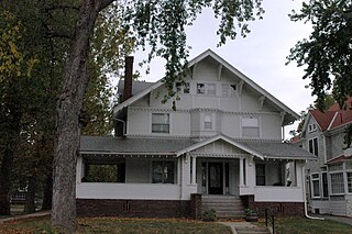
The Orchard Hill is a neighborhood in North Omaha, Nebraska. One of the oldest neighborhoods in the city, Orchard Hill is home to some of the city's oldest homes. The neighborhood's boundaries are Hamilton Street on the south, Blondo Street on the north, 36th Street on the east and the Omaha Belt Line on the west. The John A. Creighton Boulevard runs through the eastern part of the neighborhood.

The Benson City Hall and Fire Station, now known as the Benson Community Center, is located at 6008 Maple Street in the Benson neighborhood of Omaha, Nebraska. It was built in 1915, shortly before Benson's annexation by Omaha.
The Dundee City Hall and Fire Station was located at 4921 Underwood Avenue in the present-day Dundee neighborhood of Omaha, Nebraska.
The Hose Station No. 7 is located along a busy thoroughfare in a light industrial area of the west end of Davenport, Iowa, United States. It was listed on the National Register of Historic Places in 1983.

Davenport Hose Station No. 3 is located in a commercial area on the east side of Davenport, Iowa, United States. It has been listed on the National Register of Historic Places since 1984. The building is one of two historic former fire stations on the east side that are still in existence. The other one is Hose Station No. 4 in the Village of East Davenport.
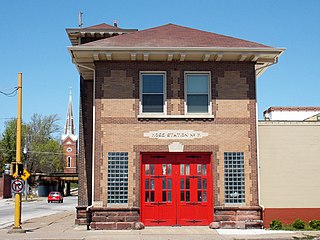
The Omaha Fire Department Hose Company building is located at 999 North 16th Street in Omaha, Nebraska, United States. The former home of Omaha Fire Department's hose company number 4 and designed by German-born architect Joseph P. Guth and built in 1913 by Dutchman Peter Kiewit & Sons, the building is now unoccupied. Charles A. Salter was the chief of the fire department at the time.
References
- ↑ (nd) Florence Firehouse. Retrieved 6/11/07.
- ↑ "Florence Firehouse". Archived from the original on 15 August 2007. Retrieved 11 June 2007.