
The Territory of Nebraska was an organized incorporated territory of the United States that existed from May 30, 1854, until March 1, 1867, when the final extent of the territory was admitted to the Union as the State of Nebraska. The Nebraska Territory was created by the Kansas–Nebraska Act of 1854. The territorial capital was Omaha. The territory encompassed areas of what is today Nebraska, Wyoming, South Dakota, North Dakota, Colorado, and Montana.

Winter Quarters was an encampment formed by approximately 2,500 members of The Church of Jesus Christ of Latter-day Saints as they waited during the winter of 1846–47 for better conditions for their trek westward. It followed a preliminary tent settlement some 3½ miles west at Cutler's Park. Members of the LDS faith built more than 800 cabins at the Winter Quarters settlement. Located in present-day North Omaha overlooking the Missouri River, the settlement remained populated until 1848.

North Omaha is a community area in Omaha, Nebraska, in the United States. It is bordered by Cuming and Dodge Streets on the south, Interstate 680 on the north, North 72nd Street on the west and the Missouri River and Carter Lake, Iowa on the east, as defined by the University of Nebraska at Omaha and the Omaha Chamber of Commerce.

Cabanne's Trading Post was established in 1822 by the American Fur Company as Fort Robidoux near present-day Dodge Park in North Omaha, Nebraska, United States. It was named for the influential fur trapper Joseph Robidoux. Soon after it was opened, the post was called the French Company or Cabanné's Post, for the ancestry and name of its operator, Jean Pierre Cabanné, who was born and raised among the French community of St. Louis, Missouri.
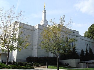
The Winter Quarters Nebraska Temple is the 104th operating temple of The Church of Jesus Christ of Latter-day Saints. It is located in Florence, now a neighborhood of Omaha, Nebraska, USA, and formerly an independent city.

The Mormon Bridge are two cantilever bridges that cross the Missouri River connecting Pottawattamie County, Iowa with Florence in the north end of Omaha, Nebraska via Interstate 680 (Iowa-Nebraska). The bridge is officially called the Mormon Pioneer Memorial Bridge due to its location on the historic Mormon Trail, which passed nearby.
Florence is a neighborhood in Omaha, Nebraska, United States on the city's north end and originally one of the oldest cities in Nebraska. It was incorporated by the Nebraska Territorial Legislature on March 10, 1857. The site of Winter Quarters for Mormon migrants traveling west, it has the oldest cemetery for people of European descent and oldest standing gristmill in Nebraska. Florence was the site of an illegal territorial legislature in 1858. Given the high concentration of National Register of Historic Places in the neighborhood, it is regarded as "the historic front door to Omaha as well as the state."
Fort Lisa (1812–1823) was established in 1812 in what is now North Omaha in Omaha, Nebraska by famed fur trader Manuel Lisa and the Missouri Fur Company, which was based in Saint Louis. The fort was associated with several firsts in Nebraska history: Lisa was the first European farmer in Nebraska; it was the first settlement by American citizens set up in the then-recent Louisiana Purchase; Lisa's wife was the first woman resident of European descent in Nebraska; and the first steamboat to navigate Nebraska waters, the Western Engineer, arrived at Fort Lisa in September 1819.
Saratoga Springs, Nebraska Territory, or Saratoga, was a boom and bust town founded in 1856 that throve for several years. During its short period of influence the town grew quickly, outpacing other local settlements in the area including Omaha and Florence, and briefly considered as a candidate for the Nebraska Territorial capitol. Saratoga was annexed into Omaha in 1887, and has been regarded a neighborhood in North Omaha since then.

The history of Omaha, Nebraska, began before the settlement of the city, with speculators from neighboring Council Bluffs, Iowa staking land across the Missouri River illegally as early as the 1840s. When it was legal to claim land in Indian Country, William D. Brown was operating the Lone Tree Ferry to bring settlers from Council Bluffs to Omaha. A treaty with the Omaha Tribe allowed the creation of the Nebraska Territory, and Omaha City was founded on July 4, 1854. With early settlement came claim jumpers and squatters, and the formation of a vigilante law group called the Omaha Claim Club, which was one of many claim clubs across the Midwest. During this period many of the city's founding fathers received lots in Scriptown, which was made possible by the actions of the Omaha Claim Club. The club's violent actions led to the U.S. Supreme Court trial, Baker v. Morton, which led to the end of the organization.
The Miller Park neighborhood in North Omaha, Nebraska is a historically significant community housing a historic district and several notable historic places. It is located between Sorenson Parkway on the south and Redick Avenue on the north, Florence Boulevard on the east and 30th Street on the west. The Minne Lusa neighborhood borders on the north, and the Saratoga neighborhood is on the south. Fort Omaha borders the neighborhood on the west. Miller Park is the namesake park in the neighborhood, as well as the Miller Park Elementary School. In 2017, the Miller Park/Minne Lusa area was ranked as having the 2nd highest rate of homicides and other violent crimes out of 81 Omaha neighborhoods.

The Mormon Pioneer Cemetery is located at 3300 State Street in present-day Florence at the north end of Omaha, Nebraska. The Cemetery is the burial site of hundreds of Mormon pioneers who lived in Winter Quarters, a temporary settlement that lasted from 1846 to 1848 as the settlers moved to Salt Lake City, Utah. It was designated a landmark by the City of Omaha in 1990.
The Florence Depot at 9000 North 30th Street in the Florence community of Omaha, Nebraska. Originally built in 1887 at 28th and Grebe in downtown Florence, the Depot closed in 1966. It was moved to its present location in 1971, and has been used as a historical railroad museum since 1976.
The Potter's Field Cemetery in Omaha, Nebraska, United States is located on a 5-acre (20,000 m2) plot of land at 5000 Young Street near the intersections of Young Street and Mormon Bridge Road. Like all Potter's Fields, it was used to bury poor people or people with no known identity from across the Omaha area. The cemetery was active from 1887 to 1957.
Forest Lawn Memorial Park, also known as Forest Lawn Cemetery, is located at 7909 Mormon Bridge Road in North Omaha, Nebraska. It was established in 1885 when the Forest Lawn Cemetery Association was donated 100 acres (0.40 km2) in northwest of the city. In 1886, the first interment in the cemetery was the donor of the land, John H. Brackin. Forest Lawn is Omaha's largest cemetery and the burial location of many of Omaha's second generation of leadership.

Transportation in Omaha, Nebraska, includes most major modes, such as pedestrian, bicycle, automobile, bus, train and airplane. While early transportation consisted of ferries, stagecoaches, steamboats, street railroads, and railroads, the city's transportation systems have evolved to include the Interstate Highway System, parklike boulevards and a variety of bicycle and pedestrian trails. The historic head of several important emigrant trails and the First Transcontinental Railroad, its center as a national transportation hub earned Omaha the nickname "Gate City of the West" as early as the 1860s.
The Florence School is located at 7902 North 36th Street in the Florence neighborhood of north Omaha, Nebraska, United States. The first school in the Florence area was built in the 1840s, in what was then called Cutler's Park by Mormon pioneers. The present-day Florence Elementary School was started in the late 1850s after the town of Florence was founded.
Squatter's Row was a historic neighborhood in the downtown area of Omaha, Nebraska. It was an area between North 11th and North 13th Streets, from Nicholas to Locust Streets, behind the Storz Brewery. For more than 75 years this area was inhabited solely by squatters. A village of shacks built of materials salvaged from the Omaha city dump, the neighborhood included different enclaves such as Vinegar Flats, Blind Pig Alley, among others.
The Wilson Packing Plant was a division of the Wilson and Company meatpacking company located near South 27th and Y Streets in South Omaha, Nebraska. Founded in the 1890s, it closed in 1976. It occupied the area bounded by Washington Street, South 27th Street, W Street and South 30th Street. Located on the South Omaha Terminal Railway and next to the Omaha Stockyards, Wilson was regarded as one of the "Big Four" packing companies in Omaha.
The Danish people in Omaha, Nebraska, were a predominant ethnic group in the city in the 1920s, and were notable for that compared to other cities across the United States. Omaha, as well as its neighbor, Council Bluffs, had "major colonies of Danes for many years."
