
North Omaha is a community area in Omaha, Nebraska, in the United States. It is bordered by Cuming and Dodge Streets on the south, Interstate 680 on the north, North 72nd Street on the west and the Missouri River and Carter Lake, Iowa on the east, as defined by the University of Nebraska at Omaha and the Omaha Chamber of Commerce.
Florence is a present-day neighborhood in Omaha, Nebraska, United States on the city's north end and was one of the oldest cities in Nebraska before being annexed by Omaha. Given the high concentration of National Register of Historic Places in the neighborhood, it is acknowledged that "The historic Florence neighborhood was a city before Nebraska was officially a state," and is regarded as "the historic front door to Omaha as well as the state."
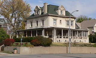
The Havens–Page House, also known as the T. C. Havens House, is a historic house built between 1900 and 1924 at 101 North 39th Street in the Gold Coast Historic District of Omaha, Nebraska. Listed on the National Register of Historic Places in 1982, this home is remarkable for its classical Georgian Revival architecture.
Midtown is a geographic area of Omaha, Nebraska that is a culturally, socially and economically important area of the city. It is home to major research centers, national corporations, several historic districts, and a number of historic residences.

Field Club is an affluent and historic neighborhood located in the Midtown region of Omaha, Nebraska. Roughly bounded by Pacific Street, 32nd Avenue, Center St., and 36th Street, the neighborhood was placed on the National Register of Historic Places as a historic district on November 15, 2000. Field Club is the location of dozens of historically significant homes in the Omaha area, including the Gerald R. Ford Birthsite and Gardens.
Morton Meadows is a historic neighborhood located in Midtown Omaha, Nebraska. The neighborhood lies between Center and Leavenworth Streets, from 42nd Street to Saddle Creek, and is sometimes referred to by its central boulevard, Twin Ridge. It is near the Dundee area, as well as the Gold Coast, Field Club and Country Club historic districts.

The George and Sarah Joslyn Home, is a mansion located at 3902 Davenport Street in the Gold Coast Historic District of Omaha, Nebraska, United States. Built in the Scottish Baronial style in 1903, the Castle was added to the National Register of Historic Places in 1972. It was designated as an Omaha landmark in 1979.

The Bemis Park Landmark Heritage District is located in North Omaha, Nebraska. Situated from Cuming Street to Hawthorne Avenue, Glenwood Avenue to 33rd Street, Bemis Park was annexed into Omaha in 1887, and developed from 1889 to 1922. The district was designated an Omaha Landmark in 1983.
The Near North Side of Omaha, Nebraska is the neighborhood immediately north of downtown. It forms the nucleus of the city's historic African-American community, and its name is often synonymous with the entire North Omaha area. Originally established immediately after Omaha was founded in 1854, the Near North Side was once confined to the area around Dodge Street and North 7th Street. Eventually, it gravitated west and north, and today it is bordered by Cuming Street on the south, 30th on the west, 16th on the east, and Locust Street to the north. Countless momentous events in Omaha's African American community happened in the Near North Side, including the 1865 establishment of the first Black church in Omaha, St. John's AME; the 1892 election of the first African American state legislator, Dr. Matthew Ricketts; the 1897 hiring of the first Black teacher in Omaha, Ms. Lucy Gamble, the 1910 Jack Johnson riots, the Omaha race riot of 1919 that almost demolished the neighborhood and many other events.
The Kountze Place neighborhood of Omaha, Nebraska is a historically significant community on the city's north end. Today the neighborhood is home to several buildings and homes listed on the National Register of Historic Places. It is located between North 16th Avenue on the east to North 30th Street on the west; Locust Street on the south to Pratt Street on the north. Kountze Place was annexed into Omaha in 1887. The neighborhood was built as a suburban middle and upper middle class enclave for doctors, lawyers, successful businessmen and other professional workers.
The Miller Park neighborhood in North Omaha, Nebraska, is a historically significant community housing a historic district and several notable historic places. It is located between Sorenson Parkway on the south and Redick Avenue on the north, Florence Boulevard on the east and 30th Street on the west. The Minne Lusa neighborhood borders on the north, and the Saratoga neighborhood is on the south. Fort Omaha borders the neighborhood on the west. Miller Park is the namesake park in the neighborhood, as well as the Miller Park Elementary School. In 2017, the Miller Park/Minne Lusa area was ranked as having the 2nd highest rate of homicides and other violent crimes out of 81 Omaha neighborhoods.
The Dahlman neighborhood is located south of downtown Omaha, Nebraska. One of the oldest neighborhoods in the city, it was originally platted in 1856. It was later named after "Cowboy" James Dahlman, an eight-term mayor of Omaha.
Gifford Park is a historic neighborhood in midtown Omaha, Nebraska. It is roughly bounded by the North Freeway on the east, North 38th Street on the west, Dodge Street on the south and Cuming Street on the north. Its namesake park was added to the City parks network in 1916. The neighborhood is bounded by several historic neighborhoods, including Bemis Park, Gold Coast, and the Near North Side.
Sheelytown was a historic ethnic neighborhood in South Omaha, Nebraska, USA with populations of Irish, Polish and other first generation immigrants. Located north of the Union Stockyards, it was bounded by Edward Creighton Boulevard on the north, Vinton Street on the south, South 24th Street to the east, and 35th Street to the west. Sheelytown was named for the Sheely Brothers Packing Houses that were located in the area. Sheelytown was annexed by Omaha in 1887. The Omaha Quartermaster Depot was built just east of the community across the Union Pacific tracks.

The Blackstone Hotel is a historic hotel located at 302 South 36th Street in the Blackstone neighborhood of the Midtown area in Omaha, Nebraska. Built in 1915, it was declared an Omaha Landmark in 1983 and listed on the National Register of Historic Places in 1985.

The Gottlieb Storz House is located in the Blackstone neighborhood of Midtown Omaha, Nebraska. Built in 1905 by Omaha beer magnate Gottlieb Storz, the mansion was designated an Omaha Landmark on December 21, 1982, and was listed in the National Register of Historic Places on August 7, 1974. It was included in the Gold Coast Historic District when the district was listed in the NRHP on March 14, 1997.
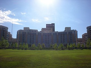
Midtown Crossing at Turner Park is a vibrant mixed-use development in midtown Omaha, featuring retail, office, residential spaces, and green areas. Renowned for its bustling local business scene and year-round community events, this 16-acre seven-building development hosts more than 30 retail and office tenants, 297 condominiums, 196 apartment units, and picturesque Turner Park.
South 10th Street is a two-way street that runs south-north from Downtown into South Omaha, Nebraska. Beginning at Dodge Street, South 10th Street passes Gene Leahy Mall and borders the ConAgra Campus and the Old Market. Its southern reaches are widely regarded as the heart of Little Italy, and further south it was the center of the Old Gold Coast neighborhood. There were several other historically ethnic communities, as well.

Old Gold Coast is a historic district in south Omaha, Nebraska. With South 10th Street as the central artery, the area was home to neighborhoods such as Little Italy and Forest Hill. The area is referred to as "old" because it was replaced in prominence in the late 19th century when a new district usurped its importance. This area south of downtown was generally bounded by Leavenworth Street on the north, Bancroft Street on the south, the Missouri River on the east, and South 16th Street on the west.
The West Farnam neighborhood or the Blackstone neighborhood in Omaha, Nebraska is located from Dodge Street on the north to Leavenworth Street on the south, Highway 75/Interstate 480 on the east to South 52nd Street on the west. In 1997, the Gold Coast Historic District was formed from the West Farnam neighborhood and the Park Place neighborhood, known today as Cathedral. Named for its principal thoroughfare, West Farnam was a prime real estate area in the first quarter of the 20th century. It is home to several historical landmarks, including houses, churches, and former hotels.


