A streetcar suburb is a residential community whose growth and development was strongly shaped by the use of streetcar lines as a primary means of transportation. Such suburbs developed in the United States in the years before the automobile, when the introduction of the electric trolley or streetcar allowed the nation’s burgeoning middle class to move beyond the central city’s borders. Early suburbs were served by horsecars, but by the late 19th century cable cars and electric streetcars, or trams, were used, allowing residences to be built farther away from the urban core of a city. Streetcar suburbs, usually called additions or extensions at the time, were the forerunner of today's suburbs in the United States and Canada. San Francisco's Western Addition is one of the best examples of streetcar suburbs before westward and southward expansion occurred.

The Dundee–Happy Hollow Historic District is located west of Midtown Omaha, Nebraska. It covers the area between Harney Street on the south, Hamilton Street on the north, Happy Hollow Boulevard on the west, and 46th Street on the east. The "heart" of Dundee is located at 50th and Underwood Avenue in Omaha, Nebraska, United States. It was founded in 1880 and annexed into the city in 1915. Dundee is home to Warren Buffett and nationally syndicated editorial cartoonist Jeff Koterba and was the hometown of filmmaker Alexander Payne. Actor Henry Fonda additionally lived in the Dundee neighborhood.
The history of Omaha, Nebraska, began before the settlement of the city, with speculators from neighboring Council Bluffs, Iowa staking land across the Missouri River illegally as early as the 1840s. When it was legal to claim land in Indian Country, William D. Brown was operating the Lone Tree Ferry to bring settlers from Council Bluffs to Omaha. A treaty with the Omaha Tribe allowed the creation of the Nebraska Territory, and Omaha City was founded on July 4, 1854. With early settlement came claim jumpers and squatters, and the formation of a vigilante law group called the Omaha Claim Club, which was one of many claim clubs across the Midwest. During this period many of the city's founding fathers received lots in Scriptown, which was made possible by the actions of the Omaha Claim Club. The club's violent actions were challenged successfully in a case ultimately decided by the U.S. Supreme Court, Baker v. Morton, which led to the end of the organization.
The neighborhoods of Omaha are a diverse collection of community areas and specific enclaves. They are spread throughout the Omaha metro area, and are all on the Nebraska side of the Missouri River.

St. John African Methodist Episcopal Church was the first church for African Americans in Nebraska, organized in North Omaha in 1867. It is located at 2402 North 22nd Street in the Near North Side neighborhood. The building is listed on the National Register of Historic Places. The building was constructed in the center of Omaha's North Side in the Prairie School architecture style. Prairie School architecture is rare, and this architectural gem in urban Nebraska is particularly unusual for being designed and built in the 1920s, after the Prairie Style's rapid loss of popularity beginning after 1914.

Field Club is an affluent and historic neighborhood located in the Midtown region of Omaha, Nebraska. Roughly bounded by Pacific Street, 32nd Avenue, Center St., and 36th Street, the neighborhood was placed on the National Register of Historic Places as a historic district on November 15, 2000. Field Club is the location of dozens of historically significant homes in the Omaha area, including the Gerald R. Ford Birthsite and Gardens.

The Bemis Park Landmark Heritage District is located in North Omaha, Nebraska. Situated from Cuming Street to Hawthorne Avenue, Glenwood Avenue to 33rd Street, Bemis Park was annexed into Omaha in 1887, and developed from 1889 to 1922. The district was designated an Omaha Landmark in 1983.

Sacred Heart Catholic Church is located at 2206 Binney Street in the Kountze Place neighborhood of North Omaha, Nebraska within the Roman Catholic Archdiocese of Omaha.
The Kountze Place neighborhood of Omaha, Nebraska is a historically significant community on the city's north end. Today the neighborhood is home to several buildings and homes listed on the National Register of Historic Places. It is located between North 16th Avenue on the east to North 30th Street on the west; Locust Street on the south to Pratt Street on the north. Kountze Place was annexed into Omaha in 1887. The neighborhood was built as a suburban middle and upper middle class enclave for doctors, lawyers, successful businessmen and other professional workers.

The Minne Lusa Residential Historic District is located in North Omaha, Nebraska. It is included on the National Register of Historic Places. According to the National Park Service, it is an "example of a substantial, affordable single-family residential development within the city limits that was platted, developed and constructed by a single firm between 1915 and 1941." The neighborhood is filled with bungalows, Craftsman, and other styles that were popular in the era. There are 540 properties in the neighborhood that contribute to the historic district, the other 167 do not. Minne Lusa Boulevard is a contributing structure.

Downtown Omaha is the central business, government and social core of the Omaha–Council Bluffs metropolitan area, U.S. state of Nebraska. The boundaries are Omaha's 20th Street on the west to the Missouri River on the east and the centerline of Leavenworth Street on the south to the centerline of Chicago Street on the north, also including the CHI Health Center Omaha. Downtown sits on the Missouri River, with commanding views from the tallest skyscrapers.

The Lincoln Highway in Omaha, Nebraska, runs east–west from near North 183rd Street and West Dodge Road in Omaha, Nebraska, towards North 192nd Street outside of Elkhorn. This section of the Lincoln Highway, one of only 20 miles (32 km) that were paved with brick in Nebraska, is one of the most well-preserved in the country. The roadway was listed on the National Register of Historic Places in 1984. The Lincoln Highway was the first road across the United States, traversing coast-to-coast from Times Square in New York City to Lincoln Park in San Francisco, California.

The Edgar Zabriskie Residence is located at 3524 Hawthorne Avenue in the Bemis Park neighborhood of Omaha, Nebraska, United States. It was built in 1889 as one of the first homes in Bemis Park. The house was listed on the National Register of Historic Places in 1978 and was designated an Omaha Landmark in 1980.
Dodge Street is the main east–west street in Omaha, Nebraska. Numbered as U.S. Route 6 (US 6) for most of its length, the street starts in Downtown Omaha and connects to West Dodge Road just west of 78th Street. From there, it continues westward through the remainder of Douglas County.
The Brandeis–Millard House is located in the West Farnam neighborhood, which is part of the Gold Coast Historic District in Midtown Omaha, Nebraska. Its carriage house is located at 3815 Dewey Avenue in the same area. Listed on the National Register of Historic Places in 1980, it was designated an Omaha Landmark on June 10, 1986.
North 30th Street is a two-way street that runs south–north in the North Omaha area of Omaha, Nebraska. With the street beginning at Dodge Street, historically significant sections include those from Dodge to Lake Street, from Fort Street to Laurel Avenue, and from Weber to Bondesson Streets.
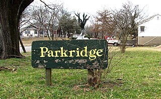
Parkridge is a neighborhood in Knoxville, Tennessee, United States, located off Magnolia Avenue east of the city's downtown area. Developed as a streetcar suburb for Knoxville's professional class in the 1890s, the neighborhood was incorporated as the separate city of Park City in 1907, and annexed by Knoxville in 1917. In the early 1900s, the neighborhood provided housing for workers at the nearby Standard Knitting Mill factory.
The Dundee City Hall and Fire Station was located at 4921 Underwood Avenue in the present-day Dundee neighborhood of Omaha, Nebraska.

Chilhowee Park is a residential neighborhood in Knoxville, Tennessee, United States, located off Magnolia Avenue in the East Knoxville area. Developed as a streetcar suburb in the 1890s, this neighborhood was initially part of Park City, which was incorporated as a separate city in 1907, and annexed by Knoxville in 1917. Chilhowee Park lies adjacent to one of Knoxville's largest municipal parks, as well as Zoo Knoxville. The neighborhood contains a notable number of early-20th-century houses.

