Field Club (Omaha, Nebraska)

Last updated
Field Club Historic District
Omaha, Nebraska Woolworth Ave x 36 St NE corner.JPG
Northeast corner of 36th Street and Woolworth Avenue
USA Nebraska location map.svg
Red pog.svg
Usa edcp location map.svg
Red pog.svg
Location Omaha, Nebraska
Coordinates 41°14′43″N95°57′50″W / 41.24528°N 95.96389°W / 41.24528; -95.96389 Coordinates: 41°14′43″N95°57′50″W / 41.24528°N 95.96389°W / 41.24528; -95.96389
ArchitectJohn McDonald, et al.
Architectural styleLate Victorian, Late 19th And 20th Century Revivals
NRHP reference No. 00001380 [1]
Added to NRHPNovember 15, 2000

Field Club is a neighborhood located in the Midtown region of Omaha, Nebraska. Roughly bounded by Pacific Street, 32nd Avenue, Center St., and 36th Street, the neighborhood was placed on the National Register of Historic Places as a historic district on November 15, 2000. [2] Field Club is the location of dozens of historically significant homes in the Omaha area, including the Gerald R. Ford Birthsite and Gardens.

Contents

History

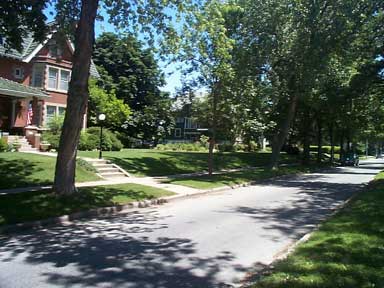
In its earlier years, Field Club was a late 19th-century suburb located at the southwest boundaries of Omaha. It was connected to the city center by the new trolley system which made it a convenient place to live for the well-to-do of the time. It was a highly desirable area, as it was plotted between two developed green sites. The first of these green areas, east of the neighborhood, was Hanscom Park, Omaha's first city park, which was founded in 1872. Hanscom Park was named for early Omaha attorney Andrew Jackson Hanscom, influential in the battle to secure Omaha as the territorial capital. He was a major donor of land that became that park. The second site, located on the west, was the Omaha Field Club. Founded in 1898, it was Omaha's first country club and golf course, and is the namesake of the neighborhood.

By the turn of the 20th century, many of Omaha's most noteworthy citizens had houses designed and built in the district by many prominent architects of the time. These houses have been well preserved over the last hundred-plus years. In the late 1990s, a local historian named Edward J. Quinn began the research to get the neighborhood listed on the National Register of Historic Places with the support of the Field Club Homeowners League and the Nebraska State Historical Society. The Field Club Historic District was listed in 2000. For his work, in 2001 Mayor Fahey appointed Quinn to sit on the City of Omaha Landmarks Heritage Preservation Commission, and in 2007 Quinn was honored for his efforts by the Douglas County Historical Society.

The Omaha Quartermaster Depot Historic District lies just east of the neighborhood.

See also

Related Research Articles

Dundee–Happy Hollow Historic District United States historic place

The Dundee–Happy Hollow Historic District is located west of Midtown Omaha, Nebraska. It covers the area between Harney Street on the south, Hamilton Street on the north, Happy Hollow Boulevard on the west, and 46th Street on the east. The "heart" of Dundee is located at 50th and Underwood Avenue in Omaha, Nebraska, United States. It was founded in 1880 and annexed into the city in 1915. Dundee is home to Warren Buffett and nationally syndicated editorial cartoonist Jeff Koterba and was the hometown of filmmaker Alexander Payne. Actor Henry Fonda additionally lived in the Dundee neighborhood.

North Omaha, Nebraska

North Omaha is a community area in Omaha, Nebraska, in the United States. It is bordered by Cuming and Dodge Streets on the south, Interstate 680 on the north, North 72nd Street on the west and the Missouri River and Carter Lake, Iowa on the east, as defined by the University of Nebraska at Omaha and the Omaha Chamber of Commerce.

The history of North Omaha, Nebraska includes wildcat banks, ethnic enclaves, race riots and social change spanning over 200 years. With a recorded history that pre-dates the rest of the city, North Omaha has roots back to 1812 with the founding of Fort Lisa. It includes the Mormon settlement of Cutler's Park and Winter Quarters in 1846, a lynching before the turn-of-the-twentieth-century, the thriving 24th Street community of the 1920s, the bustling development of the African-American community through the 1950s, a series of riots in the 1960s, and redevelopment in the late 20th and early 21st century.

Fort Omaha United States historic place

Fort Omaha, originally known as Sherman Barracks and then Omaha Barracks, is an Indian War-era United States Army supply installation. Located at 5730 North 30th Street, with the entrance at North 30th and Fort Streets in modern-day North Omaha, Nebraska, the facility is primarily occupied by Metropolitan Community College. A Navy Operational Support Center and Marine Corps Reserve unit, along with an Army Reserve unit occupy the periphery of the 82.5 acres (33.4 ha) fort. The government deeded all but four parcels of the land to the community college in 1974.

History of Omaha, Nebraska

The history of Omaha, Nebraska, began before the settlement of the city, with speculators from neighboring Council Bluffs, Iowa staking land across the Missouri River illegally as early as the 1840s. When it was legal to claim land in Indian Country, William D. Brown was operating the Lone Tree Ferry to bring settlers from Council Bluffs to Omaha. A treaty with the Omaha Tribe allowed the creation of the Nebraska Territory, and Omaha City was founded on July 4, 1854. With early settlement came claim jumpers and squatters, and the formation of a vigilante law group called the Omaha Claim Club, which was one of many claim clubs across the Midwest. During this period many of the city's founding fathers received lots in Scriptown, which was made possible by the actions of the Omaha Claim Club. The club's violent actions led to the U.S. Supreme Court trial, Baker v. Morton, which led to the end of the organization.

The neighborhoods of Omaha are a diverse collection of community areas and specific enclaves. They are spread throughout the Omaha metro area, and are all on the Nebraska side of the Missouri River.

Midtown Omaha Municipal area

Midtown is a geographic area of Omaha, Nebraska that is a culturally, socially and economically important area of the city. It is home to major research centers, national corporations, several historic districts, and a number of historic residences.

Country Club Historic District (Omaha, Nebraska) United States historic place

The Country Club Historic District is located in Omaha, Nebraska from 50th to 56th Streets, from Corby to Seward Streets. With dozens of homes built between 1925 and 1949 in the late 19th and 20th Century Revival styles, the community was added to the National Register of Historic Places in 2004.

Gold Coast Historic District (Omaha, Nebraska) United States historic place

The Gold Coast Historic District is located in Midtown Omaha, Nebraska. Listed on the National Register of Historic Places in 1997, this historic district covers approximately a 30 block area roughly bounded by 36th, 40th, Jones, and Cuming Streets. The neighborhood housed many of Omaha's cultural and financial leaders between 1900 and 1920, taking over from Omaha's original Gold Coast in prominence.

Morton Meadows is a historic neighborhood located in Midtown Omaha, Nebraska. The neighborhood lies between Center and Leavenworth Streets, from 42nd Street to Saddle Creek, and is sometimes referred to by its central boulevard, Twin Ridge. It is near the Dundee area, as well as the Gold Coast, Field Club and Country Club historic districts.

Bemis Park Landmark Heritage District Place in Bemis Park

The Bemis Park Landmark Heritage District is located in North Omaha, Nebraska. Situated from Cuming Street to Hawthorne Avenue, Glenwood Avenue to 33rd Street, Bemis Park was annexed into Omaha in 1887, and developed from 1889-1922. The district was designated an Omaha Landmark in 1983.

The Kountze Place neighborhood of Omaha, Nebraska is a historically significant community on the city's north end. Today the neighborhood is home to several buildings and homes listed on the National Register of Historic Places. It is located between North 16th Avenue on the east to North 30th Street on the west; Locust Street on the south to Pratt Street on the north. Kountze Place was annexed into Omaha in 1887. The neighborhood was built as a suburban middle and upper middle class enclave for doctors, lawyers, successful businessmen and other professional workers.

The Miller Park neighborhood in North Omaha, Nebraska is a historically significant community housing a historic district and several notable historic places. It is located between Sorenson Parkway on the south and Redick Avenue on the north, Florence Boulevard on the east and 30th Street on the west. The Minne Lusa neighborhood borders on the north, and the Saratoga neighborhood is on the south. Fort Omaha borders the neighborhood on the west. Miller Park is the namesake park in the neighborhood, as well as the Miller Park Elementary School. In 2017, the Miller Park/Minne Lusa area was ranked as having the 2nd highest rate of homicides and other violent crimes out of 81 Omaha neighborhoods.

Minne Lusa United States historic place

The Minne Lusa Residential Historic District is located in North Omaha, Nebraska. It is included on the National Register of Historic Places. According to the National Park Service, it is an "example of a substantial, affordable single-family residential development within the city limits that was platted, developed and constructed by a single firm between 1915 and 1941." The neighborhood is filled with bungalows, Craftsman, and other styles that were popular in the era. There are 540 properties in the neighborhood that contribute to the historic district, the other 167 do not. Minne Lusa Boulevard is a contributing structure.

Hanscom Park

Hanscom Park is a historic neighborhood in Midtown Omaha, Nebraska. Its namesake public park is one of the oldest parks in Omaha, donated to the City in 1872. U.S. President Gerald R. Ford was born in a house in the Hanscom Park neighborhood. Its boundaries are Center Street on the north, South 42nd on the west, Interstate 480 on the east and I-80 on the south.

Vinton Street Commercial Historic District United States historic place

The Vinton Street Commercial Historic District is located along Vinton Street between Elm Street on the west and South 17th Street on the east in south Omaha, Nebraska. This district is located adjacent to Sheelytown, a residential neighborhood that had historically significant populations of Irish, Poles, and Eastern European immigrants. It grew along with the success of the Union Stockyards and South Omaha. It was added to the National Register of Historic Places in 2006.

Sheelytown was a historic ethnic neighborhood in South Omaha, Nebraska, USA with populations of Irish, Polish and other first generation immigrants. Located north of the Union Stockyards, it was bounded by Edward Creighton Boulevard on the north, Vinton Street on the south, South 24th Street to the east, and 35th Street to the west. Sheelytown was named for the Sheely Brothers Packing Houses that were located in the area. Sheelytown was annexed by Omaha in 1887. The Omaha Quartermaster Depot was built just east of the community across the Union Pacific tracks.

Boulevards in Omaha, Nebraska United States historic place

Boulevards in Omaha are part of a park and boulevard system originally designed in 1889 by Horace Cleveland. There are more than one hundred miles (160 km) of boulevards throughout the city of Omaha, Nebraska today.

Saddle Creek Underpass United States historic place

The Saddle Creek Underpass is located in the Midtown area of Omaha, Nebraska. Designed to carry Saddle Creek Road under Dodge Street, the underpass was constructed in 1934 by the Works Progress Administration. It was included on the Bridges in Nebraska Multiple Property Submission on June 29, 1992.

Military Avenue (Omaha) United States historic place

Military Avenue is a central thoroughfare located in Omaha, Nebraska. A segment of the road located at the junction of West 82nd and Fort Streets was listed on the National Register of Historic Places in 1993. Today Military Road, which begins at Nebraska Highway 64 as Nebraska Highway L-28K, ends at Bennington Road near North 204th Street.

References

  1. "National Register Information System". National Register of Historic Places . National Park Service. January 23, 2007.
  2. (nd) National Register of Historic Places Listings November 24, 2000. National Park Service website. Retrieved 5/20/07.