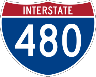
Interstate 480 (I-480) is a 4.9-mile-long (7.9 km) auxiliary Interstate Highway that connects I-80 in Downtown Omaha, Nebraska, with I-29 in Council Bluffs, Iowa. The portion of I-480 in Nebraska has been named the Gerald R. Ford Expressway, named in honor of the former president, who was a native of Omaha. For most of its length, I-480 is overlapped by a US Highway: for two miles (3.2 km) with US Highway 75 (US 75) and for one mile (1.6 km) with US 6. I-480 includes the Grenville Dodge Memorial Bridge over the Missouri River.

The Old Market is a neighborhood located in downtown Omaha, Nebraska, United States, and is bordered by South 10th Street to the east, 13th Street to the west, Farnam Street to the north and Jackson Street to the South. The neighborhood has many restaurants, art galleries and upscale shopping. The area retains its brick paved streets from the turn of the 20th century, horse-drawn carriages, and covered sidewalks in some areas. It is not uncommon to see a variety of street performers, artists, and other vendors.
East Omaha is a geographically designated community located in Omaha, Nebraska. Located three miles (5 km) from downtown Omaha, East Omaha is the site of Eppley Airfield, Omaha's main airport, and Carter Lake. This area was Omaha's first annexation, joining the city in 1854. Originally separated from Omaha by the Missouri River, a large section of the area's land was dissected by a ruling from the U.S. Supreme Court in 1892. Today, 2,500 houses, a school, grocery stores and a church that made up the original town have been demolished and replaced by several government facilities, the Eppley Airfield, and more.
The history of Omaha, Nebraska, began before the settlement of the city, with speculators from neighboring Council Bluffs, Iowa staking land across the Missouri River illegally as early as the 1840s. When it was legal to claim land in Indian Country, William D. Brown was operating the Lone Tree Ferry to bring settlers from Council Bluffs to Omaha. A treaty with the Omaha Tribe allowed the creation of the Nebraska Territory, and Omaha City was founded on July 4, 1854. With early settlement came claim jumpers and squatters, and the formation of a vigilante law group called the Omaha Claim Club, which was one of many claim clubs across the Midwest. During this period many of the city's founding fathers received lots in Scriptown, which was made possible by the actions of the Omaha Claim Club. The club's violent actions were challenged successfully in a case ultimately decided by the U.S. Supreme Court, Baker v. Morton, which led to the end of the organization.
Architecture in Omaha, Nebraska, represents a range of cultural influences and social changes occurring from the late 19th century to present.

The South Omaha Main Street Historic District is located along South 24th Street between M and O Streets in South Omaha, Nebraska. It was added to the National Register of Historic Places in 1989. Home to dozens of historically important buildings, including the Packer's National Bank Building, the historic district included 129 acres (0.52 km2) and more than 32 buildings when listed.
Morton Meadows is a historic neighborhood located in Midtown Omaha, Nebraska. The neighborhood lies between Center and Leavenworth Streets, from 42nd Street to Saddle Creek, and is sometimes referred to by its central boulevard, Twin Ridge. It is near the Dundee area, as well as the Gold Coast, Field Club and Country Club historic districts.

Little Bohemia, or Bohemian Town, is a historic neighborhood in Omaha, Nebraska. Starting in the 1880s, Czech immigrants settled in this highly concentrated area, also called "Praha" (Prague) or "Bohemian Town", bounded by South 10th Street on the east, South 16th Street on the west, Pierce Street on the north, and Martha Street on the south, with a commercial area went along South 13th and South 14th Streets, centered on William Street. It was located south of downtown, and directly west of Little Italy. A portion of the neighborhood along South 13th Street was listed on the National Register of Historic Places in 2020.

Jobbers Canyon Historic District was a large industrial and warehouse area comprising 24 buildings located in downtown Omaha, Nebraska, US. It was roughly bound by Farnam Street on the north, South Eighth Street on the east, Jackson Street on the south, and South Tenth Street on the west. In 1989, all 24 buildings in Jobbers Canyon were demolished, representing the largest National Register historic district loss to date.

The Vinton Street Commercial Historic District is located along Vinton Street between Elm Street on the west and South 17th Street on the east in south Omaha, Nebraska. This district is located adjacent to Sheelytown, a residential neighborhood that had historically significant populations of Irish, Poles, and Eastern European immigrants. It grew along with the success of the Union Stockyards and South Omaha. It was added to the National Register of Historic Places in 2006.
Sheelytown was a historic ethnic neighborhood in South Omaha, Nebraska, USA with populations of Irish, Polish and other first generation immigrants. Located north of the Union Stockyards, it was bounded by Edward Creighton Boulevard on the north, Vinton Street on the south, South 24th Street to the east, and 35th Street to the west. Sheelytown was named for the Sheely Brothers Packing Houses that were located in the area. Sheelytown was annexed by Omaha in 1887. The Omaha Quartermaster Depot was built just east of the community across the Union Pacific tracks.

Downtown Omaha is the central business, government and social core of the Omaha–Council Bluffs metropolitan area, U.S. state of Nebraska. The boundaries are Omaha's 20th Street on the west to the Missouri River on the east and the centerline of Leavenworth Street on the south to the centerline of Chicago Street on the north, also including the CHI Health Center Omaha. Downtown sits on the Missouri River, with commanding views from the tallest skyscrapers.
Germans in Omaha immigrated to the city in Nebraska from its earliest days of founding in 1854, in the years after the Revolutions of 1848 in the German states. They continued to immigrate to Omaha in large numbers later in the 19th century, when many came from Bavaria and southern Germany, and into the early 20th century. Germans created and maintained a high cultural, social and political profile locally and nationally through the 1930s. In 1890, Germans comprised 23% of Omaha's population. By 1910, 57.4% of Omaha's total population of more than 124,000 identified as being of German descent.

Vinton School was built as a fourteen-room elementary school in 1908 at 2120 Deer Park Boulevard in the Deer Park neighborhood of Omaha, Nebraska, United States. Designed by Omaha architect Frederick W. Clarke, Vinton School is the earliest and most elaborate example of a Tudor Revival-style school in Omaha. Designated an Omaha Landmark in June 1990, the building was listed on the National Register of Historic Places in November 1989.

Packer's National Bank Building is located at 4939 South 24th Street in the South Omaha Main Street Historic District in south Omaha, Nebraska. It was built in 1907. In 1984, it was designated an Omaha Landmark and, in 1985, it was listed on the National Register of Historic Places.
The Carver Savings and Loan Association opened in 1944 as the first African-American financial institution in Omaha, Nebraska. Located at 2416 Lake Street next to the historic North 24th Street corridor, it was in the heart of the Near North Omaha neighborhood, and Omaha's African-American business district.
Rocheford & Gould were brick manufacturers and construction contractors in early Omaha, Nebraska. The firm built numerous brick structures during Omaha's transition from the wooden buildings of Nebraska's territorial days to more permanent structures. The buildings the firm built included breweries, schools, packing houses, business blocks, Vaudeville theaters, street car barns and power houses, and civic buildings. Many of the structures the firm built have been demolished but a few of their earliest structures still exist and are listed on the National Register of Historic Places.

The Arthur G. Rocheford Building is a historic commercial building at 1717 Vinton Street in South Omaha, Nebraska, United States. The building was built in 1913 to house Arthur G. Rocheford's Globe Plumbing Company. Rocheford served as the general contractor during construction of the building. The building was added to the National Register of Historic Places in 2006 as part of the admission of the Vinton Street Commercial Historic District.
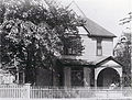
Blake & Zander was a leading firm of American architects, based in Omaha, Nebraska, active in the 19th century, albeit a short-lived practice.
Vinton Street Park was one of the most common names for the professional baseball park in Omaha, Nebraska from 1900 through 1936. It was destroyed by fire, and eleven years passed before Omaha acquired a professional ball club again.