Clifton is both a suburb of Bristol, England, and the name of one of the city's thirty-five council wards. The Clifton ward also includes the areas of Cliftonwood and Hotwells. The eastern part of the suburb lies within the ward of Clifton Down.

Bristol City Centre is the commercial, cultural and business centre of Bristol, England. It is the area north of the New Cut of the River Avon, bounded by Clifton Wood and Clifton to the north-west, Kingsdown and Cotham to the north, and St Pauls, Lawrence Hill and St Phillip's Marsh to the east. The Bristol Royal Infirmary, Bristol Royal Hospital for Children, the BBC, the main campus of the University of Bristol, the Crown and Magistrate's Courts, Temple Meads railway station, Bristol bus station, the Park Street, Broadmead and Cabot Circus shopping areas together with numerous music venues, theatres and restaurants are located in this area. The area consists of the council wards of Central, Hotwells & Harbourside, and part of Lawrence Hill.

Redland is a neighbourhood in Bristol, England. The neighbourhood is situated between Clifton, Cotham, Bishopston and Westbury Park. The boundaries of the district are not precisely defined, but are generally taken to be Whiteladies Road in the west, the Severn Beach railway line in the south and Cranbrook Road in the east.

Bristol, the largest city in South West England, has an eclectic combination of architectural styles, ranging from the medieval to 20th century brutalism and beyond. During the mid-19th century, Bristol Byzantine, an architectural style unique to the city, was developed, and several examples have survived.

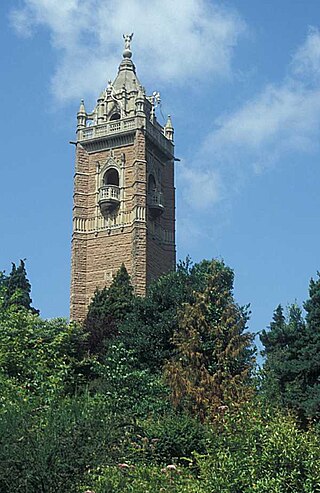
Cabot Tower is a tower in Bristol, England, situated in a public park on Brandon Hill, between the city centre, Clifton and Hotwells. It is a grade II listed building.

Cabot was a council ward that covered the centre of Bristol, England. It took its name from the Cabot Tower, a memorial tower on Brandon Hill that was built to commemorate John Cabot's voyage and "discovery" of North America. The ward was abolished in 2016.

The English city of Bristol has a number of parks and public open spaces.
The city of Bristol, England, is divided into many areas, which often overlap or have non-fixed borders. These include Parliamentary constituencies, council wards and unofficial neighbourhoods. There are no civil parishes in Bristol.

Bower Ashton is a village in south west Bristol on the western boundary with North Somerset, lying within the Southville ward, approximately two miles from the city centre. Ashton Court estate, a 850-acre (3.4 km2) recreational area owned by Bristol City Council lies just to the north, the Long Ashton by-pass to the south and the River Avon to the east.

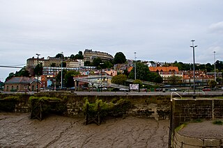
Hotwells is a district of the English port city of Bristol. It is located to the south of and below the high ground of Clifton, and directly to the north of the Floating Harbour. The southern entrance to the Avon Gorge, which connects the docks to the sea, lies at the western end of Hotwells. The eastern end of the area is at the roundabout where Jacobs Well Road meets Hotwell Road. Hotwells is split between the city wards of Clifton, and Hotwells and Harbourside.

College Green is a public open space in Bristol, England. The Green takes the form of a segment of a circle with its apex pointing east, and covers 1.1 hectares. The road named College Green forms the north-eastern boundary of the Green, Bristol Cathedral marks the south side, and City Hall closes the Green in an arc to the north-west.

Park Street is a major shopping street in Bristol, England, linking the city centre to Clifton. It forms part of the A4018.

Portland Square is a Grade I listed square in the St Paul's area of Bristol.
There are 212 Grade II* listed buildings in Bristol, England.

Berkeley Square is an area close to Park Street in the Clifton area of Bristol that includes buildings and a central area of greenery.

Royal York Crescent is a major residential street in Clifton, Bristol. It overlooks much of the docks, and much of the city can be seen from it. It also joins Clifton Village at one end. It is one of the most expensive streets in the city.

Cornwallis Crescent is a late 18th-century crescent of 24 Georgian town houses, located between York Gardens and Cornwallis Avenue in the Clifton area of Bristol. The postcode is within the Hotwells and Harbourside ward and electoral division, which is in the constituency of Bristol West.

Hotwells and Harbourside is one of the thirty-four council wards in the city of Bristol in the Southwest of England, United Kingdom.


