Berkeley Crescent, Bristol

Last updated

Berkeley Crescent
BerkeleyCBris.png
Berkeley Crescent Bristol
Bristol UK location map.svg
Red pog.svg
Location in Bristol
General information
Location Bristol, England
Coordinates 51°27′21″N2°36′32″W / 51.455898°N 2.6088854°W / 51.455898; -2.6088854
Design and construction
Architect(s)Paty

Berkeley Crescent is a late 18th-century crescent of six Georgian houses with a private communal garden.

Contents

History

It was designed by Thomas Paty (1713–1789) in 1787 and completed in c. 1800, possibly by his son, William Paty (1758–1800). [1] It was originally intended to be part of Berkeley Square. In the 14th century, the site was known as Bartholomew Close. [2]

Numbers 1–6 cover the south and east side of the crescent. The site is designated by the National Heritage List for England: Listed Building Grade II*. The houses are in the mid-Georgian style, constructed in brick with limestone dressings and a slate mansard roof. Each three-storey house has an attic and basement which has a double-depth plan. [3] [4] There is a raised flagged pavement with steps at each end. [5]

Location

The Crescent is located within the Park Street & Brandon Hill conservation area [6] between Berkeley Square and the Triangle in the Clifton area of Bristol. The postcode is within the Hotwells and Harbourside ward and electoral division, which is in the constituency of Bristol West. [7] Quarter runs serviced apartments, called Berkeley Suites at 6 Berkeley Crescent. The old Lyndale Hotel was situated at the end of the terrace at 19 Berkeley Square. [8] [9]

The Bristol Museum and Art Gallery, Cabot Tower in Brandon Hill Park, and the Wills Memorial Building of the University of Bristol is close by. [10] The Crescent was formerly in the parish of St Augustine the Less and is now in the parish of St. Stephen with St. James and St. John the Baptist with St. Michael, Bristol and St. George Bristol. [11]

Further reading

Related Research Articles

<span class="mw-page-title-main">Clifton, Bristol</span> Suburb of Bristol, England

Clifton is both a suburb of Bristol, England, and the name of one of the city's thirty-five council wards. The Clifton ward also includes the areas of Cliftonwood and Hotwells. The eastern part of the suburb lies within the ward of Clifton Down.

<span class="mw-page-title-main">Bristol city centre</span> Central Business District in England

Bristol City Centre is the commercial, cultural and business centre of Bristol, England. It is the area north of the New Cut of the River Avon, bounded by Clifton Wood and Clifton to the north-west, Kingsdown and Cotham to the north, and St Pauls, Lawrence Hill and St Phillip's Marsh to the east. The Bristol Royal Infirmary, Bristol Royal Hospital for Children, the BBC, the main campus of the University of Bristol, the Crown and Magistrate's Courts, Temple Meads railway station, Bristol bus station, the Park Street, Broadmead and Cabot Circus shopping areas together with numerous music venues, theatres and restaurants are located in this area. The area consists of the council wards of Central, Hotwells & Harbourside, and part of Lawrence Hill.

<span class="mw-page-title-main">Redland, Bristol</span> Human settlement in England

Redland is a neighbourhood in Bristol, England. The neighbourhood is situated between Clifton, Cotham, Bishopston and Westbury Park. The boundaries of the district are not precisely defined, but are generally taken to be Whiteladies Road in the west, the Severn Beach railway line in the south and Cranbrook Road in the east.

<span class="mw-page-title-main">Buildings and architecture of Bristol</span>

Bristol, the largest city in South West England, has an eclectic combination of architectural styles, ranging from the medieval to 20th century brutalism and beyond. During the mid-19th century, Bristol Byzantine, an architectural style unique to the city, was developed, and several examples have survived.

<span class="mw-page-title-main">Cabot Tower, Bristol</span> Tower in Bristol, England

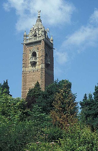
Cabot Tower is a tower in Bristol, England, situated in a public park on Brandon Hill, between the city centre, Clifton and Hotwells. It is a grade II listed building.

<span class="mw-page-title-main">Cabot, Bristol (former ward)</span> Human settlement in England

Cabot was a council ward that covered the centre of Bristol, England. It took its name from the Cabot Tower, a memorial tower on Brandon Hill that was built to commemorate John Cabot's voyage and "discovery" of North America. The ward was abolished in 2016.

<span class="mw-page-title-main">Parks of Bristol</span>

The English city of Bristol has a number of parks and public open spaces.

The city of Bristol, England, is divided into many areas, which often overlap or have non-fixed borders. These include Parliamentary constituencies, council wards and unofficial neighbourhoods. There are no civil parishes in Bristol.

<span class="mw-page-title-main">Bower Ashton</span> Human settlement in England

Bower Ashton is a village in south west Bristol on the western boundary with North Somerset, lying within the Southville ward, approximately two miles from the city centre. Ashton Court estate, a 850-acre (3.4 km2) recreational area owned by Bristol City Council lies just to the north, the Long Ashton by-pass to the south and the River Avon to the east.

<span class="mw-page-title-main">Hotwells</span> Human settlement in England

Hotwells is a district of the English port city of Bristol. It is located to the south of and below the high ground of Clifton, and directly to the north of the Floating Harbour. The southern entrance to the Avon Gorge, which connects the docks to the sea, lies at the western end of Hotwells. The eastern end of the area is at the roundabout where Jacobs Well Road meets Hotwell Road. Hotwells is split between the city wards of Clifton, and Hotwells and Harbourside.

<span class="mw-page-title-main">College Green, Bristol</span>

College Green is a public open space in Bristol, England. The Green takes the form of a segment of a circle with its apex pointing east, and covers 1.1 hectares. The road named College Green forms the north-eastern boundary of the Green, Bristol Cathedral marks the south side, and City Hall closes the Green in an arc to the north-west.

<span class="mw-page-title-main">Park Street, Bristol</span>

Park Street is a major shopping street in Bristol, England, linking the city centre to Clifton. It forms part of the A4018.

<span class="mw-page-title-main">Portland Square, Bristol</span>

Portland Square is a Grade I listed square in the St Paul's area of Bristol.

There are 212 Grade II* listed buildings in Bristol, England.

<span class="mw-page-title-main">Berkeley Square, Bristol</span> Area in Bristol, England

Berkeley Square is an area close to Park Street in the Clifton area of Bristol that includes buildings and a central area of greenery.

<span class="mw-page-title-main">Royal York Crescent</span>

Royal York Crescent is a major residential street in Clifton, Bristol. It overlooks much of the docks, and much of the city can be seen from it. It also joins Clifton Village at one end. It is one of the most expensive streets in the city.

<span class="mw-page-title-main">Cornwallis Crescent, Bristol</span> Building in Bristol, England

Cornwallis Crescent is a late 18th-century crescent of 24 Georgian town houses, located between York Gardens and Cornwallis Avenue in the Clifton area of Bristol. The postcode is within the Hotwells and Harbourside ward and electoral division, which is in the constituency of Bristol West.

<span class="mw-page-title-main">Hotwells and Harbourside</span> Human settlement in England

Hotwells and Harbourside is one of the thirty-four council wards in the city of Bristol in the Southwest of England, United Kingdom.

References

  1. Goodge, Mark. "1 to 6 and Attached Railings 19 and Attached Railings, Hotwells & Harbourside, City of Bristol". www.britishlistedbuildings.co.uk. Retrieved 11 April 2017.
  2. Evans, John (1 January 1824). A Chronological Outline of the History of Bristol, and the Stranger's Guide Through Its Streets and Neighbourhood. Printed at the office of the late "Bristol observer" and pub. by the author.
  3. "Berkeley Crescent, Clifton, Bristol, Bristol, England – Record Id: 4202". parksandgardens. Retrieved 8 August 2016.
  4. "1–6 BERKELEY CRESCENT INCLUDING 19 BERKELEY SQUARE". Pastscape. Retrieved 8 August 2016.
  5. "Berkeley Crescent, Clifton, Bristol". www.parksandgardens.org. Archived from the original on 12 April 2017. Retrieved 11 April 2017.
  6. Bristol City Council (2011). "Conservation Area 10 Park Street and Brandon Hill Character Appraisal and Management Proposals". Bristol.gov.uk.
  7. "Area Information for Berkeley Crescent, Bristol, BS8 1HA". Streetcheck. Retrieved 8 August 2016.
  8. The Vaughan collection (1930). "Lyndale Hotel, Berkeley Square, Clifton, Bristol". archives.bristol.gov.uk. Retrieved 11 April 2017.
  9. "The Crescent – 5* hotel living in Bristol". Clifton Hotels. Retrieved 8 August 2016.
  10. "Berkeley Crescent location". Google Maps. Retrieved 8 August 2016.
  11. "Church of England parish map". arcgis.com. Retrieved 11 April 2017.