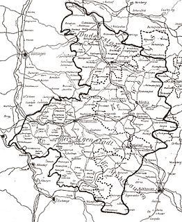
Göttingen is a district in Lower Saxony, Germany. It is bounded by the districts of Northeim and Goslar, and by the states of Thuringia and Hesse.
The Eichsfeld is a historical region in the southeast of the state of Lower Saxony and northwest of the state of Thuringia in the south of the Harz mountains in Germany. Until 1803 the Eichsfeld was for centuries part of the Archbishopric of Mainz, which is the cause of its current position as a Catholic enclave in the predominantly Protestant north of Germany. Following German partition in 1945, the West German portion became Landkreis Duderstadt. A few small transfers of territory between the American and Soviet zones of occupation took place in accordance with the Wanfried Agreement.

The Rigolets is a 12.9 kilometer (8 mi) long strait in Louisiana. "Rigolets" comes from the word rigole, French for "trench" or "gutter." The name is now locally pronounced "RIG-uh-leez." It begins at 30°10′40″N89°44′40″W and follows a generally eastward course to Lake Borgne, a lagoon in the Gulf of Mexico, and finally to the Gulf of Mexico, where it ends at 30°09′16″N89°37′31″W. Along with nearby Chef Menteur Pass, the Rigolets connects Lake Pontchartrain and Lake St. Catherine to Lake Borgne, and then to the Gulf of Mexico. It forms the boundary between New Orleans and St. Tammany Parish.
Vanaja is a former municipality of Finland. It was located in Tavastia Proper about 100 kilometres (60 mi) north of Helsinki. It is also speculated that it might have been the name for an Iron Age and early Middle Ages settlement found opposite to the Häme Castle.

Wysoka is a town in Piła County, Greater Poland Voivodeship, Poland, with 2,760 inhabitants (2004). The current Mayor is Marek Madej.

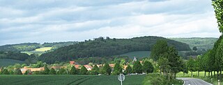
Benniehausen is a village in the Gemeinde Gleichen in southern Lower Saxony.
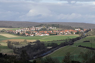
Klein Lengden is a village in the Gleichen in the Göttingen district of Lower Saxony, Germany, about eight to ten kilometers south-east of Göttingen. According to the 2010 census, it has about 1363 inhabitants. The village lies in the Garte valley, south of the forested hills of Lengderburg with its Lengdener Burg (castle) and Westerberg and is otherwise surrounded by farm fields. The nearest neighboring villages are Gross Lengden to the east and Diemarden to the west-south-west, each of which is about two kilometers distant.

Chałupki is a village in the administrative district of Gmina Sieradz, within Sieradz County, Łódź Voivodeship, in central Poland. It lies approximately 6 kilometres (4 mi) south-east of Sieradz and 52 km (32 mi) south-west of the regional capital Łódź.
Jasieniec Iłżecki Górny is a village in the administrative district of Gmina Iłża, within Radom County, Masovian Voivodeship, in east-central Poland. It lies approximately 8 kilometres (5 mi) south-west of Iłża, 32 km (20 mi) south of Radom, and 123 km (76 mi) south of Warsaw.
Góry Zborowskie is a village in the administrative district of Gmina Żelazków, within Kalisz County, Greater Poland Voivodeship, in west-central Poland. It lies approximately 12 kilometres (7 mi) north-east of Kalisz and 107 km (66 mi) south-east of the regional capital Poznań.
Łabędziewo is a settlement in the administrative district of Gmina Reszel, within Kętrzyn County, Warmian-Masurian Voivodeship, in northern Poland. It lies approximately 8 kilometres (5 mi) south of Reszel, 18 km (11 mi) south-west of Kętrzyn, and 50 km (31 mi) north-east of the regional capital Olsztyn.
Platyny is a village in the administrative district of Gmina Olsztynek, within Olsztyn County, Warmian-Masurian Voivodeship, in northern Poland. It lies approximately 8 kilometres (5 mi) west of Olsztynek and 29 km (18 mi) south-west of the regional capital Olsztyn.
Kądzielno is a village in the administrative district of Gmina Kołobrzeg, within Kołobrzeg County, West Pomeranian Voivodeship, in north-western Poland. It lies approximately 5 kilometres (3 mi) east of Kołobrzeg and 110 km (68 mi) north-east of the regional capital Szczecin.
Ziemomyśl A is a village in the administrative district of Gmina Dolice, within Stargard County, West Pomeranian Voivodeship, in north-western Poland. It lies approximately 9 kilometres (6 mi) east of Dolice (Dölitz), 26 km (16 mi) south-east of Stargard, and 56 km (35 mi) south-east of the regional capital Szczecin (Stettin).
Roringen is a village in the borough of Göttingen, Germany. High on a hill, it is separated from the city proper some 51⁄2 km to the south-west by farmlands and part of the Göttingen Forest.
Harste is a village to the northwest of Göttingen, Lower Saxony, Germany, belonging to the Gemeinde Bovenden.

Halfmijl is a hamlet in the west of the municipality of Veldhoven in the province of North Brabant, the Netherlands. The hamlet is located two kilometers east of the village Vessem and consists of eight houses, most of which are farms.

District 9 is a southern city district of Düsseldorf, the state capital of North Rhine-Westphalia, Germany. The district covers an area of 36,59 square kilometres and has about 89,000 inhabitants.


