Berry Castle, Black Dog

Last updated

Coordinates: 50°52′00″N3°42′24″W / 50.8667°N 3.7066°W / 50.8667; -3.7066

Geographic coordinate system Coordinate system

A geographic coordinate system is a coordinate system that enables every location on Earth to be specified by a set of numbers, letters or symbols. The coordinates are often chosen such that one of the numbers represents a vertical position and two or three of the numbers represent a horizontal position; alternatively, a geographic position may be expressed in a combined three-dimensional Cartesian vector. A common choice of coordinates is latitude, longitude and elevation. To specify a location on a plane requires a map projection.

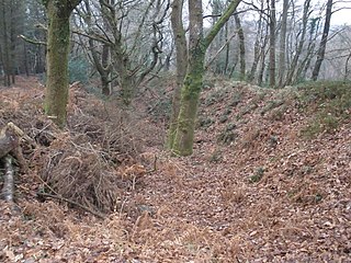
Berry Castle is an earthwork probably dating to the Iron Age close to Black Dog in Devon north of Crediton and west of Tiverton. It does not fit the traditional pattern of an Iron Age Hill fort. Although the earthwork would seem to be an incomplete enclosure, it is not at the top of a hill, although it is on the south east slope of a major hill which peaks at 199 Metres above Sea Level. [1]

The Iron Age is the final epoch of the three-age system, preceded by the Stone Age (Neolithic) and the Bronze Age. It is an archaeological era in the prehistory and protohistory of Europe and the Ancient Near East, and by analogy also used of other parts of the Old World. The three-age system was introduced in the first half of the 19th century for the archaeology of Europe in particular, and by the later 19th century expanded to the archaeology of the Ancient Near East. Its name harks back to the mythological "Ages of Man" of Hesiod. As an archaeological era it was first introduced for Scandinavia by Christian Jürgensen Thomsen in the 1830s. By the 1860s, it was embraced as a useful division of the "earliest history of mankind" in general and began to be applied in Assyriology. The development of the now-conventional periodization in the archaeology of the Ancient Near East was developed in the 1920s to 1930s. As its name suggests, Iron Age technology is characterized by the production of tools and weaponry by ferrous metallurgy (ironworking), more specifically from carbon steel.

Black Dog, Devon village in United Kingdom

Black Dog is a village in Mid Devon, ten miles west of Tiverton and six miles north of Crediton.

Devon County of England

Devon, also known as Devonshire, which was formerly its common and official name, is a county of England, reaching from the Bristol Channel in the north to the English Channel in the south. It is part of South West England, bounded by Cornwall to the west, Somerset to the north east, and Dorset to the east. The city of Exeter is the county town. The county includes the districts of East Devon, Mid Devon, North Devon, South Hams, Teignbridge, Torridge, and West Devon. Plymouth and Torbay are each geographically part of Devon, but are administered as unitary authorities. Combined as a ceremonial county, Devon's area is 6,707 km2 and its population is about 1.1 million.

Related Research Articles

Dumpdon Hill hillfort in Devon

Dumpdon Hill is an Iron Age Hill Fort near Honiton in Devon. Somewhat overshadowed by its better known neighbour Hembury Fort it is nonetheless as impressive an earthwork.

Clovelly Dykes is an Iron Age hill fort or earthwork near Clovelly, Devon, England. Situated on the high plateau behind the coast at approx 210 metres above sea level, it is one of the largest and most impressive Early Iron Age hill-forts in Devon. It is a complex series of earthworks covering more than 20 acres (8.1 ha).

Castle Close hillfort in Devon

Castle Close is a circular earthwork located near Stoodleigh in Mid Devon, England at OS grid reference SS937181. It is described on maps as a settlement. Situated some 208 metres above sea level, overlooking the River Exe, it is most likely to be an Iron Age Hill fort or enclosure.

Belbury Castle is the name given to an Iron Age earthwork, probably a hill fort or livestock enclosure, close to Ottery St Mary in Devon, England. The earthwork is on part of a hilltop at approximately 115 metres (377 ft) above sea level.

High Peak, Devon hill fort

High Peak is a hill which is partially eroded, resulting in a cliff face, on the English Channel coast to the southwest of Sidmouth, Devon, southern England. Its highest point is about 157 metres (515 ft) above sea-level. It is a partially eroded Iron Age hill fort, with pre-Roman and post Roman pottery found there.

Woodbury Castle Hillfort near Woodbury in Devon

Woodbury Castle is an Iron Age hillfort near the village of Woodbury in the English county of Devon, some eight miles southeast of the city of Exeter.

Prestonbury Castle hillfort in Devon

Prestonbury Castle is an Iron Age Hill fort on the north east edge of Dartmoor in Devon, England. Situated on a massive hilltop some 240 metres above sea level overlooking the Teign Valley, it is located near two other hill forts both of which lie about 2 km (1 mi) away.

Castle Hill, Torrington Iron Age earthworks and hill fort in Devon

There are two hills named Castle Hill within the immediate environs of Great Torrington in Devon, England. The first is within the town and is the site of the Norman & mediaeval castles, but was probably an Iron Age hill fort before this.50.9509°N 4.1436°W

Berry Camp

Berry Camp or Berry Cliff, is an Iron Age Hill fort on a partially eroded cliff top close to Branscombe in Devon. The cliff is situated some 140 metres (460 ft) above sea level.

Seaton Down is the location of an Iron Age hill fort in Devon, England, that takes the form of an earthwork with a large linear rampart cutting a promontory of land at the northeast end of the down off as a defensive fortification. It is slightly unusual in this layout when compared with other forts in the area. The fort is approximately 125 metres (410 ft) above sea level.

Musbury Castle hillfort in Devon

Musbury Castle is an Iron Age Hill fort situated above the Village of Musbury in Devon. The fort occupies a commanding hill top approx 175 Metres above Sea Level overlooking the Axe valleyat Ordnance Survey grid reference SY282941.

Wooston Castle hillfort in Devon

Wooston Castle is an Iron Age Hill fort situated on the edge of a hill overlooking the Teign Valley in Devon some 200 metres above sea level, only 3 km south and east of Prestonbury Castle and 5 km east of Cranbrook Castle.

Cranbrook Castle hillfort in Devon

Cranbrook Castle is an Iron Age Hill fort occupying a commanding hilltop just to the south of and overlooking the Teign valley in Devon. It is 337 metres above sea level and 2 km south and slightly west of Prestonbury castle, 3 km west of Wooston Castle.

Berry Castle may refer to the following places in England:

Berry Castle is an Iron Age Hill fort in the civil parish of Huntshaw, close to Weare Giffard in Devon, England, to the north of Great Torrington. The fort takes the form of an oval enclosure situated on a promontory in Huntshaw Wood some 95 Metres above Sea Level. Recent tree clearance (2015) has revealed that the 'fort' is rectangular in shape with entrances at either end, and may be a Roman camp or a local example of a neolithic sky burial enclosure.

Castle Head is a British Iron Age Hill fort occupying a commanding position on a promontory at the neck of a bow in the River Tamar on the Devon side close to Dunterton. The fort is situated approximately 100 metres above sea level, there is another earthwork due South lower on the promontory at approx 50 metres above sea level, and others on the Cornwall side of the river.

Berry's Wood is an Iron Age hill fort situated close to Newton Abbot in Devon, England. The fort is situated at about 75 metres above sea level on a commanding promontory above the River Lemon with views down the Teign Estuary. It lies on the hilltop above Bradley Manor.

Holne Chase Castle is an Iron Age hill fort situated close to Buckland-in-the-Moor in Devon, England. The fort is situated on a promontory on the Northern slopes of Holne Chase in Chase Wood at approx 150 Metres above Sea Level overlooking the River Dart.

Blackdown Rings

The Blackdown Rings are the earthworks of an Iron Age hill fort near the hamlet of Hazelwood in Devon, England. The fort is situated on a hilltop approximately 185 metres (607 ft) above sea level, in a commanding position above the River Avon.

Newberry Castle is an Iron Age Hill Fort close to Combe Martin in Devon, England.It takes the form of an earthwork hillside enclosure close on an outcrop of a hill on the north eastern shoulder of Newberry Hill at an elevation 110 Metres above Sea Level.

References

  1. R.R.Sellman; Aspects of Devon History, Devon Books 1985 - ISBN   0-86114-756-1 - Chapter 2; The Iron Age in Devon. Map Page 11 of Iron Age hill forts in Devon includes Berry Castle.