
Exmoor is loosely defined as an area of hilly open moorland in west Somerset and north Devon in South West England. It is named after the River Exe, the source of which is situated in the centre of the area, two miles north-west of Simonsbath. Exmoor is more precisely defined as the area of the former ancient royal hunting forest, also called Exmoor, which was officially surveyed 1815–1818 as 18,810 acres (7,610 ha) in extent. The moor has given its name to a National Park, which includes the Brendon Hills, the East Lyn Valley, the Vale of Porlock and 55 km (34 mi) of the Bristol Channel coast. The total area of the Exmoor National Park is 692.8 km2 (267.5 sq mi), of which 71% is in Somerset and 29% in Devon.

Dunster is a village, civil parish and former manor within the English county of Somerset, today just within the north-eastern boundary of the Exmoor National Park. It lies on the Bristol Channel coast 2.5 miles (4 km) south-southeast of Minehead and 20 miles (32 km) northwest of Taunton. The United Kingdom Census of 2011 recorded a parish population of 817.

Brompton Regis is a village and civil parish in the Somerset West and Taunton district of Somerset, England about 5 miles (8.0 km) north-east of Dulverton. It is situated on the River Pulham in the Brendon Hills within the Exmoor National Park, close to Wimbleball Lake, a water supply reservoir constructed in the 1970s and completed in 1979. According to the 2011 census the village had a population of 449. The parish boundary is marked by the River Exe which is crossed by the medieval Chilly Bridge and Hele Bridge. The Haddeo is crossed by Bury Bridge.

Christchurch Castle is located in Christchurch, Dorset, England. The earliest stonework has been dated to 1160. It is a Norman motte and bailey castle. The castle's site is inside the old Saxon burh dominating the River Avon's lowest crossing.
Ham Castle is located in Worcestershire at the bottom of a wooded escarpment, within the parish of Clifton-upon-Teme, about 1 mile (1.6 km) east of the village of Clifton-upon-Teme and 4 miles (6.4 km) south of Great Witley.
Watch Hill Castle is an early medieval motte-and-bailey on the border of Bowdon and Dunham Massey, England. It is a scheduled monument. As the only Scheduled Ancient Monument in Trafford, it is arguably the most important archaeological site in the borough. The castle is located north of the River Bollin and south of a deep ravine.

Pilsbury Castle was a Norman castle in Derbyshire near the present-day village of Pilsbury, overlooking the River Dove.
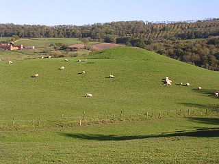
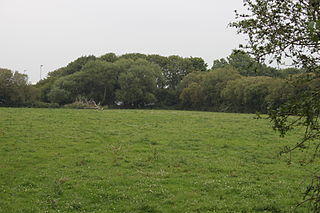
Bury Castle is an Iron Age hill fort near Selworthy, Somerset, England. It has been scheduled as an ancient monument.

The Gallox Bridge in Dunster, Somerset, England dates from the 15th century. It has been designated as a Grade I listed building and scheduled monument. The bridge is in the guardianship of English Heritage.
Parracombe is a rural settlement 4 miles (6 km) south-west of Lynton, in Devon, England. It is situated in the Heddon Valley, on Exmoor. The population at the 2011 census was 293.

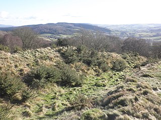
Mounsey Castle is an Iron Age irregular triangular earthwork of 1.75 hectares north west of Dulverton, Somerset, England. It has been scheduled as an ancient monument. It has been added to the Heritage at Risk Register.
Locking Castle was a castle that once stood on Carberry Hill near the site of RAF Locking in Locking in the North Somerset district of Somerset, England. It has been scheduled as an ancient monument.
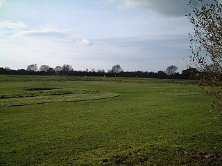
Down End Castle, also known as Downend Castle, Chisley Mount or Chidley Mount, was a motte-and-bailey castle at Down End, north of Dunball in the parish of Puriton, Somerset, England. It has been designated as a Scheduled Ancient Monument.

Sand Point in Somerset, England, is the peninsula stretching out from Middle Hope, an 84.1-hectare (208-acre) biological and geological Site of Special Scientific Interest. It lies to the north of the village of Kewstoke, and the stretch of coastline called Sand Bay north of the town of Weston-super-Mare. On a clear day it commands views over Flat Holm, of the Bristol Channel, South Wales, Clevedon, the Second Severn Crossing and the Severn Bridge. A line drawn between Sand Point and Lavernock Point in South Wales marks the lower limit of the Severn Estuary and the start of the Bristol Channel.

There are over 670 scheduled monuments in the ceremonial county of Somerset in South West England. The county consists of a non-metropolitan county, administered by Somerset County Council, which is divided into five districts, and two unitary authorities. The districts of Somerset are West Somerset, South Somerset, Taunton Deane, Mendip and Sedgemoor. The two administratively independent unitary authorities, which were established on 1 April 1996 following the breakup of the county of Avon, are North Somerset and Bath and North East Somerset. These unitary authorities include areas that were once part of Somerset before the creation of Avon in 1974.
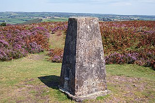
Haddon Hill is a prominent east–west aligned ridge in west Somerset, England, close to Hartford within the civil parish of Brompton Regis. It lies on the south-eastern fringe of Exmoor National Park though is separated from the Exmoor massif itself by the valleys of the rivers Haddeo and Exe The highest point of the ridge at OS grid reference SS 962286 is crowned by a trig point at 1,164 feet (355 m) above sea level. Much of the upper part of the hill is mapped as open access under the Countryside and Rights of Way Act 2000 and hence available for public access on foot. A couple of public footpaths traverse the hill north–south whilst numerous tracks run along its length. The larger part of the hill is within the national park, the boundary of which runs along the B3190 road which runs diagonally across the eastern end of the ridge en route from Watchet to Bampton. Vehicular access is available off this road. The hill affords views across Wimbleball Reservoir which occupies the Haddeo valley immediately to its north.

Bury Bridge at Bury in the parish of Brompton Regis within the English county of Somerset is a medieval packhorse bridge. It has been scheduled as an ancient monument and Grade II* listed building.

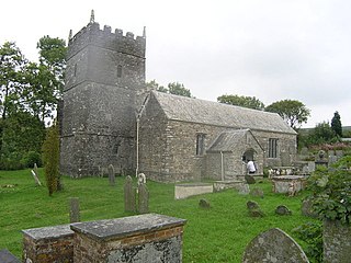
The Anglican Church of St Mary in Brompton Regis, Somerset, England was built in the 13th century. It is a Grade II* listed building.
West Somerset was a local government district in the English county of Somerset. It merged with Taunton Deane to form Somerset West and Taunton on 1 April 2019.

