
Berthoud Falls [1] is a populated place located south of Berthoud Pass on U.S. Highway 40 in north-central Colorado. The elevation is 9,800 feet.
Berthoud Falls [1] is a populated place located south of Berthoud Pass on U.S. Highway 40 in north-central Colorado. The elevation is 9,800 feet.

The historic Town of Empire is a Statutory Town located in Clear Creek County, Colorado, United States. The town population was 345 at the 2020 United States Census, a +22.34% increase since the 2010 United States Census. The town is a former mining settlement that flourished during the Colorado Silver Boom in the late 19th century. Empire is now a part of the Denver–Aurora–Lakewood, CO Metropolitan Statistical Area and the Front Range Urban Corridor.

Waterman is a village in DeKalb County, Illinois, United States. The population was 1,433 at the 2020 census.
Shiloh is a census-designated place (CDP) in Harrison Township in Montgomery County, Ohio, United States. It was delineated as a census-designated place at the 2000 census, at which time its population was 11,272. It was not delineated as a CDP at the 2010 census. It is located directly north of the city of Dayton and is part of the Dayton Metropolitan Statistical Area.
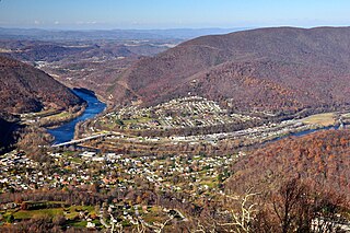
Narrows, named for the narrowing of the New River that flows through the town, is a town in Giles County, Virginia, United States. The population was 2,029 at the 2010 census, a decline of 3.9% from the 2000 count of 2,111. It is part of the Blacksburg–Christiansburg Metropolitan Statistical Area.

Middle Park is a high basin in the Rocky Mountains of north-central Colorado in the United States. It is located in Grand County, on the southwest slope of Rocky Mountain National Park, approximately 50 miles (80 km) west of Boulder.

Berthoud Pass is a high mountain pass in central Colorado, in the Front Range of the Rocky Mountains of the western United States.

The North Central Colorado Urban Area comprises the four contiguous metropolitan statistical areas in the north central region of the State of Colorado: the Denver–Aurora Metropolitan Statistical Area, the Boulder Metropolitan Statistical Area, the Fort Collins-Loveland Metropolitan Statistical Area, and the Greeley Metropolitan Statistical Area. With the exception of southeastern Elbert County, southeastern Park County, and tiny portions of southern Douglas County, the entire North Central Colorado Urban Area is drained by the South Platte River and its tributaries. The North Central Colorado Urban Area is the central, and the most populous, of the three primary subregions of the Front Range Urban Corridor.
West Berlin is an unincorporated community and census-designated place (CDP) located within Berlin Township in Camden County, in the U.S. state of New Jersey. The area is served as United States Postal Service ZIP Code 08091.

Bennettsville is an unincorporated community in Carr Township, Clark County, Indiana.
Mallow is an unincorporated community and census-designated place in Alleghany County, Virginia, United States. It was first listed as a CDP in the 2020 census with a population of 671.
Crutchfield Crossroads is an unincorporated community in northwestern Chatham County, North Carolina, United States, north of the town of Siler City. Crutchfield Crossroads is commonly defined as the area in and around the rural intersection of Silk Hope-Liberty Road. and Siler City- Snow Camp Road. At the intersection of the two roads, there are some stores, but other than that the entire community is agricultural. Children living in this area attend schools in Silk Hope and Siler City.

Cimarron is an unincorporated community in Harris County, Texas, United States. It lies 40 km west of the heart of Houston, and 6 km SE of Katy, at an elevation of 125 ft (38 m).

Havre Air Force Station is a Formerly Used Defense Site that was used as a Cold War general surveillance radar station. In addition to radar facilities and a NORAD Control Center the site had support services: NCO club, bowling alley, hobby shops, library, movie theater, barber shop, exchange, commissary, grade school, and housing for officers and senior NCOs.
Aubry is an unincorporated community in Johnson County, Kansas, United States, and part of the Kansas City metropolitan area.

Kharchakund is a mountain of the Garhwal Himalaya in Uttarakhand, India. The elevation of Kharchakund is 6,612 metres (21,693 ft) and its prominence is 835 metres (2,740 ft). It is 64th highest located entirely within the Uttrakhand. Nanda Devi, is the highest mountain in this category. It is surrounded by Gangotri Glacier and Ghanoim Bamak. Its nearest higher neighbor Kedarnath Dome 6,831 metres (22,411 ft) lies 6.4 km WNW. It is located 1.2 km NNE of Sumeru Parbat 6,351 metres (20,837 ft) and 10.7 km east lies Janhukut 6,829 metres (22,405 ft).
Kirti Stambh is a mountain of the Garhwal Himalaya in Uttarakhand India.The elevation of Kirti Stambh is 6,270 metres (20,571 ft) and its prominence is 100 metres (328 ft). It is 128th highest located entirely within the Uttrakhand. Nanda Devi, is the highest mountain in this category. It lies between Thalaysagar and Bhartekunta. Its nearest higher neighbor Bhartekunta 6,578 metres (21,581 ft) lies 2.3 km SE. It is located 5.1 km SSE of Thalaysagar 6,904 metres (22,651 ft) and 12.8 km NEE lies Bhagirathi I 6,856 metres (22,493 ft).

Bhartekunta is a mountain of the Garhwal Himalaya in Uttarakhand India.The elevation of Bhartekunta is 6,578 metres (21,581 ft) and its prominence is 280 metres (919 ft). It is 69th highest located entirely within the Uttrakhand. Nanda Devi, is the highest mountain in this category. It lies between Kirti Stambh and Kedarnath (mountain). Its nearest higher neighbor Kedarnath (mountain) 6,940 metres (22,769 ft) lies 3 km ESE. It is located 2.3 km SE of Kirti Stambh 6,279 metres (20,600 ft) and 6.9 km north lies Meru Peak 6,660 metres (21,850 ft).

Mandani Parbat is a mountain of the Garhwal Himalaya in Uttarakhand India.The elevation of Mandani Parbat is 6,193 metres (20,318 ft) and its prominence is 535 metres (1,755 ft). It is joint 140th highest located entirely within the Uttrakhand. Nanda Devi, is the highest mountain in this category. It lies between Chaukhamba IV, 6,854 metres (22,487 ft) and Sumeru Parbat, 6,351 metres (20,837 ft). Its nearest higher neighbor Chaukhamba IV lies 5.5 km east. It is located 8.4 km SE of Sumeru Parbat and 6.5 km NE lies Janhukut 6,829 metres (22,405 ft).

The San Luis Hills are a group of small mountain ranges in Conejos and Costilla counties in the San Luis Valley in southern Colorado. The individual mountain ranges that make up the San Luis Hills include the Fairy Hills, the Brownie Hills, the Piñon Hills, and the South Piñon Hills. The San Luis Hills' highest point is Flat Top, elevation 9,206 feet