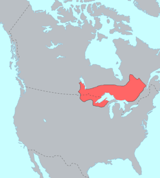
The Ojibwe are an Anishinaabe people whose homeland covers much of the Great Lakes region and the northern plains, extending into the subarctic and throughout the northeastern woodlands. Ojibweg, being Indigenous peoples of the Northeastern Woodlands and of the subarctic, are known by several names, including Ojibway or Chippewa. As a large ethnic group, several distinct nations also consider themselves Ojibwe, including the Saulteaux, Nipissings, and Oji-Cree.
Sandy Lake Band of Mississippi Chippewa are a historical Ojibwa tribe located in the upper Mississippi River basin, on and around Big Sandy Lake in what today is in Aitkin County, Minnesota. Though politically folded into the Mille Lacs Band of Ojibwe, thus no longer independently federally recognized, for decades, Sandy Lake Band members have been leading efforts to restore their independent Federal recognition.

The White Earth Band of the Minnesota Chippewa Tribe, also called the White Earth Nation, is a federally recognized Native American band in northwestern Minnesota. The band's land base is the White Earth Indian Reservation.

Fond du Lac Band of Lake Superior Chippewa is an Anishinaabe (Ojibwe) band located near Cloquet, Minnesota. Their land base is the Fond du Lac Indian Reservation, located mainly in Carlton and Saint Louis Counties, Minnesota, 20 miles west of Duluth.

The Mille Lacs Band of Ojibwe, also known as the Mille Lacs Band of Chippewa Indians, is a federally recognized American Indian tribe in east-central Minnesota. The Band has 4,302 members as of 2012. Its homeland is the Mille Lacs Indian Reservation, consisting of District I, District II, District IIa, and District III.
The Mille Lacs Indians, also known as the Mille Lacs and Snake River Band of Chippewa, are a Band of Indians formed from the unification of the Mille Lacs Band of Mississippi Chippewa (Ojibwe) with the Mille Lacs Band of Mdewakanton Sioux (Dakota). Today, their successor apparent Mille Lacs Band of Ojibwe consider themselves as being Ojibwe, but many on their main reservation have the ma'iingan (wolf) as their chief doodem (clan), which is an indicator of Dakota origins.
Mississippi River Band of Chippewa Indians or simply the Mississippi Chippewa, are a historical Ojibwa Band inhabiting the headwaters of the Mississippi River and its tributaries in present-day Minnesota.
The Treaty of Fond du Lac may refer to either of two treaties made and signed in Duluth, Minnesota between the United States and the Ojibwe (Chippewa) Native American peoples.

Chief Buffalo was a major Ojibwa leader, born at La Pointe in Lake Superior's Apostle Islands, in what is now northern Wisconsin, USA.

The Sandy Lake Tragedy was the culmination in 1850 of a series of events centered in Big Sandy Lake, Minnesota that resulted in the deaths of several hundred Lake Superior Chippewa. Officials of the Zachary Taylor Administration and Minnesota Territory sought to relocate several bands of the tribe to areas west of the Mississippi River. By changing the location for fall annuity payments, the officials intended the Chippewa to stay at the new site for the winter, hoping to lower their resistance to relocation. Due to delayed and inadequate payments of annuities and lack of promised supplies, about 400 Ojibwe, mostly men and 12% of the tribe, died of disease, starvation and cold. The outrage increased Ojibwe resistance to removal. The bands effectively gained widespread public support to achieve permanent reservations in their traditional territories.
The Lake Superior Chippewa are a large number of Ojibwe (Anishinaabe) bands living around Lake Superior; this territory is considered part of northern Michigan, Wisconsin, and Minnesota in the United States. They migrated into the area by the seventeenth century, encroaching on the Eastern Dakota people who had historically occupied the area. The Ojibwe defeated the Eastern Dakota, who migrated west into the Great Plains after the final battle in 1745. While they share a common culture including the Anishinaabe language, this highly decentralized group of Ojibwe includes at least twelve independent bands in the region.

Aysh-ke-bah-ke-ko-zhay was a powerful Ojibwe chief who traveled to Washington, D.C. in 1855, along with Beshekee and other Ojibwa leaders, to negotiate the cession of ten million acres (40,000 km2) including the headwaters of the Mississippi River in northern Minnesota. On 15 September 1862 the Chief meet Governor Ramsey at the Crow Wing Agency and offered to fight the Sioux along with a number of other Chiefs during the Santee Sioux Uprising.

Tamaha, also known as Standing Moose or "L'Orignal Levé," was one of two Mdewakanton Dakota scouts for the United States in the War of 1812, when most Sioux sided with the British. He was a member of Chief Red Wing's band and was presented with a medal and certificate by Governor William Clark of Missouri Territory for his loyalty to the U.S. The certificate was treasured by Tamaha, who called himself "the 'only' American Sioux," and can now be seen at the Minnesota History Center.

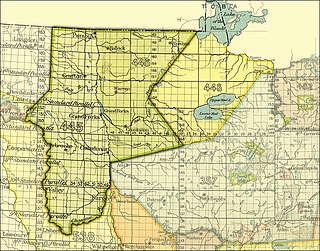
The Pembina and Red Lake bands of Chippewa ceded to the United States the Red River Valley of the north in two treaties. Both were named for the treaty site, "Old Crossing" and the year, Treaty of Old Crossing (1863) and the Treaty of Old Crossing (1864). In Minnesota, the ceded territory included all land west of a line running generally southwest from the Lake of the Woods to Thief Lake, about 30 miles (48 km) west of Red Lake, and then angling southeast to the headwaters of the Wild Rice River near the divide separating the watersheds of the Red River of the North and the Mississippi River. In North Dakota, the ceded territory was all of the Red River Valley north of the Sheyenne River. In size, the area was roughly 127 miles (204 km) east-west and 188 miles (303 km) north-south, making it nearly 11,000,000 acres (45,000 km2) of prairie and forest.
Sandy Lake is an unincorporated community Native American village located in Turner Township, Aitkin County, Minnesota, United States. Its name in the Ojibwe language is Gaa-mitaawangaagamaag, meaning "Place of the Sandy-shored Lake". The village is administrative center for the Sandy Lake Band of Mississippi Chippewa, though the administration of the Mille Lacs Indian Reservation, District II, is located in the nearby East Lake.

Wabasha II, also known as Wapahasha, Wapasha, or "The Leaf," succeeded his father as head chief of the Mdewakanton Dakota tribe in the early 1800s. He led the Dakota forces fighting with the British in the War of 1812, but sided with the United States in the Black Hawk War of 1832. Chief Wabasha II signed the Treaties of Prairie du Chien in 1825 and 1830.

Hole-in-the-Day was a prominent chief of the Mississippi band of Ojibwe/Chippewa in Minnesota. The native pronunciation has been written with different spellings due different speakers variance in their enunciation, such as Bagone-giizhig, Bagwunagijik, Bug-o-nay-ki-shig, Pugonakeshig or Puk-O-Nay-Keshig. Hole-in-the-Day has also been called Hole-in-the-Sky. The name refers to a dream in which the guardian spirit was seen through an opening in the clouds. It also refers to the Anishinaabek name for the constellation of the same name, also known as the Pleiades.

The Treaty of Prairie du Chien may refer to any of several treaties made and signed in Prairie du Chien, Wisconsin between the United States, representatives from the Sioux, Sac and Fox, Menominee, Iowa, Ho-Chunk and the Anishinaabeg Native American peoples.
Red Wing II, also known as Tatankamani was a leader of the Mdewakanton Dakota in the upper Mississippi Valley. During the War of 1812, Chief Red Wing II initially supported the British together with other Dakota chiefs, but switched sides to support the Americans in 1814. His village was at Barn Bluff in present-day Red Wing, Minnesota.

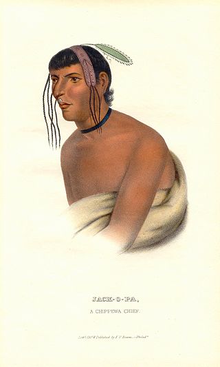
Zhaagobe (c.1794), also known as Jack-O-Pa or Shagobai, was a St. Croix Ojibwe chief of the Snake River band. He signed several Chippewa treaties with the United States, including the 1825 Treaty of Prairie du Chien, the 1826 Treaty of Fond du Lac, the 1837 Treaty of St. Peters, and the 1842 Treaty of La Pointe. In 1836, geographer Joseph Nicollet had an Ojibwe guide he called Chagobay, but historians are uncertain as to whether they were the same person.


