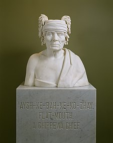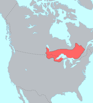
The Ojibwe are an Anishinaabe people whose homeland covers much of the Great Lakes region and the northern plains, extending into the subarctic and throughout the northeastern woodlands. Ojibweg, being Indigenous peoples of the Northeastern Woodlands and of the subarctic, are known by several names, including Ojibway or Chippewa. As a large ethnic group, several distinct nations also consider themselves Ojibwe, including the Saulteaux, Nipissings, and Oji-Cree.

Alexander Ramsey was an American politician, who became the first Minnesota Territorial Governor and later became a U.S. Senator. He served as a Whig and Republican over a variety of offices between the 1840s and the 1880s.

The White Earth Indian Reservation is home to the White Earth Band, in northwestern Minnesota. It is the largest Indian reservation in the state by land area. The reservation includes all of Mahnomen County, plus parts of Becker and Clearwater counties in the northwest part of the state along the Wild Rice and White Earth rivers. The reservation's land area is 1,093 square miles (2,830 km2). The population was 9,726 as of the 2020 census, including off-reservation trust land. The White Earth Indian Reservation is one of six bands that make up the Minnesota Chippewa Tribe, their governing body for major administrative needs. It is about 225 miles (362 km) from Minneapolis–Saint Paul and roughly 65 miles (105 km) from Fargo–Moorhead.
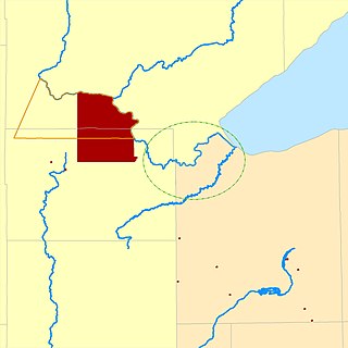
The Fond du Lac Indian Reservation is an Indian reservation in northern Minnesota near Cloquet in Carlton and Saint Louis counties. Off-reservation holdings are located across the state in Douglas County, in the northwest corner of Wisconsin. The total land area of these tribal lands is 154.49 square miles (400.1 km2). It is the land-base for the Fond du Lac Band of Lake Superior Chippewa. Before the establishment of this reservation, the Fond du Lac Band of Lake Superior Chippewa were located at the head of Lake Superior, closer to the mouth of the Saint Louis River, where Duluth has developed.

Fond du Lac Band of Lake Superior Chippewa is an Anishinaabe (Ojibwe) band located near Cloquet, Minnesota. Their land base is the Fond du Lac Indian Reservation, located mainly in Carlton and Saint Louis Counties, Minnesota, 20 miles west of Duluth.

The Mille Lacs Band of Ojibwe, also known as the Mille Lacs Band of Chippewa Indians, is a federally recognized American Indian tribe in east-central Minnesota. The Band has 4,302 members as of 2012. Its homeland is the Mille Lacs Indian Reservation, consisting of District I, District II, District IIa, and District III.
The Mille Lacs Indians, also known as the Mille Lacs and Snake River Band of Chippewa, are a Band of Indians formed from the unification of the Mille Lacs Band of Mississippi Chippewa (Ojibwe) with the Mille Lacs Band of Mdewakanton Sioux (Dakota). Today, their successor apparent Mille Lacs Band of Ojibwe consider themselves as being Ojibwe, but many on their main reservation have the ma'iingan (wolf) as their chief doodem (clan), which is an indicator of Dakota origins.
Mississippi River Band of Chippewa Indians or simply the Mississippi Chippewa, are a historical Ojibwa Band inhabiting the headwaters of the Mississippi River and its tributaries in present-day Minnesota.

John Okemos was a Ohioan Ojibwe (Chippewa) chief. He participated in Tecumseh's War and was a signatory of the Treaty of Saginaw. "Okemos" was the anglicised form of his Ojibwe language name ogimaans meaning "Little Chief". "John" was an adopted name.

Chief Buffalo was a major Ojibwa leader, born at La Pointe in Lake Superior's Apostle Islands, in what is now northern Wisconsin, USA.
The Battle of the Brule was an October 1842 battle between the La Pointe Band of Ojibwe Indians and a war party of Lakota Indians. The battle took place along the Brule River in what is today northern Wisconsin and resulted in a decisive victory for the Ojibwe.
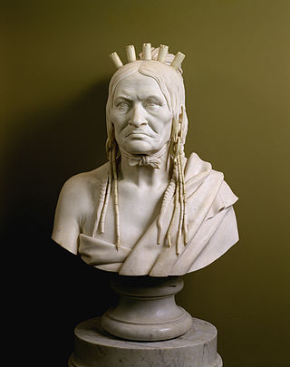
Beshekee, also Pezeke and other variant spellings of Ojibwe Bizhiki, was a noted war chief from the Bear doodem of the Pillager Chippewa Band during the 19th century in North America.
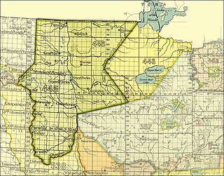
The Pembina and Red Lake bands of Chippewa ceded to the United States the Red River Valley of the north in two treaties. Both were named for the treaty site, "Old Crossing" and the year, Treaty of Old Crossing (1863) and the Treaty of Old Crossing (1864). In Minnesota, the ceded territory included all land west of a line running generally southwest from the Lake of the Woods to Thief Lake, about 30 miles (48 km) west of Red Lake, and then angling southeast to the headwaters of the Wild Rice River near the divide separating the watersheds of the Red River of the North and the Mississippi River. In North Dakota, the ceded territory was all of the Red River Valley north of the Sheyenne River. In size, the area was roughly 127 miles (204 km) east-west and 188 miles (303 km) north-south, making it nearly 11,000,000 acres (45,000 km2) of prairie and forest.
Treaty of St. Peters may be one of two treaties conducted between the United States and Native American peoples, conducted at the confluence of the Minnesota River with the Mississippi River, in what today is Mendota, Minnesota.
Shakopee or Chief Shakopee may refer to one of at least three Mdewakanton Dakota leaders who lived in the area that became Minnesota from the late 18th century through 1865. The name comes from the Dakota Śakpe meaning "Six." According to tribal histories, the very first "Shakpe" was called that because he was the sixth child of a set of sextuplets.

Hole-in-the-Day was a prominent chief of the Mississippi band of Ojibwe/Chippewa in Minnesota. The native pronunciation has been written with different spellings due different speakers variance in their enunciation, such as Bagone-giizhig, Bagwunagijik, Bug-o-nay-ki-shig, Pugonakeshig or Puk-O-Nay-Keshig. Hole-in-the-Day has also been called Hole-in-the-Sky. The name refers to a dream in which the guardian spirit was seen through an opening in the clouds. It also refers to the Anishinaabek name for the constellation of the same name, also known as the Pleiades.

The Treaty of Prairie du Chien may refer to any of several treaties made and signed in Prairie du Chien, Wisconsin between the United States, representatives from the Sioux, Sac and Fox, Menominee, Iowa, Ho-Chunk and the Anishinaabeg Native American peoples.
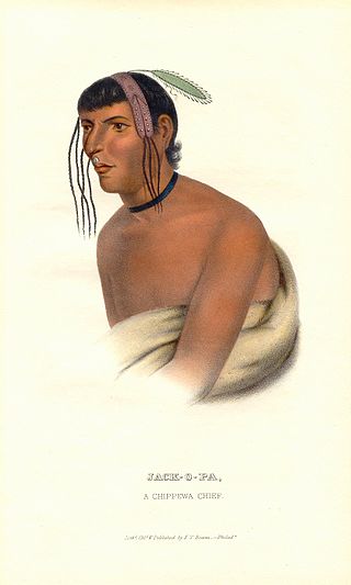
Zhaagobe (c.1794), also known as Jack-O-Pa or Shagobai, was a St. Croix Ojibwe chief of the Snake River band. He signed several Chippewa treaties with the United States, including the 1825 Treaty of Prairie du Chien, the 1826 Treaty of Fond du Lac, the 1837 Treaty of St. Peters, and the 1842 Treaty of La Pointe. In 1836, geographer Joseph Nicollet had an Ojibwe guide he called Chagobay, but historians are uncertain as to whether they were the same person.
