Bestumkilen

Last updated
Bestumkilen with the marina. In the background: Bygdoy. Bestumkilen 2013-07-17.jpg
Bestumkilen with the marina. In the background: Bygdøy.

Bestumkilen is a bay in Lysakerfjorden in the inner Oslofjord of Norway.

Lysakerfjorden is an arm of the Oslofjord in Norway. It starts at the mouth of the Lysaker River, and is bordered by the peninsulas Snarøya to the west and Bygdøy to the east.

Oslofjord fjord in southern Norway, with Oslo bordering the fjord

The Oslofjord is an inlet in the south-east of Norway, stretching from an imaginary line between the Torbjørnskjær and Færder lighthouses and down to Langesund in the south to Oslo in the north. It is part of the Skagerrak strait, connecting the North Sea and the Kattegat sea area, which leads to the Baltic Sea. The Oslofjord is not a fjord in the geological sense — in Norwegian the term fjord can refer to a wide range of waterways. The bay is divided into the inner and outer Oslofjord at the point of the 17 by 1 kilometre Drøbak Sound.

Located west of the Bygdøy peninsula and east of Vækerø, it is bordered by the islet Killingen in the southwest and the mouth of the river Hoffselva at Sjølyst in the northeast. It was formerly known, together with Frognerkilen, under the name Ladegaardsfjordene. [1] This stems from older times, when Bygdøy was an island, named Ladegaardsøen. Bygdøy later became a peninsula due to post-glacial rebound, separating Bestumkilen from Frognerkilen. [2] Propositions to reconnect Bestumkilen and Frognerkilen through a canal were made in 1928 and 1937, but not carried out. [3]

Bygdøy or Bygdø is a peninsula situated on the western side of Oslo, Norway. Administratively, Bygdøy belongs to the borough of Frogner. Bygdøy is also the home of five national museums as well as a royal estate.

Frognerkilen is a bay in the inner Oslofjord of Norway, east of the Bygdøy peninsula.

Post-glacial rebound Rise of land masses that were depressed by the huge weight of ice sheets during the last glacial period

Post-glacial rebound is the rise of land masses after the lifting of the huge weight of ice sheets during the last glacial period, which had caused isostatic depression. Post-glacial rebound and isostatic depression are phases of glacial isostasy, the deformation of the Earth's crust in response to changes in ice mass distribution. The direct raising effects of post-glacial rebound are readily apparent in parts of Northern Eurasia, Northern America, Patagonia, and Antarctica. However, through the processes of ocean siphoning and continental levering, the effects of post-glacial rebound on sea level are felt globally far from the locations of current and former ice sheets.

The rowing club Bestumkilen RK and the canoeing club Oslo KK are based in Bestumkilen. There is also a harbor for leisure boats.

Oslo KK

Oslo Kajakklubb is a sports club from Oslo, Norway.

Related Research Articles

Ullern District in Norway

Ullern is a district of the city of Oslo, Norway.

Bøler neighborhood in Oslo

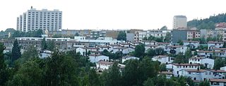
Bøler is a south-eastern suburb of Oslo, Norway. It is one of the more picturesque areas of Oslo. Østmarka forest and lake Nøklevann are in its immediately vicinity. Infrastructure-wise, it has a shopping center, two elementary schools, a public bath, a library, a church and a stop on the Østensjøbanen metro line.

Birkelunden

Birkelunden is a park placed centrally in the Grünerløkka borough of Oslo, Norway. It is formed as a rectangle, more or less like a city block.

Ormsund Roklub is a rowing club from Oslo, Norway.

Christiania RK Norwegian rowing club

Christiania Roklub is a rowing club from Oslo, Norway.

Linderud

Linderud is a neighborhood in Bjerke borough, Oslo, Norway. The area originally formed part of the estate of Linderud Manor.
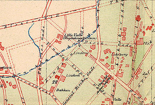
Lindern, Oslo

Lindern is an area in the borough St. Hanshaugen in Oslo, Norway.

Solli plass

Solli plass, pronounced /su:li/ or /suli/, /plas/ or /pɽas/, also called Lapsetorvet, is a square in Oslo, Norway, located southwest of Slottsparken and the Royal Palace.

Stortorvet

Stortorvet is a square in Oslo, Norway, located west of Oslo Cathedral.

Royal Norwegian Yacht Club

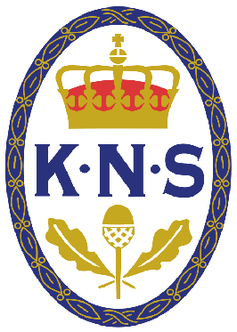
The Royal Norwegian Yacht Club is a yacht club in Oslo, Norway. The club was founded in 1883 as country-wide organisation with affiliated local yacht clubs. In 1884, it was granted the right for members to fly the naval Ensign of Norway with the Royal cypher on a centrally placed white field. In 1970, it was reorganized as local club for the Oslo area, under a new nationwide federation of yacht clubs. To date, the club has some 4,000 members.

Vigeland Museum museum dedicated to Gustav Vigelands art and life

The Vigeland Museum is a museum in Oslo, Norway.

Bredtvet neighborhood

Bredtvet is a neighborhood in the borough of Bjerke in Oslo, Norway.

Haugerud is a neighborhood in the borough of Alna in Oslo, Norway.

Keyserløkka

Keyserløkka is a neighborhood in the borough of Grünerløkka in Oslo, Norway.

Olaf Ryes plass

Olaf Ryes plass is a square and park placed centrally in the Grünerløkka borough of Oslo, Norway. It is more or less square in shape.

Schous plass square in Oslo, Norway

Schous plass is a square in the southern part of the borough of Grünerløkka in Oslo, Norway.

Elisenberg

Elisenberg is a neighborhood in the Frogner borough in Oslo, Norway.

Huk, Norway

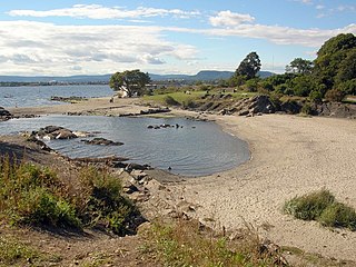
Huk is a parkland and a sandy beach (Hukodden) at the furthest south of the Bygdøy peninsula west of the city center of Oslo, Norway.

References

  1. Tvedt, Knut Are, ed. (2000). "Bestumkilen". Oslo byleksikon (4 ed.). Oslo: Kunnskapsforlaget. p. 61. ISBN   82-573-0815-3.
  2. Tvedt, Knut Are, ed. (2000). "Bygdøy". Oslo byleksikon (4 ed.). Oslo: Kunnskapsforlaget. p. 85. ISBN   82-573-0815-3.
  3. Tvedt, Knut Are, ed. (2000). "Frognerkilen". Oslo byleksikon (4 ed.). Oslo: Kunnskapsforlaget. p. 143. ISBN   82-573-0815-3.

Coordinates: 59°55′0″N10°40′1″E / 59.91667°N 10.66694°E / 59.91667; 10.66694

Geographic coordinate system Coordinate system

A geographic coordinate system is a coordinate system that enables every location on Earth to be specified by a set of numbers, letters or symbols. The coordinates are often chosen such that one of the numbers represents a vertical position and two or three of the numbers represent a horizontal position; alternatively, a geographic position may be expressed in a combined three-dimensional Cartesian vector. A common choice of coordinates is latitude, longitude and elevation. To specify a location on a plane requires a map projection.