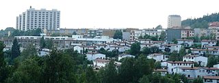
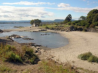
Frognerkilen is a bay in the inner Oslofjord of Norway, east of the Bygdøy peninsula.

The Oslofjord is an inlet in the south-east of Norway, stretching from an imaginary line between the Torbjørnskjær and Færder lighthouses and down to Langesund in the south to Oslo in the north. It is part of the Skagerrak strait, connecting the North Sea and the Kattegat sea area, which leads to the Baltic Sea. The Oslofjord is not a fjord in the geological sense — in Norwegian the term fjord can refer to a wide range of waterways. The bay is divided into the inner and outer Oslofjord at the point of the 17 by 1 kilometre Drøbak Sound.

Norway, officially the Kingdom of Norway, is a Nordic country in Northwestern Europe whose territory comprises the western and northernmost portion of the Scandinavian Peninsula; the remote island of Jan Mayen and the archipelago of Svalbard are also part of the Kingdom of Norway. The Antarctic Peter I Island and the sub-Antarctic Bouvet Island are dependent territories and thus not considered part of the kingdom. Norway also lays claim to a section of Antarctica known as Queen Maud Land.
Bygdøy or Bygdø is a peninsula situated on the western side of Oslo, Norway. Administratively, Bygdøy belongs to the borough of Frogner. Bygdøy is also the home of five national museums as well as a royal estate.
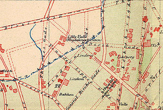
Its name stems from the neighbourhood Frogner, a name which was taken from a farm. [1] It was formerly known, with Bestumkilen, under the name of Ladegaardsfjordene. [2] This stems from older times, when Bygdøy was an island, named Ladegaardsøen. Bygdøy later became a peninsula due to post-glacial rebound, separating Bestumkilen from Frognerkilen. [3] Propositions to reconnect Bestumkilen and Frognerkilen through a canal were made in 1928 and 1937, but not carried out. It was an important shipping port for timber in the 17th and 18th centuries, but today a large part of the bay is used as a harbour for leisure boats. [4]

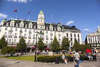
Frogner is a borough and an exclusive residential and retail district in the West End of the city of Oslo, Norway. In addition to traditional Frogner, the borough incorporates Bygdøy, Uranienborg and Majorstuen. The borough is named after Frogner Manor, and the famous Frogner Park is now found on the site of the manor. In Norwegian society, Frogner occupies a similar position as London's Knightsbridge, and has the highest real estate prices in the entire country. Most embassies are located in Frogner.

Bestumkilen is a bay in Lysakerfjorden in the inner Oslofjord of Norway.
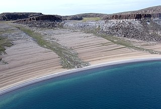
Post-glacial rebound is the rise of land masses after the lifting of the huge weight of ice sheets during the last glacial period, which had caused isostatic depression. Post-glacial rebound and isostatic depression are phases of glacial isostasy, the deformation of the Earth's crust in response to changes in ice mass distribution. The direct raising effects of post-glacial rebound are readily apparent in parts of Northern Eurasia, Northern America, Patagonia, and Antarctica. However, through the processes of ocean siphoning and continental levering, the effects of post-glacial rebound on sea level are felt globally far from the locations of current and former ice sheets.
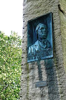
During the winter, Frognerkilen was used as a venue for harness racing —from 1875 to the 1920s—as well as speed skating in the pioneer days before 1900. [4] A skating competition between Axel Paulsen and Renke van der Zee from the Netherlands on Frognerkilen in 1885, when van der Zee challenged Paulsen for his title "amateur champion of the world", attracted approximately 30,000 spectators. [5] Kristiania Skøiteklub had Frognerkilen as its competition arena until Frogner stadion was opened in 1901.

Harness racing is a form of horse racing in which the horses race at a specific gait. They usually pull a two-wheeled cart called a sulky, occupied by a driver, although in Europe, jockeys riding directly on saddled trotters is also conducted.

Speed skating is a competitive form of ice skating in which the competitors race each other in travelling a certain distance on skates. Types of speed skating are long track speed skating, short track speed skating, and marathon speed skating. In the Olympic Games, long-track speed skating is usually referred to as just "speed skating", while short-track speed skating is known as "short track". The ISU, the governing body of both ice sports, refers to long track as "speed skating" and short track as "short track skating".
The speed skating race at Frognerkilen in 1885 was a duel between Norwegian skater Axel Paulsen and Dutch skater Renke van der Zee. The race took place on the fjord ice on the bay of Frognerkilen, Kristiania, on 26 February 1885. Paulsen had been named "amateur champion of the world" following a series of victories in the United States in 1883 and 1884, and he was challenged by Dutch skater van der Zee. The competition was met with huge interest from the local population. A crowd of between 20,000 and 30,000 spectators witnessed the duel. The newspaper Morgenbladet published a special edition on the event. The duel was fought over a length of 3 English miles. Paulsen won the race, finishing about one minute ahead of van der Zee. The prize money was 1,800 kr to the winner.
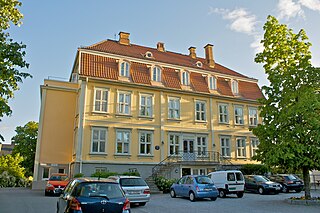
Frognerkilen was also a popular site of boat sports. The rowing club Christiania RK had its headquarters at the mainland, in a locality known as "Kongen" ('The King'), [6] whereas the Royal Norwegian Yacht Club had its headquarters at the opposite shore of Frognerkilen, in a locality known as "Dronningen" ('The Queen'). [7] Frognerkilen was formerly trafficked by ferry; one ferry sailed between the railway station at Skarpsno and Oscarshall at Bygdøy, and the other sailed between Skillebekk and Kongen. Also, Frognerkilen was probably the site where Fiskerlivets farer, depicting perils at sea, was filmed. Released in 1908, it is considered to be the Norwegian drama film. [4]
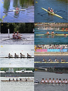
Rowing, often referred to as crew in the United States, is a sport whose origins reach back to Ancient Egyptian times. It involves propelling a boat on water using oars. By pushing against the water with an oar, a force is generated to move the boat. The sport can be either recreational for enjoyment or fitness, or competitive, when athletes race against each other in boats. There are a number of different boat classes in which athletes compete, ranging from an individual shell to an eight-person shell with a coxswain.

Christiania Roklub is a rowing club from Oslo, Norway.

The Royal Norwegian Yacht Club is a yacht club in Oslo, Norway. The club was founded in 1883 as country-wide organisation with affiliated local yacht clubs. In 1884, it was granted the right for members to fly the naval Ensign of Norway with the Royal cypher on a centrally placed white field. In 1970, it was reorganized as local club for the Oslo area, under a new nationwide federation of yacht clubs. To date, the club has some 4,000 members.