Related Research Articles

Eugene is a city in and the county seat of Lane County, Oregon, United States. It is located at the southern end of the Willamette Valley, near the confluence of the McKenzie and Willamette rivers, about 50 miles (80 km) east of the Oregon Coast.
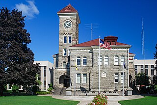
Polk County is one of the 36 counties in the U.S. state of Oregon. As of the 2020 census, the population was 87,433. The county seat is Dallas. The county is named for James Knox Polk, the 11th president of the United States.

Lane County is one of the 36 counties in the U.S. state of Oregon. As of the 2020 census, the population was 382,971, making it the fourth-most populous county in Oregon. The county seat is Eugene, the state's second most populous city. It is named in honor of Joseph Lane, Oregon's first territorial governor. Lane County comprises the Eugene, OR Metropolitan Statistical Area. It is the third-largest MSA in Oregon, and the 144th-largest in the country.
The Lane Transit District (LTD) is a public agency that provides public transportation in Lane County, Oregon, United States. The transit district serves the Eugene and Springfield metropolitan areas, including the neighboring cities of Coburg, Junction City, Creswell, Cottage Grove, Veneta, and Lowell. LTD began service in 1970 with 18 buses and two vans, and today carries roughly 10.5 million customers annually with a fleet of 111 buses. Many of LTD's riders are students; University of Oregon and Lane Community College students ride by simply showing their student I.D. Student fees subsidize both programs, as well as limited late-night service until about 1 a.m. In 2023, the system had a ridership of 6,266,700, or about 17,400 per weekday as of the third quarter of 2024.

Civic Stadium is an outdoor athletic stadium in the northwest United States, located in Eugene, Oregon. For most of its history it was owned by the Eugene School District. Opened in 1938, the stadium was destroyed by fire in 2015 on June 29.

Glenwood is an unincorporated community in Lane County, Oregon, United States. It is located between the University of Oregon in Eugene and downtown Springfield on Franklin Boulevard, along the former route of the Pacific Highway, now Oregon Route 99. It is a mixed-use industrial and residential area. The unincorporated character of the area has tended to attract "experimental and individualistic" inhabitants. For decades, Glenwood, which has been seen as a blighted area, has been the subject of redevelopment projects and proposals, including a riverfront redevelopment project.
Northgate is a neighborhood in Salem, Oregon, United States, located in the far north part of the city. It is one of Salem's larger districts and much of it is industrial rather than residential. Northgate has a neighborhood association, one of the nineteen such groups in Salem.

Ward Parkway is a boulevard in Kansas City, Missouri, United States. Ward Parkway begins at Brookside Boulevard on the eastern edge of the Country Club Plaza and travels west 2.8 miles along Brush Creek as U.S. Route 56 before turning south near Kansas-Missouri state line. It continues south for 4 miles, terminating at Wornall Road near Bannister Road. A short spur, Brush Creek Parkway, connects Ward Parkway to Shawnee Mission Parkway at State Line Road.

Willamette High School, or "Wil-Hi", is located in the Bethel-Danebo area of west Eugene, Oregon, United States. It is one of two high schools in the Bethel School District along with Kalapuya High School.

Bethel School District (52) is a school district in the U.S. state of Oregon. It serves the Bethel neighborhood in northwest Eugene. During the 2018–19 school year approximately 5,450 students were enrolled in Bethel's 11 schools, making it the third largest school district in Lane County.
Eugene School District (4J) is a public school district in the U.S. state of Oregon. It is one of two school districts that serve the city of Eugene.

Santa Clara is an unincorporated community in Lane County, Oregon and a neighborhood of Eugene. Prior to a number of partial annexations by the city between 1990 and 2005, Santa Clara was an unincorporated community and census-designated place in Lane County. Its current population is approximately 13,000.

Irving was an unincorporated community in Lane County, Oregon, United States, and now partly within the Eugene city limits.

Whiteaker is a neighborhood in Eugene, Oregon, United States. It is located to the northwest of downtown Eugene, and is home to primarily working class residents. Though it has served as an agricultural and commercial district in the past, it has become a primarily residential area. It is known as a vibrant cultural hub, center of community and environmental activism and home to alternative artists; it is increasingly also a nightlife district with many popular bars and restaurants.
Southeast is the southernmost neighborhood of Eugene, Oregon, United States. As defined by the City of Eugene, this neighborhood:

The West University Neighborhood (WUN) is a neighborhood in Eugene, Oregon, United States immediately west of the University of Oregon. The neighborhood encompasses the area west from Kincaid Street to Willamette Street, and north from East 19th Avenue to Franklin Boulevard. 97% of the residences in the neighborhood are renter-occupied. The area has been known in the past as a site of several student riots, most notably in 1998, 2001 and 2002, and has also seen several beautification and improvement efforts over the years.

The Eugene Public Library is a municipal public library in Eugene, Oregon, United States. It has been in four different buildings since 1898.
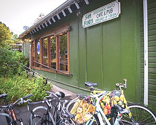
Sam Bonds Garage is a music venue and pub in the Whiteaker neighborhood of Eugene, Oregon, United States. It has been voted as one of America's best bars by Esquire.

Springfield is a city in Lane County, Oregon, United States. Located in the Southern Willamette Valley, it is within the Eugene-Springfield metropolitan statistical area. Separated from Eugene to the west, mainly by Interstate 5, Springfield is the second-most populous city in the metropolitan area after Eugene. As of the 2020 census, the city has a total population of 61,851, making it the ninth-most populous city in Oregon.
References
- ↑ "Neighborhood Associations: Active Bethel Citizens". City of Eugene. Retrieved September 8, 2011.
- ↑ "Neighborhood Map: City of Eugene Neighborhood Associations". City of Eugene. Retrieved September 8, 2011.