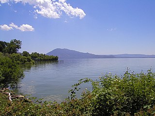
Lake County is a county located in the north central portion of the U.S. state of California. As of the 2010 census, the population was 64,665. The county seat is Lakeport. The county takes its name from Clear Lake, the dominant geographic feature in the county and the largest natural lake wholly within California.

Modoc County is a county in the far northeast corner of the U.S. state of California. As of the 2010 census, the population was 9,686, making it California's third-least populous county. The county seat and only incorporated city is Alturas. Previous county seats include Lake City and Centerville. The county borders Nevada and Oregon.

Siskiyou County is a county in the northernmost part of the U.S. state of California. As of the 2010 census, the population was 44,900. Its county seat is Yreka and its highest point is Mount Shasta.

Lane County is one of the 36 counties in the U.S. state of Oregon. As of the 2010 census, the population was 351,715, making it the fourth-most populous county in Oregon. The county seat is Eugene. It is named in honor of Joseph Lane, Oregon's first territorial governor.

Lake County is one of the 36 counties in the U.S. state of Oregon. As of the 2010 census, the population was 7,895. Its county seat is Lakeview. The county is named after the many lakes found within its boundaries, including Lake Abert, Summer Lake, Hart Lake, and Goose Lake.
Klamath County is one of the 36 counties in the U.S. state of Oregon. As of the 2010 census, the population was 66,380. The county seat is Klamath Falls. The county was named for the Klamath, the tribe of Native Americans living in the area at the time the first European explorers entered the region. Klamath County comprises the Klamath Falls, OR Micropolitan Statistical Area.

Colquitt County is a county in the U.S. state of Georgia. As of the 2010 census, the population was 45,498. The county seat is Moultrie. The county was created February 25, 1856 and is named for Walter Terry Colquitt, a U.S. senator. Colquitt County comprises the Moultrie, GA Micropolitan Statistical Area. It is the hometown of former U.S. Senator Saxby Chambliss. Colquitt County is the home of the Colquitt County Packers and is home to the 1994 Class AAAA and the 2014 and 2015 AAAAAA State Championship Football teams, along with the 1997 and 2003 State Champion Baseball teams.

Lakeview is a town in Lake County, Oregon, United States. The population was 2,294 at the 2010 census. It is the county seat of Lake County. The city bills itself as the "Tallest Town in Oregon" because of its elevation, 4,802 feet (1,464 m) above sea level. Lakeview is situated in the Goose Lake Valley at the foot of the Warner Mountains and at the edge of Oregon's high desert country. Its economy is based on agriculture, lumber production, and government activities. In addition, tourism is an increasingly important part of the city's economy. Oregon's Outback Scenic Byway passes through Lakeview.

Cottage Grove is a city in Lane County, Oregon, United States. The population was 9,686 at the 2010 census. Cottage Grove is the third largest city in Lane County. The city is located on Interstate 5, Oregon Route 99, and the main Willamette Valley line of the CORP railroad.
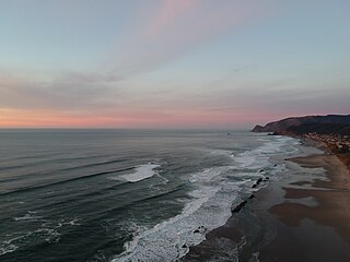
Lincoln City is a city in Lincoln County on the Oregon Coast between Tillamook and Newport. It is named after the county, which was named in honor of former U.S. President Abraham Lincoln. The population was 7,930 at the 2010 Census. During the solar eclipse of August 21, 2017, this city was the first in the path of totality to view a total solar eclipse.

Keizer is a city located in Marion County, Oregon, United States, along the 45th parallel. As of the 2010 United States Census, its population was 36,478. It lies in the Willamette Valley and is part of the Salem Metropolitan Statistical Area. It was named after pioneer Thomas Dove Keizur and his family who arrived in the Wagon Train of 1843, and later filed donation land claims.

Clear Lake Shores is a city in Galveston County, Texas, within the Houston–Sugar Land–Baytown metropolitan area. As of the 2010 census, the city population was 1,063.

El Lago is a city in Harris County, Texas, United States. The population was 2,706 at the 2010 census.

Fort Rock is a tuff ring located on an ice age lake bed in north Lake County, Oregon, United States. The ring is about 4,460 feet (1,360 m) in diameter and stands about 200 feet (60 m) high above the surrounding plain. Its name is derived from the tall, straight sides that resemble the palisades of a fort. The region of Fort Rock-Christmas Lake Valley Basin contains about 40 such tuff rings and maars and is located in the Brothers Fault Zone of central Oregon's Great Basin. William Sullivan, an early settler in the area, named Fort Rock in 1873 while searching for lost cattle.

Laurelwood is an unincorporated community in Washington County, Oregon, United States. The community is located southwest of the Portland metropolitan area near Oregon Route 47 along Laurelwood Road, to the east of the city of Gaston and Wapato Lake. Laurelwood, a farming community, has a population of approximately 500 people. Settled in the 1860s, the community was home to Laurelwood Academy from 1904 until 2007. A large portion of the community is of the Seventh-day Adventist faith.

Blachly is an unincorporated community in Lane County, Oregon, United States, on Oregon Route 36 in the Coast Range. Blachly lies along Lake Creek, about 3 miles (5 km) from Triangle Lake.
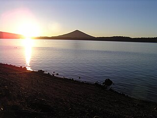
Crescent Lake is a natural lake on the eastern side of the Cascade Range in the northwest corner of Klamath County, Oregon, United States. The unincorporated community of Crescent Lake Junction on Oregon Route 58 and Crescent Lake State Airport are located 2.5 miles (4.0 km) northeast of the lake. The lake was named for its shape by Byron J. Pengra and William Holman Odell in July 1865.

Smith and Bybee Wetlands Natural Area is a public park and nature reserve between the Columbia Slough and the Columbia River in Portland, Oregon. At about 2,000 acres (810 ha), it is one of the largest urban freshwater wetlands in the United States. Metro, the regional government for the Oregon part of the Portland metropolitan area, manages the park. A covered shelter, restrooms, a paved walkway, and a canoe launch lie on the north side of the natural area.

Little Butte Creek is a 17-mile-long (27 km) tributary of the Rogue River in the U.S. state of Oregon. Its drainage basin consists of approximately 354 square miles (917 km2) of Jackson County and another 19 square miles (49 km2) of Klamath County. Its two forks, the North Fork and the South Fork, both begin high in the Cascade Range near Mount McLoughlin and Brown Mountain. They both flow generally west until they meet near Lake Creek. The main stem continues west, flowing through the communities of Brownsboro, Eagle Point, and White City, before finally emptying into the Rogue River about 3 miles (5 km) southwest of Eagle Point.

Oregon is a state in the Pacific Northwest region of the Western United States. The Columbia River delineates much of Oregon's northern boundary with Washington, while the Snake River delineates much of its eastern boundary with Idaho. The 42° north parallel delineates the southern boundary with California and Nevada.


