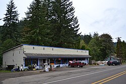
Swisshome, Oregon | |
---|---|
Coordinates: 44°3′29″N123°47′53″W / 44.05806°N 123.79806°W | |
Country | United States |
State | Oregon |
County | Lane |
Time zone | UTC-8 (Pacific (PST)) |
• Summer (DST) | UTC-7 (PDT) |
Swisshome is an unincorporated community in Lane County, in the U.S. state of Oregon. It is along the Siuslaw River northeast of Mapleton, on Oregon Route 36.
The community's name was conferred in honor of a local Swiss family. [1] Swisshome post office was established in 1902. [2] The Coos Bay Rail Link passes through Swisshome.
The Deadwood Creek Bridge and the Wildcat Creek Bridge near Swisshome are two covered bridges that are on the National Register of Historic Places. [3]
Lane County is one of the 36 counties in the U.S. state of Oregon. As of the 2020 census, the population was 382,971, making it the fourth-most populous county in Oregon. The county seat is Eugene, the state's second most populous city. It is named in honor of Joseph Lane, Oregon's first territorial governor.
The Bridal Veil Falls is a waterfall located on Bridal Veil Creek along the Columbia River Gorge in Multnomah County, Oregon, United States. The waterfall is accessible from the historic Columbia River Highway and Interstate 84. Spanning two tiers on basalt cliffs, it is the only waterfall which occurs below the historic Columbia Gorge Scenic Highway. The Bridal Veil Falls Bridge, built in 1914, crosses over the falls, and is listed on the National Register of Historic Places.
Oregon Route 36 is an Oregon state highway that runs between the city of Mapleton in the Oregon Coast Range, and the city of Junction City in the Willamette Valley. OR 36 traverses the Mapleton–Junction City Highway No. 229 of the Oregon state highway system. The entire route of the highway is located within Lane County.
Vida is an unincorporated community in Lane County, Oregon, United States. It is located on Oregon Route 126 and the McKenzie River.
Oregon Route 501 (OR 501) is an Oregon state highway running from the town of Alsea south 9.49 miles where it abruptly ends and turns into Lobster Valley Road at the intersection of Hazel Glen Road near the Benton-Lane County line. OR 501 is known as the Alsea-Deadwood Highway No. 201. It is 9.49 miles (15.27 km) long and runs north–south, entirely within Benton County.
Greenleaf is an unincorporated community in Lane County, Oregon, United States. Greenleaf lies on Oregon Route 36 east of Deadwood and west of Triangle Lake.
Walden is an unincorporated community in Lane County, Oregon, United States. It is about 3 miles (5 km) southeast of Cottage Grove, near the confluence of the Row River and Mosby Creek.
Wendling is an unincorporated community in Lane County, Oregon, United States, located northeast of Marcola. Wendling's post office operated from 1899 to 1952. The town was named for George X. Wendling, a San Francisco investor, who was the largest investor in Booth-Kelly's expansion into the Mohawk. Wendling was created as a company town for the Booth-Kelly Lumber Company.
Disston is an unincorporated community in Lane County, Oregon, United States, southeast of Cottage Grove where Brice Creek and Layng Creek join to form the Row River. It is about a mile west of the Umpqua National Forest. Its post office opened in 1906 and ran until 1974. Cranston Jones—the first postmaster—was also one of the founders of the first sawmill in Disston and the name of the town came from the famous Disston saws.
Wildcat Creek Bridge is a covered bridge built in 1925 at Austa, near Walton, in the U.S. state of Oregon. It uses Howe truss engineering and was listed on the National Register of Historic Places in 1979. The 75-foot (23 m) bridge carries Austa Road over Wildcat Creek near its confluence with the Siuslaw River.
Ten Mile Creek Bridge is a Conde McCullough-designed bridge near Yachats in Lane County in the U.S. state of Oregon. It was listed on the National Register of Historic Places in 2005.
The Pengra Bridge is a covered bridge near Jasper in the U.S. state of Oregon. The 120-foot (37 m) Howe truss structure carries Place Road over Fall Creek in Lane County. It replaced an earlier bridge, built in 1904, that crossed the creek a few feet further upstream.
The Deadwood Creek Bridge is a covered bridge in western Lane County in the U.S. state of Oregon. Built in 1932, the 105-foot (32 m) Howe truss structure carries Deadwood Loop Road over Deadwood Creek. The crossing lies upstream of the rural community of Deadwood in the Siuslaw National Forest of the Central Oregon Coast Range. The bridge was added to the National Register of Historic Places in 1979.
The Wendling Bridge is a covered bridge in Lane County in the U.S. state of Oregon. The 60-foot (18 m) Howe truss structure carries Wendling Road over Mill Creek in the unincorporated community of Wendling. Built in 1938, the bridge was added to the National Register of Historic Places in 1979.
Alpha is an unincorporated community in Lane County, in the U.S. state of Oregon.
Tenmile Creek is a stream in Lane County, in the U.S. state of Oregon. It flows west from the Siuslaw National Forest in the Oregon Coast Range into the Pacific Ocean at Stonefield Beach State Recreation Site, about 6 miles (10 km) south of Yachats.
The Horse Creek Bridge was a covered bridge near the unincorporated community of McKenzie Bridge in Lane County in the U.S. state of Oregon. Built in 1930, the structure, 105 feet (32 m) long, carried Horse Creek Road over Horse Creek. The creek is a tributary of the McKenzie River.
Deadwood Creek is a tributary of Lake Creek in the Siuslaw River basin in Lane County in the U.S. state of Oregon. Beginning near Taylor Butte in the Central Oregon Coast Range, it meanders generally southwest through the Siuslaw National Forest to meet the larger creek at the rural community of Deadwood. This is 5 miles (8 km) from Lake Creek's confluence with the river near Swisshome and 34 miles (55 km) by water from the Siuslaw River's mouth on the Pacific Ocean at Florence.
Lake Creek is a major tributary of the Siuslaw River in Lane County in the U.S. state of Oregon. On average, the 40-mile (64 km) long creek contributes about a third of the lower Siuslaw's water volume.