
Oxbow is an unincorporated community in Baker County, Oregon, United States. Oxbow is along Oregon Route 86 next to the Snake River near the Oxbow Dam on the Oregon-Idaho border, about 17 miles (27 km) northeast of Halfway. Oxbow is just south of the site of the former mining town of Copperfield. Oxbow has a post office with a ZIP code 97840.

Marcola is an unincorporated community in Lane County, Oregon, United States, northeast of Springfield on the Mohawk River.

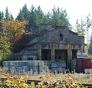
Copperfield is a former town in Baker County, in the U.S. state of Oregon. It is on the west bank of the Snake River and the north bank of Pine Creek, downstream of a feature of the Snake River known as The Oxbow. Copperfield Park, managed by Idaho Power, occupies the former town site. The Geographic Names Information System also lists Copperfield as a variant name for Oxbow, Oregon.
Norway is an unincorporated community in Coos County, Oregon, United States, located between Coquille and Myrtle Point on Oregon Route 42, near the Coquille River.
Cold Springs is an unincorporated community in Umatilla County, Oregon, United States, south of the Columbia River in the Hermiston area. Cold Springs Junction is a populated place and highway junction about 4 miles (6 km) northeast of Cold Springs at the junction of Oregon Route 37 and U.S. Route 730.
Sparta is an unincorporated community in Baker County, Oregon, United States. It was named for Sparta, Illinois, by William H. Packwood, a prominent Oregon pioneer who visited the gold diggings at the Powder River there in 1871.

Dolph is an unincorporated community in Tillamook County, Oregon, United States, near the Yamhill County line. It lies at the junction of Oregon Route 22 and Oregon Route 130 between Grande Ronde and Hebo, on the Little Nestucca River. It is within the Siuslaw National Forest in the Northern Oregon Coast Range.
Robinette is a former unincorporated community in Baker County, Oregon, United States.
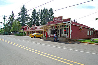
Macleay is an unincorporated community in Marion County, Oregon, United States, about nine miles east of downtown Salem in the Waldo Hills near the Little Pudding River.
Tonquin is an unincorporated locale in Washington County, Oregon, United States.
Walker is an unincorporated community in Lane County, Oregon, United States. It is located about 4 miles (6 km) north of Cottage Grove on Oregon Route 99, near the Coast Fork Willamette River.
Bridge is an unincorporated community in Coos County, Oregon, United States. It is about 9 miles (14 km) east of Myrtle Point on Oregon Route 42 near the Middle Fork Coquille River.
Brighton is an unincorporated community in Tillamook County, Oregon, United States. It is about 3 kilometres (2 mi) southwest of Wheeler on U.S. Route 101 next to Nehalem Bay, across the bay from Nehalem Bay State Park.

Gateway is an unincorporated community in Jefferson County, Oregon, United States. It is located about 16 miles east of Warm Springs.

Foss is an unincorporated community in Tillamook County, Oregon, United States. It is about 4 miles (6 km) east of Mohler and Oregon Route 53, near the Nehalem River. Foss is the site of an important river flood gauge.
Yarnell is an unincorporated historic locale in Lane County, Oregon, United States. It was located about 5 miles south of Mohawk, in the Mohawk Valley.
Suver is an unincorporated community in Polk County, Oregon, United States. It is located about 10 miles north of Corvallis and about 8 miles south of Monmouth, 1 mile east of Oregon Route 99W.
Blalock was an unincorporated community located in the Columbia River Gorge in Gilliam County, Oregon, United States. The town displaced a Native American settlement originally named Táwash. Blalock was located about 7 miles (11 km) west of Arlington on Interstate 84/U.S. Route 30 at the mouth of Blalock Canyon. Blalock is still the name of a station on the Union Pacific Railroad.
Rowland is a ghost town in Linn County, in the U.S. state of Oregon.
Tallman is a ghost town in Linn County, in the U.S. state of Oregon. It is located northwest of Lebanon.


