
Lane County is one of the 36 counties in the U.S. state of Oregon. As of the 2020 census, the population was 382,971, making it the fourth-most populous county in Oregon. The county seat is Eugene, the state's second most populous city. It is named in honor of Joseph Lane, Oregon's first territorial governor.

The Pudding River is a 62-mile (100 km) tributary of the Molalla River in the U.S. state of Oregon. Its drainage basin covers 528 square miles (1,368 km2). Among its tributaries are Silver Creek, Butte Creek, Abiqua Creek, and the Little Pudding River.

The Molalla River is a 51-mile (82 km) tributary of the Willamette River in the northwestern part of Oregon in the United States. Flowing northwest from the Cascade Range through Table Rock Wilderness, it passes the city of Molalla before entering the larger river near Canby. The Molalla is the largest Willamette tributary unblocked by a dam.

The Clackamas River is an approximately 83-mile (134 km) tributary of the Willamette River in northwestern Oregon, in the United States. Draining an area of about 940 square miles (2,435 km2), the Clackamas flows through mostly forested and rugged mountainous terrain in its upper reaches, and passes agricultural and urban areas in its lower third. The river rises in eastern Marion County, about 55 miles (89 km) east-southeast of Salem. The headwaters are on the slopes of Olallie Butte in the Mount Hood National Forest, about 10 miles (16 km) north of Mount Jefferson, at an elevation of 4,909 feet (1,496 m) in the Cascade Range. The Clackamas flows briefly north and then flows northwest through the mountains, passing through North Fork Reservoir and Estacada. It then emerges from the mountains southeast of Portland. It joins the Willamette near Oregon City and forms the boundary between Oregon City and Gladstone.
The Big River is a tributary of the Coast Fork Willamette River, approximately 12 miles (19 km) long, in western Oregon in the United States. It drains an area of the Calapooya Mountains south of Eugene.

The South Santiam River is a tributary of the Santiam River, about 69 miles (111 km) long, in western Oregon in the United States. It drains an area of the Cascade Range into the Willamette Valley east of Corvallis.

Mount Pisgah is a hill in Lane County, Oregon, United States, rising 1,060 feet (320 m) above the surrounding Willamette Valley to a maximum elevation of 1,531 feet (467 m). It was named after the biblical Mount Pisgah. It is situated between the Coast Fork and Middle Fork of the Willamette River, two miles (3 km) southeast of their confluence. Springfield is immediately north of Mount Pisgah, and the city of Eugene is a few miles west. It is the site of the 2363-acre Howard Buford Recreation Area as well as the non-profit Mount Pisgah Arboretum at its base.

Johnson Creek is a 25-mile (40 km) tributary of the Willamette River in the Portland metropolitan area of the U.S. state of Oregon. Part of the drainage basin of the Columbia River, its catchment consists of 54 square miles (140 km2) of mostly urban land occupied by about 180,000 people as of 2012. Passing through the cities of Gresham, Portland, and Milwaukie, the creek flows generally west from the foothills of the Cascade Range through sediments deposited by glacial floods on a substrate of basalt. Though polluted, it is free-flowing along its main stem and provides habitat for salmon and other migrating fish.
Tryon Creek is a 4.85-mile (7.81 km) tributary of the Willamette River in the U.S. state of Oregon. Part of the drainage basin of the Columbia River, its watershed covers about 6.5 square miles (16.8 km2) in Multnomah and Clackamas counties. The stream flows southeast from the Tualatin Mountains through the Multnomah Village neighborhood of Portland and the Tryon Creek State Natural Area to the Willamette in the city of Lake Oswego. Parks and open spaces cover about 21 percent of the watershed, while single-family homes dominate most of the remainder. The largest of the parks is the state natural area, which straddles the border between the two cities and counties.

Dorena is an unincorporated community in Lane County, Oregon, United States. It is located southeast of Cottage Grove on the Row River, a tributary of the Coast Fork Willamette River.

The Row River is a river, approximately 20 miles (32 km) long, in Lane County, Oregon, United States. It rises in the Cascade Range and flows into the Coast Fork Willamette River near Cottage Grove. The stream was originally known as the "East Fork Coast Fork", but was later renamed after a dispute between neighbors and brothers-in-law George Clark and Joseph Southwell over "trespassing" livestock. Clark was killed as a result of the row. The name rhymes with "cow" rather than with "slow". A post office named Row River operated from 1911 to 1914 a little north of the present site of Dorena at 43.740123°N 122.880347°W.

Salt Creek Falls is a cascade and plunge waterfall on Salt Creek, a tributary of the Middle Fork Willamette River, that plunges into a gaping canyon in the Willamette National Forest near Willamette Pass in Lane County, Oregon. The waterfall is notable for its main drop of 286 feet (87 m), ranking third highest among plunge waterfalls in Oregon, after Multnomah Falls and Watson Falls.) The pool at the bottom of Salt Creek Falls waterfall is 66 feet (20 m) deep.

McCredie Springs are hot springs and a former resort in Lane County, Oregon, United States. It is located near Oregon Route 58, 10.7 miles (17.2 km) east of Oakridge, and 50.7 miles (81.6 km) east of Eugene, within the Willamette National Forest. It is known for the nearby natural hot springs along Salt Creek.

The Willamette River is a 187-mile (301 km) tributary of the Columbia River in the U.S. state of Oregon. The upper tributaries of the Willamette originate in mountains south and southeast of the twin cities of Eugene and Springfield. Formed by the confluence of the Middle Fork Willamette River and Coast Fork Willamette River near Springfield, the main stem meanders generally north from source to mouth. The river's two most significant course deviations occur at Newberg, where the stream turns sharply east, and about 18 miles (29 km) downriver from Newberg, where it turns north again. Near its mouth, the river splits into two channels that flow around Sauvie Island. The main channel enters the Columbia about 101 miles (163 km) from the larger stream's mouth on the Pacific Ocean, and the smaller Multnomah Channel enters the Columbia about 14.5 miles (23.3 km) further downstream near St. Helens in Columbia County.

Hills Creek Dam is a dam about 4 miles (6.4 km) southeast of Oakridge in Lane County, Oregon, United States. It impounds Hills Creek Reservoir, which has a surface area of 2,735 acres (1,107 ha) and a shoreline of roughly 44 miles (71 km), on the Middle Fork Willamette River.

Mosby Creek is a 21-mile (34 km) tributary of the Row River in Lane County, in the U.S. state of Oregon. It begins at the confluence of the east and west forks of the creek near the Calapooia Divide and the border with Douglas County. From its source it flows generally north-northwest to meet the river slightly east of Cottage Grove and about 4 miles (6 km) from the larger stream's confluence with the Coast Fork Willamette River.

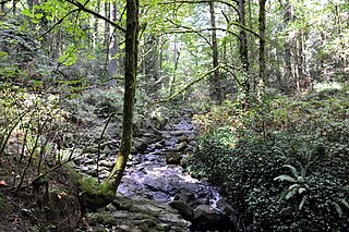
Fall Creek is a 34-mile (55 km) tributary of the Middle Fork Willamette River in Lane County in the U.S. state of Oregon. Beginning in the Cascade Range, the creek flows generally west through the Willamette National Forest to enter the Middle Fork upstream of Jasper, southeast of Springfield and Eugene.

Unity is an unincorporated community in Lane County in the U.S. state of Oregon. It lies long Fall Creek just below Fall Creek Reservoir, north of Lowell and southeast of Springfield and Eugene.

Fall Creek Lake is a reservoir in Lane County, in the U.S. state of Oregon. It is about 22 miles (35 km) southeast of Eugene on Fall Creek, immediately upstream from Unity Bridge, a covered bridge. The communities of Unity, at the bridge site, and Lowell, south of Unity, are near the lake. The unincorporated community of Jasper is further downstream, below the confluence of Fall Creek with the Middle Fork Willamette River.
Myrtle Creek is a short tributary of the South Umpqua River in Douglas County in the U.S. state of Oregon. Its main stem, formed by the confluence of two forks just south of the city of Myrtle Creek, is only about 1 mile (1.6 km) long. Its only named tributaries are the two forks, North Myrtle Creek and South Myrtle Creek, each of which is much longer than the main stem.

