Alvadore, Oregon

Last updated

Alvadore, Oregon
Alvadore, Oregon.jpg
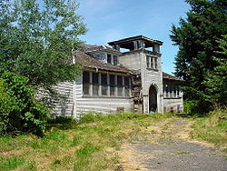
Alvadore's abandoned schoolhouse
USA Oregon location map.svg
Red pog.svg
Alvadore
Usa edcp location map.svg
Red pog.svg
Alvadore
Coordinates: 44°07′36″N123°15′52″W / 44.12667°N 123.26444°W / 44.12667; -123.26444
Country United States
State Oregon
County Lane
Elevation
[1]
384 ft (117 m)
Time zone UTC-8 (Pacific (PST))
  Summer (DST) UTC-7 (PDT)
ZIP codes
97409 (PO Boxes)
GNIS feature ID1136001 [1]

Alvadore is an unincorporated community in Lane County, Oregon, United States, located nine miles northwest of downtown Eugene and one mile northeast of Fern Ridge Reservoir.

Contents

History

Alvadore was named for Alvadore Welch of Portland, who built the Portland, Eugene and Eastern Railway through the community. [2] The railway was later acquired by the Southern Pacific Railroad, but in 1936 the track was torn up. [2] Alvadore post office was established in 1914. [2]

At one time Alvadore had a school. [3]

Climate

This region experiences warm (but not hot) and dry summers, with no average monthly temperatures above 71.6 °F (22.0 °C). According to the Köppen Climate Classification system, Alvadore has a warm-summer Mediterranean climate, abbreviated "Csb" on climate maps. [4]

Related Research Articles

<span class="mw-page-title-main">Oxbow, Oregon</span> Unincorporated community in the state of Oregon, United States

Oxbow is an unincorporated community in Baker County, Oregon, United States. Oxbow is along Oregon Route 86 next to the Snake River near the Oxbow Dam on the Oregon-Idaho border, about 17 miles (27 km) northeast of Halfway. Oxbow is just south of the site of the former mining town of Copperfield. Oxbow has a post office with a ZIP code 97840.

<span class="mw-page-title-main">Mapleton, Oregon</span> Unincorporated community in the state of Oregon, United States

Mapleton is an unincorporated community in Lane County, Oregon, United States. It is located on Oregon Route 126 and the Siuslaw River, 45 miles (72 km) west of Eugene and 15 miles (24 km) east of Florence. It is also the western terminus of Oregon Route 36. As of the 2000 census, Mapleton had a total population of 918.

<span class="mw-page-title-main">Noti, Oregon</span> Unincorporated community in the state of Oregon, United States

Noti is an unincorporated community in Lane County, Oregon, United States, located in the foothills of the Central Oregon Coast Range between Eugene and Florence. Per the 2000 census, Noti had a total population of 699.

Midland is an unincorporated community in Klamath County, Oregon, United States, about 8 miles (13 km) south of Klamath Falls on U.S. Route 97. The site was platted in 1908 and named Midland, with a post office established in 1909. At the time it was said the name was chosen because the town was halfway between Portland and San Francisco on the proposed Cascade Line of the Southern Pacific Railroad. It is not halfway, however, and it is now thought that the name refers to the town's site on land partly surrounded by marshes.

Beatty is an unincorporated community and census-designated place (CDP) in Klamath County, Oregon, United States. Beatty is along Oregon Route 140 at the confluence of the Sycan and Sprague rivers and is 40 miles (64 km) by highway northeast of Klamath Falls.

<span class="mw-page-title-main">Mount Hood, Oregon</span> Unincorporated community in the state of Oregon, United States

Mount Hood is an unincorporated community and census-designated place (CDP) in Hood River County, Oregon, United States, about 3 miles (5 km) northeast of Parkdale on Oregon Route 35. As of the 2010 census it had a population of 286. Mount Hood is the terminus of Oregon Route 281, the Hood River Highway.

Dairy is an unincorporated community in Klamath County, Oregon, United States.

<span class="mw-page-title-main">Eagle Creek, Oregon</span> Unincorporated community in the state of Oregon, United States

Eagle Creek is an unincorporated community in Clackamas County, Oregon, United States. It is located seven miles southwest of Sandy, seven miles north of Estacada, and five miles southeast of Carver, at the junction of Oregon Routes 224 and 211, on the Clackamas River.

<span class="mw-page-title-main">Imnaha, Oregon</span> Unincorporated community in the state of Oregon, United States

Imnaha is an unincorporated community at the confluence of Big Sheep Creek and the Imnaha River in Wallowa County, Oregon, United States. Its elevation is 1,978 feet (603 m). Oregon Route 350 connects Imnaha to the nearest incorporated city, Joseph, 30 miles (48 km) to the west. Imnaha is best known as the gateway to the Hat Point scenic lookout on Hells Canyon at the Snake River.

<span class="mw-page-title-main">Fort Klamath, Oregon</span> Unincorporated community in the state of Oregon, United States

Fort Klamath is an unincorporated community between Crater Lake National Park and Upper Klamath Lake in Klamath County, Oregon, United States.

<span class="mw-page-title-main">Days Creek, Oregon</span> Unincorporated community in the state of Oregon, United States

Days Creek is an unincorporated community and census-designated place in Douglas County, Oregon, United States. At the 2010 census it had a population of 272.

<span class="mw-page-title-main">Blue River, Oregon</span> Unincorporated community in the state of Oregon, United States

Blue River is an unincorporated community in Lane County, Oregon, United States. It is located on Oregon Route 126 along the McKenzie River, between the communities of Finn Rock and Rainbow. It is in the Willamette National Forest, where the Blue River empties into the McKenzie. The community was named after the Blue River, which was named for the striking blue color that apparently comes from its rocky bed. Five miles northeast of the community, a dam on the Blue River forms the Blue River Reservoir.

<span class="mw-page-title-main">Powell Butte, Oregon</span> Unincorporated community in the state of Oregon, United States

Powell Butte is an unincorporated community in Crook County, Oregon, United States, and named after the nearby Powell Buttes. It is on Oregon Route 126 west of Prineville and east of Redmond. Powell Butte post office was established in 1909.

<span class="mw-page-title-main">Dorena, Oregon</span> Unincorporated community in Oregon, United States

Dorena is an unincorporated community in Lane County, Oregon, United States. It is located southeast of Cottage Grove on the Row River, a tributary of the Coast Fork Willamette River.

<span class="mw-page-title-main">Walterville, Oregon</span> Unincorporated community in the state of Oregon, United States

Walterville is an unincorporated community in Lane County, Oregon, United States. It is located six miles (9.7 km) east of Springfield on Oregon Route 126 near the McKenzie River.

<span class="mw-page-title-main">Leaburg, Oregon</span> Unincorporated community in the state of Oregon, United States

Leaburg is an unincorporated community in Lane County, Oregon, United States located on the McKenzie River and Oregon Route 126 east of Walterville and west of Vida.

London Springs is an unincorporated community in Lane County, Oregon, United States. It lies 11.33 miles (18.23 km) south-southwest of Cottage Grove at an elevation of 896 feet (273 m). London Springs is near the Coast Fork Willamette River, south of Cottage Grove Lake.

<span class="mw-page-title-main">Curtin, Oregon</span> Unincorporated community in the state of Oregon, United States

Curtin is an unincorporated community in Douglas County, Oregon, United States. It is on Interstate 5 and the former Southern Pacific railroad line about 7 miles (11 km) northeast of Drain along Pass Creek. It stands at an elevation of 404 feet.

Broadbent is an unincorporated community in Coos County, Oregon, United States. Broadbent is on Oregon Route 542 south of Myrtle Point along the South Fork Coquille River. Broadbent has a post office with ZIP code 97414.

Walker is an unincorporated community in Lane County, Oregon, United States. It is located about 4 miles (6 km) north of Cottage Grove on Oregon Route 99, near the Coast Fork Willamette River.

References

  1. 1 2 U.S. Geological Survey Geographic Names Information System: Alvadore, Oregon
  2. 1 2 3 McArthur, Lewis A.; McArthur, Lewis L. (2003) [1928]. Oregon Geographic Names (7th ed.). Portland, Oregon: Oregon Historical Society Press. pp. 20–21. ISBN   978-0875952772.
  3. "Looking Back". The Register-Guard . June 21, 2001. Retrieved June 23, 2011.
  4. Climate Summary for Alvadore, Oregon