
Oxbow is an unincorporated community in Baker County, Oregon, United States. Oxbow is along Oregon Route 86 next to the Snake River near the Oxbow Dam on the Oregon-Idaho border, about 17 miles (27 km) northeast of Halfway. Oxbow is just south of the site of the former mining town of Copperfield. Oxbow has a post office with a ZIP code 97840.

Cascadia is an unincorporated community and census-designated place (CDP) that was established in 1892 on the South Santiam River, 14 miles (23 km) east of the current city of Sweet Home, in Linn County, Oregon, United States. As of the 2010 census it had a population of 147.

Eagle Creek is an unincorporated community in Clackamas County, Oregon, United States. It is located seven miles southwest of Sandy, seven miles north of Estacada, and five miles southeast of Carver, at the junction of Oregon Routes 224 and 211, on the Clackamas River.

Buxton is an unincorporated community in Washington County, Oregon, United States, near Oregon Route 47.

Powell Butte is an unincorporated community in Crook County, Oregon, United States, and named after the nearby Powell Buttes. It is on Oregon Route 126 west of Prineville and east of Redmond. Powell Butte post office was established in 1909.

Blodgett is a census-designated place (CDP) and unincorporated community in Benton County, Oregon, United States, where Oregon Route 180 meets U.S. Route 20 in the Central Oregon Coast Range 15 miles (24 km) west of Corvallis. It is near the confluence of the Tumtum and Marys rivers. As of the 2010 census, the community had a population of 58.

Timber is an unincorporated community in Washington County, Oregon, United States. Timber's population is 131, its ZIP code is 97144, it has 59 housing units and its land area is 17.45 sq mi (45.2 km2), with a population density of 7.51/sq mi (2.90/km2).

Post is an unincorporated community in Crook County, Oregon, United States. It has a post office assigned the ZIP code of 97752. Post lies along Oregon Route 380 southeast of Prineville at an elevation of 3,383 feet (1,031 m). Post was named for Walter H. Post, the first postmaster of the Post post office, established in 1889.
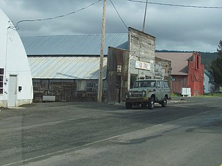
Mikkalo is an unincorporated community in Gilliam County, Oregon, United States, at an elevation of 1,470 feet (450 m). Mikkalo is about 4 miles (6.4 km) northwest of Clem. Mikkalo has a post office, serving ZIP code of 97861, and is in the 541 area code region. In 1905, the place was named for settler John Mikkalo, and a post office opened at Mikkalo in 1907. It was along the Condon Branch of the Union Pacific Railroad. The Mikkalo Farmers Elevator had a fire on March 28, 1921.
Bates is an unincorporated community in Grant County, Oregon, United States. it has a post office with a ZIP code 97817. The elevation is 4,062 feet (1,238 m).
Fox is an unincorporated community in Grant County, Oregon, United States, on U.S. Route 395 south of Long Creek.

Trail is a census-designated place and unincorporated community in Jackson County, Oregon, United States. As of the 2010 census it had a population of 702. It has a post office with a ZIP code of 97541.
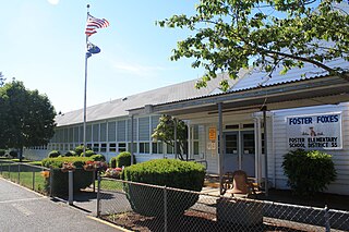
Foster is an unincorporated community partly within the city of Sweet Home in Linn County, Oregon. It is located on the western end of the Foster Reservoir. A post office named Foster serves ZIP code 97345, which serves areas beyond the Sweet Home city limits on both the north and south sides of Foster Lake: on the north side, the area extends along the Middle Santiam River to the west end of Green Peter Lake; on the south, the area extends for several miles along the South Santiam River and U.S. Route 20.

Curtin is an unincorporated community in Douglas County, Oregon, United States. It is on Interstate 5 and the former Southern Pacific railroad line about 7 miles (11 km) northeast of Drain along Pass Creek. It stands at an elevation of 404 feet.
Madeline is an unincorporated area in Lassen County, California. It is located 45 miles (72 km) north-northeast of Susanville, at an elevation of 5321 feet. Its population is 21 as of the 2020 census.
Dillard is an unincorporated community and census-designated place in Douglas County, Oregon, United States. Dillard is south of the city of Winston. Dillard has a post office with ZIP code 97432. As of the 2010 census, it had a population of 478.
Broadbent is an unincorporated community in Coos County, Oregon, United States. Broadbent is on Oregon Route 542 south of Myrtle Point along the South Fork Coquille River. Broadbent has a post office with ZIP code 97414.
Idleyld Park is an unincorporated community in Douglas County, Oregon, United States. Idleyld Park is located along Oregon Route 138 northeast of Glide. Idleyld Park has a post office with ZIP code 97447.
Crescent is an unincorporated community in Klamath County, Oregon, United States. Crescent is along U.S. Route 97 about 47 miles (76 km) south-southwest of Bend. Crescent has a post office with ZIP code 97733.
Chester is an unincorporated community in Fremont County, Idaho, United States. Chester is located on U.S. Route 20 6 miles (9.7 km) northeast of St. Anthony. Chester has a post office with ZIP code 83421.


