Related Research Articles

Oakridge is a city in Lane County, Oregon, United States. The population was 3,205 as of the 2010 census. It is located east of Westfir on Oregon Route 58, about 40 miles (64 km) east of Eugene and 150 miles (240 km) southeast of Portland. Surrounded by the Willamette National Forest and the Cascade Range, Oakridge is popular with outdoor enthusiasts for its hiking, mountain biking, wildflowers, fly fishing, birding, watersports, and the nearby Willamette Pass Resort.

Noti is an unincorporated community in Lane County, Oregon, United States, located in the foothills of the Central Oregon Coast Range between Eugene and Florence. Per the 2000 census, Noti had a total population of 699.

The Central Oregon & Pacific Railroad is a Class II railroad operating between Northern California and Eugene, Oregon, United States. It was previously a mainline owned by the Southern Pacific Railroad (SP) between Eugene and Weed, California via Medford, Oregon. SP sold the route on December 31, 1994, in favor of using its route to Eugene via Klamath Falls, Oregon and Cascade Summit.

Deadwood is an unincorporated community in Lane County, Oregon, United States. It is located on Oregon Route 36, in the Oregon Coast Range.
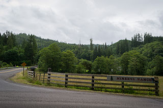
Minerva is an unincorporated community in Lane County, Oregon, United States. It is located about 13 miles (21 km) northeast of Florence near the North Fork Siuslaw River within the Siuslaw National Forest.
Swiss is an unincorporated community in western Nicholas County, West Virginia, United States. Its elevation is 735 ft (224 m).

Wendling is an unincorporated community in Lane County, Oregon, United States, located northeast of Marcola. Wendling's post office operated from 1899 to 1952. The town was named for George X. Wendling, a San Francisco investor, who was the largest investor in Booth-Kelly's expansion into the Mohawk. Wendling was created as a company town for the Booth-Kelly Lumber Company.

Lorane is an unincorporated community in Lane County, Oregon, United States. It is located on Territorial Road about 20 miles (32 km) southwest of Eugene; it is 13 miles (21 km) northwest of Cottage Grove. The community is near the headwaters of the North Fork Siuslaw River in a valley in the foothills of the Central Oregon Coast Range. Local businesses include several wineries, including the King Estate Winery, Chateau Lorane Winery and Iris Hill Winery, and two general stores.
Glenwood is an unincorporated community in Washington County, Oregon, United States, northwest of Forest Grove on Oregon Route 6.

Wilkesboro is an unincorporated community in Washington County, Oregon, United States. It is located on Oregon Route 6, one mile east of Banks.
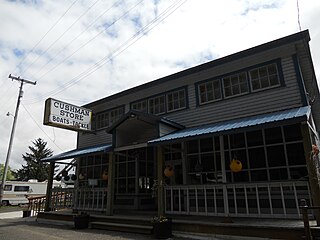
Cushman is an unincorporated community in Lane County, Oregon, United States. It is located on the north bank of the Siuslaw River on Oregon Route 126, between Tiernan and Florence.

Horton is an unincorporated community in Lane County, Oregon, United States. It is about three miles northeast of Blachly, in the Lake Creek valley of the Central Oregon Coast Range.
Linslaw is an unincorporated community in Lane County, Oregon, United States. It is located about eight miles west of Walton on Oregon Route 126 next to the Siuslaw River.
Nonpareil is an unincorporated historic community in Douglas County, Oregon, United States. It is about 8 miles (13 km) east of Sutherlin, near Calapooya Creek. The population of the area was about 202 in 2000. Nonpareil was the birthplace of novelist H. L. Davis.
Tiernan is an unincorporated community in Lane County, Oregon, United States. It is about five miles west of Mapleton on Oregon Route 126 near the Siuslaw River and within the Siuslaw National Forest.
Siltcoos is an unincorporated community in Lane County, Oregon, United States. It is about 13 miles (21 km) south of Florence on the east shore of Siltcoos Lake.
Vaughn is an unincorporated community in Lane County, Oregon, United States. It is located about 4 miles (6.4 km) south of Noti in the foothills of the Central Oregon Coast Range near Noti Creek. Author Ralph Friedman described Vaughn as "a mill in the meadows".
Clifton is an unincorporated community in Clatsop County, Oregon, United States. It is located north of U.S. Route 30, about nine miles northwest of Westport on the south bank of the Columbia River. It is on Clifton Channel across from Tenasillahe Island.
Beaver Hill is an unincorporated community in Coos County, Oregon, United States. It is about 12 miles (19 km) south of the city of Coos Bay, east of U.S. Route 101 and west of Oregon Route 42.

Southport is an unincorporated locale in Coos County, Oregon, United States. It was located along Southport Creek, near where the creek flows into Isthmus Slough, 6.5 miles (10 km) south of the city of Coos Bay, at an elevation of 30 feet. The former community is now a ghost town.
References
- ↑ "Canary". Geographic Names Information System . United States Geological Survey, United States Department of the Interior. November 28, 1980. Retrieved July 30, 2023.
- ↑ Oregon Atlas & Gazetteer (7th ed.). Yarmouth, Maine: DeLorme. 2008. ISBN 978-0-89933-347-2.
- 1 2 3 McArthur, Lewis A.; McArthur, Lewis L. (2003) [1928]. Oregon Geographic Names (7th ed.). Portland, Oregon: Oregon Historical Society Press. p. 155. ISBN 978-0875952772.
- 1 2 3 4 5 Ramstead, David A. (Spring 1988). "Tsiltcoos Lake Post Offices". Lane County Historian. 33 (1). Lane County Historical Society. Retrieved July 30, 2023.
- ↑ "Mountain Fir Buys Donna Mill, Timber". The Eugene Guard . June 21, 1955. Retrieved July 31, 2023.
- 1 2 Friedman, Ralph (1990). In Search of Western Oregon. Caldwell, Idaho: The Caxton Printers, Ltd. pp. 74–76. ISBN 0-87004-332-3.
- ↑ "Schools". Siuslaw Pioneer Museum . Retrieved July 30, 2023.
- ↑ Applebee, Cal (July 21, 2023). "'...Home on the Grange'". Siuslaw News . Retrieved July 30, 2023.
