Walton, Oregon

Last updated
Walton, Oregon
Walton, Oregon.JPG
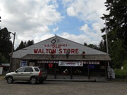
The post office and store at Walton
USA Oregon location map.svg
Red pog.svg
Walton
Usa edcp location map.svg
Red pog.svg
Walton
Coordinates: 44°1′51″N123°35′3″W / 44.03083°N 123.58417°W / 44.03083; -123.58417 Coordinates: 44°1′51″N123°35′3″W / 44.03083°N 123.58417°W / 44.03083; -123.58417
Country United States
State Oregon
County Lane
Time zone UTC-8 (Pacific (PST))
  Summer (DST) UTC-7 (PDT)
ZIP code
97490 [1]
Area code(s) 458 and 541

Walton is an unincorporated community in Lane County, Oregon, United States. It is located halfway between Eugene and Florence on Oregon Route 126.

Construction of Route 126 began in 1881, and after it crossed the Oregon Coast Range near Noti, it followed a tributary of the Siuslaw River named Walton Creek. [2] Walton post office was established in 1884 to serve the settlers along the new route and postmaster James L. Atkinson named it for the stream. [2] The stream was in turn named for Joshua J. Walton, a pioneer lawyer who served as a county judge and regent for the University of Oregon. [2] After the turn of the 19th century, the stream's name was changed to Wildcat Creek. [2]

Related Research Articles

<span class="mw-page-title-main">Marys River (Oregon)</span> River in Oregon, United States

Marys River is a 40-mile (64 km) tributary of the Willamette River in the U.S. state of Oregon. From its source at the confluence of its east and west forks near Summit, it flows generally southeast from the Central Oregon Coast Range to Corvallis.

Idiotville is a ghost town in Tillamook County, Oregon, United States, near the mouth of Idiot Creek on the Wilson River, on the route of Oregon Route 6. Idiotville's elevation is 1,200 feet.

<span class="mw-page-title-main">Elmira, Oregon</span> Unincorporated community in the state of Oregon, United States

Elmira is an unincorporated community in Lane County, Oregon, United States. It is located west of Eugene and north of Veneta and Oregon Route 126, near the Long Tom River and Fern Ridge Reservoir.

<span class="mw-page-title-main">Eagle Creek, Oregon</span> Unincorporated community in the state of Oregon, United States

Eagle Creek is an unincorporated community in Clackamas County, Oregon, United States. It is located seven miles southwest of Sandy, seven miles north of Estacada, and five miles southeast of Carver, at the junction of Oregon Routes 224 and 211, on the Clackamas River.

<span class="mw-page-title-main">Vida, Oregon</span> Former unincorporated community in Oregon, United States

Vida is an unincorporated community in Lane County, Oregon, United States. It is located on Oregon Route 126 and the McKenzie River.

<span class="mw-page-title-main">Days Creek, Oregon</span> Unincorporated community in the state of Oregon, United States

Days Creek is an unincorporated community and census-designated place in Douglas County, Oregon, United States. At the 2010 census it had a population of 272.

<span class="mw-page-title-main">Deadwood, Oregon</span> Unincorporated community in the state of Oregon, United States

Deadwood is an unincorporated community in Lane County, Oregon, United States. It is located on Oregon Route 36, in the Oregon Coast Range.

<span class="mw-page-title-main">Finn Rock, Oregon</span> Unincorporated community in the state of Oregon, United States

Finn Rock is an unincorporated community in Lane County, Oregon, United States. It is located on Oregon Route 126 and the McKenzie River, between the communities of Nimrod and Blue River, in the Willamette National Forest.

<span class="mw-page-title-main">Jasper, Oregon</span> Unincorporated community in the state of Oregon, United States

Jasper is an unincorporated community in Lane County, Oregon, United States. It is southeast of Springfield on Oregon Route 222, at the confluence of Hills Creek and the Middle Fork Willamette River.

<span class="mw-page-title-main">Gales Creek, Oregon</span> Unincorporated community in the state of Oregon, United States

Gales Creek is an unincorporated community in Washington County, Oregon, United States on Oregon Route 8 northwest of Forest Grove in the foothills of the Oregon Coast Range.

<span class="mw-page-title-main">New Pine Creek, Oregon</span> Unincorporated community in the state of Oregon, United States

New Pine Creek is a census-designated place and unincorporated community in Lake County, Oregon, United States. As of the 2010 census, it had a population of 120. it has a post office with a ZIP code 97635. New Pine Creek lies on U.S. Route 395 at the Oregon–California border, just north of New Pine Creek, California, and east of Goose Lake.

<span class="mw-page-title-main">Service Creek, Oregon</span> Unincorporated community in the state of Oregon, United States

Service Creek is an unincorporated community in Wheeler County, in the U.S. state of Oregon. Service Creek lies on Oregon Route 19 near its intersection with Oregon Route 207. It is also near the mouth of a stream, Service Creek, formerly Sarvis Creek, that empties into the John Day River.

<span class="mw-page-title-main">Blue River (Oregon)</span> Tributary of the McKenzie River in Linn and Lane counties in the U.S. state of Oregon

Blue River is a tributary of the McKenzie River in Linn and Lane counties in the U.S. state of Oregon. From its source at the confluence of Mann and Wolf creeks in the Cascade Range, it flows generally southwest to join the McKenzie near the community of Blue River. Saddle Dam and Blue River Dam block the river about 2 miles (3 km) from its mouth to form Blue River Reservoir, a multipurpose impoundment built in 1968 by the United States Army Corps of Engineers.

<span class="mw-page-title-main">Union Creek, Oregon</span> Unincorporated community in the state of Oregon, United States

Union Creek is an unincorporated community in Jackson County in the U.S. state of Oregon. It is located along Union Creek and Oregon Route 62, about 15 miles (24 km) from Crater Lake National Park. The community is home to the Union Creek Historic District, which has been listed on the National Register of Historic Places since 1980.

Linslaw is an unincorporated community in Lane County, Oregon, United States. It is located about eight miles west of Walton on Oregon Route 126 next to the Siuslaw River.

<span class="mw-page-title-main">Whychus Creek</span> River in Oregon, United States

Whychus Creek is a tributary of the Deschutes River in Deschutes and Jefferson counties in the U.S. state of Oregon. Formerly named Squaw Creek, considered derogatory in the 21st century, it was renamed in 2006. Explorer John C. Frémont camped along the stream in 1843 but did not identify it by name. Robert S. Williamson, a surveyor who camped there in 1855, said its Indian name was Why-chus.

<span class="mw-page-title-main">Wildcat Creek (Siuslaw River tributary)</span> River in Oregon, United States

Wildcat Creek is a 16-mile-long (26 km) creek in Lane County, Oregon, United States within the Siuslaw National Forest. The creek empties into the Siuslaw River at Austa on Oregon Route 126.

<span class="mw-page-title-main">Sisters State Park</span> State park in Oregon, United States

Sisters State Park is a state park located at the southeast side of the town of Sisters in Deschutes County, Oregon, United States. The park property is bisected by U.S. Route 20 and Oregon Route 126, creating three separate parcels. The park covers 28 acres (11 ha) of undeveloped forest land along Whychus Creek. It is adjacent to two developed city parks that were once part of the state park. Sisters State Park is administered by the Oregon Parks and Recreation Department.

Foots Creek is an unincorporated community and census-designated place (CDP) in Jackson County, in the U.S. state of Oregon. It lies along Oregon Route 99 near the mouth of Foots Creek, where it empties into the Rogue River. Interstate 5 and Valley of the Rogue State Park are on the side of the river opposite Foots Creek.

Beech Creek is an unincorporated community in Grant County, Oregon. It is located at the intersection of U.S. Route 395 and County Road 27.

References

  1. "Walton ZIP Code". zipdatamaps.com. 2022. Retrieved November 11, 2022.
  2. 1 2 3 4 McArthur, Lewis A.; Lewis L. McArthur (2003) [1928]. Oregon Geographic Names (Seventh ed.). Portland, Oregon: Oregon Historical Society Press. pp. 1006–1007. ISBN   0-87595-277-1.