Finn Rock, Oregon

Last updated
Finn Rock, Oregon
Finn Rock closed restaurant - Finn Rock Oregon.jpg
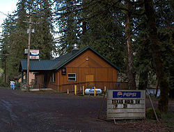
Closed restaurant in Finn Rock
USA Oregon location map.svg
Red pog.svg
Finn Rock
Usa edcp location map.svg
Red pog.svg
Finn Rock
Coordinates: 44°7′45″N122°22′54″W / 44.12917°N 122.38167°W / 44.12917; -122.38167 Coordinates: 44°7′45″N122°22′54″W / 44.12917°N 122.38167°W / 44.12917; -122.38167
Country United States
State Oregon
County Lane
Time zone UTC-8 (Pacific (PST))
  Summer (DST) UTC-7 (PDT)
ZIP code
97488
Area code(s) 458 and 541

Finn Rock is an unincorporated community in Lane County, Oregon, United States. It is located on Oregon Route 126 and the McKenzie River, between the communities of Nimrod and Blue River, in the Willamette National Forest.

Contents

Finn Rock was once a logging community and is named after an unusual rock formation on Route 126 near the mouth of Finn Creek. [1] [2] Although the rock resembles a shark's fin, the rock was named for Benjamin Franklin Finn, an early settler of the area. [2] [3] Ben Finn was known as "the biggest liar on the McKenzie River", and claimed to be the inspiration for Mark Twain's Huckleberry Finn. [3] [4] Finn Rock post office operated from 1947 until 1961. [2] The 1929 general store building that also served as the post office is now a restaurant. [1]

Finn Rock Rest Area, formerly known as Howard Morton State Park, is located near Finn Rock. McKenzie High School is located in Finn Rock.

Notable residents

Related Research Articles

McKenzie River (Oregon) Mckenzie Blue River

The McKenzie River is a 90-mile (145 km) tributary of the Willamette River in western Oregon in the United States. It drains part of the Cascade Range east of Eugene and flows westward into the southernmost end of the Willamette Valley. It is named for Donald McKenzie, a Scottish Canadian fur trader who explored parts of the Pacific Northwest for the Pacific Fur Company in the early 19th century. As of the 21st century, six large dams have been built on the McKenzie and its tributaries.

Mapleton, Oregon Unincorporated community in the State of Oregon, United States

Mapleton is an unincorporated community in Lane County, Oregon, United States. It is located on Oregon Route 126 and the Siuslaw River, 45 miles (72 km) west of Eugene and 15 miles (24 km) east of Florence. It is also the western terminus of Oregon Route 36. As of the 2000 census, Mapleton had a total population of 918.

Noti, Oregon Unincorporated community in the State of Oregon, United States

Noti is an unincorporated community in Lane County, Oregon, United States, located in the foothills of the Central Oregon Coast Range between Eugene and Florence. Per the 2000 census, Noti had a total population of 699.

Santiam Pass Mountain Pass in Oregon, United States

Santiam Pass is a 4,817-foot (1,468 m) mountain pass in the Cascade Range in central Oregon in the United States. It is located on the border between Linn and Jefferson counties, about 18 mi (29 km) northwest of Sisters, between the prominent volcanic horns of Three Fingered Jack to the north and Mount Washington to the south. Several other smaller volcanoes, including cinder cones and tuyas, are found near the summit of the pass. U.S. Route 20 connects eastern Oregon with the valley of the Santiam River on the west via Santiam Pass. One of the 19 or 20 lakes by the name of Lost Lake is located beside the highway just west of Santiam Pass. The pass may be approached from the west by three distinct routes:

Elmira, Oregon Unincorporated community in the State of Oregon, United States

Elmira is an unincorporated community in Lane County, Oregon, United States. It is located west of Eugene and north of Veneta and Oregon Route 126, near the Long Tom River and Fern Ridge Reservoir.

Nimrod, Oregon Unincorporated community in the State of Oregon, United States

Nimrod is an unincorporated community in Lane County, Oregon, United States, on the McKenzie River. It is located along Oregon Route 126, between Vida and Blue River, 35 miles (56 km) east of Eugene, in the Willamette National Forest. As of 2003, its population was roughly 190. Nimrod is the site of a former ferry that crossed the McKenzie. Nimrod is served by the Vida post office, zip code 97488.

Pratum, Oregon Unincorporated community in the State of Oregon, United States

Pratum is an unincorporated community in Marion County, Oregon, United States. It is located northeast of Salem on Howell Prairie near the Pudding River. Pratum is Latin for "meadow". The community was settled in the late 19th century by a group of Mennonites, many of them of Swiss extraction. A branch of the narrow-gauge Oregonian Railway was built through the area in about 1880, and the station there was called "East Side Junction". The railway was eventually converted to standard gauge, and is still in use today by the Willamette Valley Railway. In 1895, the station was renamed "Enger" by a Mr. Larson, who opened the first store there. "Enger" was confused with Eugene, however, and the name of the station changed to "Pratum" in 1898. Pratum post office was established in 1887, and was originally called "Switzerland", then "Enger" and finally "Pratum" in 1898, matching the railroad station. The post office ran until 1964. Pratum School, built in 1928 and part of the Silver Falls School District, is still operating.

Vida, Oregon Former unincorporated community in Oregon, United States

Vida is an unincorporated community in Lane County, Oregon, United States. It is located on Oregon Route 126 and the McKenzie River.

Blue River, Oregon Unincorporated community in the State of Oregon, United States

Blue River is an unincorporated community in Lane County, Oregon, United States. It is located on Oregon Route 126 along the McKenzie River, between the communities of Finn Rock and Rainbow. It is in the Willamette National Forest, where the Blue River empties into the McKenzie. The community was named after the Blue River, which was named for the striking blue color that apparently comes from its rocky bed. Five miles northeast of the community, a dam on the Blue River forms the Blue River Reservoir.

Walterville, Oregon Unincorporated community in the State of Oregon, United States

Walterville is an unincorporated community in Lane County, Oregon, United States. It is located six miles (9.7 km) east of Springfield on Oregon Route 126 near the McKenzie River.

Walton, Oregon Unincorporated community in the State of Oregon, United States

Walton is an unincorporated community in Lane County, Oregon, United States. It is located halfway between Eugene and Florence on Oregon Route 126.

Leaburg, Oregon Unincorporated community in the State of Oregon, United States

Leaburg is an unincorporated community in Lane County, Oregon, United States located on the McKenzie River and Oregon Route 126 east of Walterville and west of Vida.

Rock Point, Oregon Unincorporated community in the State of Oregon, United States

Rock Point is an unincorporated community in Jackson County, Oregon, United States. Rock Point lies just north of an I-5 and Oregon Route 99 interchange along the Rogue River between the cities of Rogue River and Gold Hill.

Rainbow, Oregon Unincorporated community in the State of Oregon, United States

Rainbow is an unincorporated community in Lane County, Oregon, United States. It lies off Oregon Route 126, northeast of Eugene. Rainbow's elevation is 1,211 feet (369 m). A post office was established on July 1, 1924, and closed August 31, 1937. The post office got its name from the rainbow trout that swim in the McKenzie River.

Blue River (Oregon) Tributary of the McKenzie River in Linn and Lane counties in the U.S. state of Oregon

Blue River is a tributary of the McKenzie River in Linn and Lane counties in the U.S. state of Oregon. From its source at the confluence of Mann and Wolf creeks in the Cascade Range, it flows generally southwest to join the McKenzie near the community of Blue River. Saddle Dam and Blue River Dam block the river about 2 miles (3 km) from its mouth to form Blue River Reservoir, a multipurpose impoundment built in 1968 by the United States Army Corps of Engineers.

Hilgard, Oregon Unincorporated community in the State of Oregon, United States

Hilgard is an unincorporated community in Union County, Oregon, United States, at the junction of Oregon Route 244 with Interstate 84/U.S. Route 30, near the Grande Ronde River. It is also the site of a junction (wye) of the Union Pacific Railroad. Hilgard Junction State Recreation Area is across the river from the community.

Linslaw is an unincorporated community in Lane County, Oregon, United States. It is located about eight miles west of Walton on Oregon Route 126 next to the Siuslaw River.

Deerhorn, Oregon Unincorporated community in the State of Oregon, United States

Deerhorn is an unincorporated community in Lane County, Oregon, United States. It is about 4 miles (6 km) west of Leaburg on Oregon Route 126 in the McKenzie River valley.

Tiernan is an unincorporated community in Lane County, Oregon, United States. It is about five miles west of Mapleton on Oregon Route 126 near the Siuslaw River and within the Siuslaw National Forest.

Blalock was an unincorporated community located in the Columbia River Gorge in Gilliam County, Oregon, United States. The town displaced a Native American settlement originally named Táwash. Blalock was located about 7 miles (11 km) west of Arlington on Interstate 84/U.S. Route 30 at the mouth of Blalock Canyon. Blalock is still the name of a station on the Union Pacific Railroad.

References

  1. 1 2 "Where to dine that's down by the river". The Register-Guard . Eugene, Oregon. August 8, 2006. p. E3. Retrieved June 26, 2013.
  2. 1 2 3 McArthur, Lewis A.; McArthur, Lewis L. (2003) [1928]. Oregon Geographic Names (7th ed.). Portland, Oregon: Oregon Historical Society Press. p. 353. ISBN   978-0875952772.
  3. 1 2 Western Literature Association (1987). A Literary History of the American West (full text) (PDF). Fort Worth, Texas: Texas Christian University Press. ISBN   0-87565-021-X.
  4. "Nimrod to Blue River". McKenzie River Reflections. Archived from the original on February 7, 2012.
  5. Wadsworth, Lois (April 25, 2002). "Between Two Worlds". Eugene Weekly . Archived from the original on June 17, 2007. Retrieved May 6, 2007.