A covered bridge is a timber-truss bridge with a roof, decking, and siding, which in most covered bridges create an almost complete enclosure. The purpose of the covering is to protect the wooden structural members from the weather. Uncovered wooden bridges typically have a lifespan of only 20 years because of the effects of rain and sun, but a covered bridge could last over 100 years. In the United States, only about 1 in 10 survived the 20th century. The relatively small number of surviving bridges is due to deliberate replacement, neglect, and the high cost of restoration.

The Pont Saint-Bénézet, also known as the Pont d'Avignon, was a medieval bridge across the Rhône in the town of Avignon, in southern France. Only four arches survive.
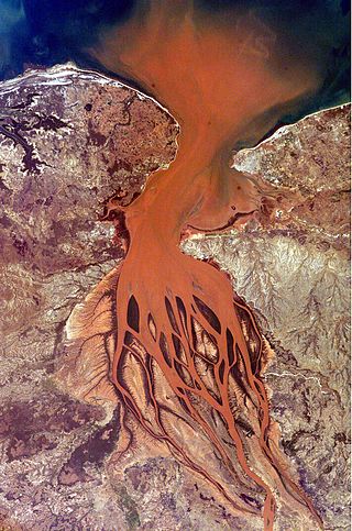
Bombetoka Bay is a bay on the northwestern coast of Madagascar near the city of Mahajanga, where the Betsiboka River flows into the Mozambique Channel. Numerous islands and sandbars have formed in the estuary from the large amount of sediment carried in by the Betsiboka River and have been shaped by the flow of the river and the push and pull of tides.

Ankarafantsika National Park is a national park near Andranofasika in the Boeny Region of Madagascar. The closest city is Majunga 115 kilometres (71 mi) north of the park. Ankarafantsika is mostly tropical in climate type. The Sakalava people are the predominant ethnic group living and farming here. The greater big-footed mouse lives in the park and is not known anywhere else.

Betsiboka River is a 525-kilometre (326 mi) long river in central-north Madagascar. It flows northwestward and empties to Bombetoka Bay, forming a large delta. It originates to the east of Antananarivo. The river is surrounded in mangroves. The river is distinctive for its red-coloured water, which is caused by river sediments. The river carries an enormous amount of reddish-orange silt to the sea. Much of this silt is deposited at the mouth of the river or in the bay.

Analamanga is a region in central Madagascar, containing the capital Antananarivo and its surrounding metropolitan area. The region has an area of 17,488 square kilometres, and had a population of 4,325.226 in 2018.

Bongolava is a region in central-western Madagascar. The capital of the region is Tsiroanomandidy. It had a population of 674,474 in 2018.

Maevatanana is an urban municipality in Madagascar. The city is in the central-north part of the island, at the Ikopa River, and is connected by the national road RN 4 to Antananarivo and Mahajanga. The altitude is low and as it is located far from the coast, temperatures tend to be high. The city belongs to the district of Maevatanana, which is a part of Betsiboka Region. Maevatanana is the capital of the Betsiboka region, and the population of the commune was estimated to be approximately 24,000 in 2001 commune census.
Marovoay is an urban municipality in north-western Madagascar. It belongs to the district of Marovoay, which is a part of Boeny Region. The population of the commune was estimated to be approximately 65,000 in 2001 commune census.
The Ikopa River is the second longest waterway in Madagascar and passes through the capital, Antananarivo. It is the largest tributary of the Betsiboka River. It is formed by the Varahina-North and Varahina-South Rivers.

Boeny is a region in northwestern Madagascar. It borders Sofia Region to the northeast, Betsiboka to the south and Melaky to the southwest. The capital of the region is Mahajanga, and the population was 931,171 in 2018. The area of Boeny is 31,046 km2 (11,987 sq mi).
Betsiboka is a region of Madagascar. It borders Boeny Region in north, Sofia in northeast, Alaotra-Mangoro in east, Analamanga and Bongolava in south and Melaky in west. The capital of the region is Maevatanana. Until 2009 Betsiboka belonged to Mahajanga Province. The population was 394,561 in 2018 within the area of 30,025 km2 (11,593 sq mi). Betsiboka is one of the least densely populated regions in Madagascar.
Madirovalo is a rural municipality in Madagascar. It belongs to the district of Ambato-Boeni, which is a part of Boeny Region. The population of the commune was estimated to be approximately 66,000 in 2001.

Marovoay is a district in northwestern Madagascar. It is a part of Boeny Region and borders the districts of Mahajanga II in north, Boriziny and Mampikony in east, Ambato-Boeni in south and Mitsinjo in west. The area is 3,804 km2 (1,469 sq mi) and the population was estimated to be 182,742 in 2013.
Maevatanana II is a rural municipality in Madagascar. It covers the villages around the town of Maevatanana and belongs to the district of Maevatanana, which is a part of Betsiboka Region. The population of the commune was estimated to be approximately 16,000 in 2001 commune census.