
The Cathedral and Metropolitical Church of Saint Peter in York, commonly known as York Minster, is the cathedral of York, North Yorkshire, England, and is one of the largest of its kind in Northern Europe. The minster is the seat of the Archbishop of York, the third-highest office of the Church of England, and is the mother church for the Diocese of York and the Province of York. It is run by a dean and chapter, under the Dean of York. The title "minster" is attributed to churches established in the Anglo-Saxon period as missionary teaching churches, and serves now as an honorific title; the word Metropolitical in the formal name refers to the Archbishop of York's role as the Metropolitan bishop of the Province of York. Services in the minster are sometimes regarded as on the High Church or Anglo-Catholic end of the Anglican continuum.

The East Riding of Yorkshire, or simply East Riding or East Yorkshire, is a ceremonial county in Northern England. It borders North Yorkshire to the north and west, South Yorkshire to the south-west, and Lincolnshire to the south. It is also a non-metropolitan county for local government purposes. The coastal towns of Bridlington and Hornsea are popular with tourists from inland areas, and the port city of Kingston upon Hull is an economic, transport and tourism centre which also receives much sea freight from around the world. The current East Riding of Yorkshire came into existence in 1996 after the abolition of the County of Humberside. The county's administration is in the ancient market town of Beverley. The landscape is mainly rural, consisting of rolling hills, valleys and flat plains with many small villages and some towns scattered amid the Yorkshire Wolds. Major settlements include Kingston upon Hull, Beverley, Bridlington and Goole. At the 2011 United Kingdom census, its population was 334,179.

In architecture, a folly is a building constructed primarily for decoration, but suggesting through its appearance some other purpose, or of such extravagant appearance that it transcends the range of usual garden buildings.
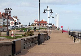
Hornsea is a seaside town and civil parish in the East Riding of Yorkshire, England. The settlement dates to at least the early medieval period. The town was expanded in the Victorian era with the coming of the Hull and Hornsea Railway in 1864. In the First World War the Mere was briefly the site of RNAS Hornsea Mere, a seaplane base. During the Second World War the town and beach was heavily fortified against invasion.

Perrott's Folly, grid reference SP047862, also known as The Monument, or The Observatory, is a 29-metre (96-foot) tall tower, built in 1758. It is a Grade II* listed building in the Edgbaston area of Birmingham, United Kingdom.

Wilberforce House is a British historic house museum, part of the Museums Quarter of Kingston-upon-Hull. It is the birthplace of social reformer William Wilberforce (1759–1833), who used his time as a member of Parliament to work for the abolition of slavery throughout the British Empire. Like the nearby Blaydes House and Maister House, also on the High Street, the Grade I listed building was formerly a merchant's house with access to quayside on the River Hull.

Cottingham is a large village and civil parish in the East Riding of Yorkshire, England with average affluence. It lies 3+1⁄2 miles (5.6 km) north-west of the centre of Kingston upon Hull, and 6.2 miles (10.0 km) south-east of Beverley on the eastern edge of the Yorkshire Wolds. It has two main shopping streets, Hallgate and King Street, which cross each other near the Church of Saint Mary the Virgin, and a market square called Market Green. Cottingham had a population of 17,164 residents in 2011 making it larger by area and population than many towns. However, it is one of the villages claiming to be the largest village in England.

Hull Paragon Interchange is a transport interchange providing rail, bus and coach services located in the city centre of Kingston upon Hull, England. The G.T. Andrews-designed station was originally named Paragon Station, and together with the adjoining Station Hotel, it opened in 1847 as the new Hull terminus for the growing traffic of the York and North Midland (Y&NMR) leased to the Hull and Selby Railway (H&S). As well as trains to the west, the station was the terminus of the Y&NMR and H&S railway's Hull to Scarborough Line. From the 1860s the station also became the terminus of the Hull and Holderness and Hull and Hornsea railways.

Cuthbert Brodrick FRIBA was a British architect, whose most famous building is Leeds Town Hall.

Knaresborough railway station is a Grade II listed station serving the town of Knaresborough in North Yorkshire, England. It is located on the Harrogate Line 16.75 miles (27 km) west of York and is operated by Northern Trains, who provide all passenger train services.

The Grand Hotel is a large hotel in Scarborough, North Yorkshire, England, overlooking the town's South Bay. It is a Grade II* listed building and owned by Britannia Hotels. At the time of its grand opening in 1867, it was the largest hotel and the largest brick structure in Europe.
Catwick is a village and civil parish in the East Riding of Yorkshire, England. It is situated approximately 7.5 miles (12 km) north-east of Beverley town centre and 5 miles (8 km) west of Hornsea town centre. It lies on the A1035 road from Leven to Hornsea.

Wainhouse Tower is a folly in the parish of King Cross, on the south west side of Halifax, Calderdale, West Yorkshire, in England. At 275 feet (84 m), it is the tallest structure in Calderdale and the tallest folly in the world, and was erected in the four years between 1871 and 1875. The main shaft is octagonal in shape and it has a square base and 369 steps leading to the first of two viewing platforms which is open to the public, and a total of 405 to the top viewing platform which is usually closed to the public. The tower is open to the public during bank holidays, and is a Grade II* listed building.

Skidby Windmill is a Grade II* listed windmill at Skidby near Beverley, in the East Riding of Yorkshire, England.
Sutton-on-Hull is a suburb of the city of Kingston upon Hull, in the ceremonial county of the East Riding of Yorkshire, England. It is located 3 miles (4.8 km) north east of the city centre and has the B1237 road running through it which connects the A165 road with the A1033.

Newland is a suburb of Kingston upon Hull, East Riding of Yorkshire, England, in the north-west of the city, a former village on the Hull to Beverley turnpike.

The Yorkshire Coast runs from the Tees estuary to the Humber estuary, on the east coast of England. The cliffs at Boulby are the highest on the east coast of England, rising to 660 feet (200 m) above the sea level.

RNAS Hornsea Mere,, was a Royal Naval Air Service seaplane base located on Hornsea Mere, in the East Riding of Yorkshire, England. The mere was used for seaplanes because it was close to the sea and because its still water made it easier to launch the planes. Initially used as a relief site, the base became a full station in 1918, and was vacated in 1919. Many of the original buildings and earthworks survive.
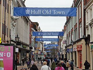
Whitefriargate is a pedestrianised street in the Old Town area of Kingston upon Hull, in the East Riding of Yorkshire, England. During the 20th century, it was one of the main shopping streets in the city centre, but some of the major stores have closed down, which has been attributed to out of town shopping centres. However, the Street still provides a useful link to and from the old town of Hull.
