
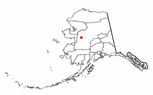
Yukon–Koyukuk Census Area is a census area in the U.S. state of Alaska. As of the 2020 census, the population was 5,343, down from 5,588 in 2010. With an area of 147,842.51 sq mi (382,910.3 km2), it is the largest of any county or county-equivalent in the United States, or slightly larger than the entire state of Montana. It is part of the unorganized borough of Alaska and therefore has no borough seat. Its largest communities are the cities of Galena, in the west, and Fort Yukon, in the northeast.

Alatna is a census-designated place (CDP) in the Yukon-Koyukuk Census Area of the Unorganized Borough in the U.S. state of Alaska. The population was 35 at the 2020 census.

Allakaket is a second class city in the Yukon-Koyukuk Census Area of the Unorganized Borough of the U.S. state of Alaska. The population was 177 at the 2020 census.

Bettles is a city in Yukon-Koyukuk Census Area, Alaska, United States. It is near Gates of the Arctic National Park and Preserve. The population was 23 at the 2020 census, up from 12 in 2010. It is the second smallest incorporated city in the state.
Evansville is a census-designated place (CDP) in Yukon-Koyukuk Census Area, Alaska, United States. The population was 15 at the 2010 census, down from 28 in 2000. The community is adjacent to Bettles. The community is named after Wilford Evans, Sr, who took part in the founding of Bettles Lodge.
Kaltag(KAL-tag) is a city and village in Yukon-Koyukuk Census Area, Alaska, United States. At the 2010 census the population was 190, down from 230 in 2000.
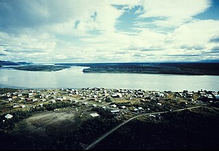
Koyukuk is a city in Yukon-Koyukuk Census Area, Alaska, United States. At the 2010 census the population was 96, down from 101 in 2000.

Nulato is a city in Yukon-Koyukuk Census Area, Alaska, United States. At the 2020 census, the population was 239.

Gates of the Arctic National Park and Preserve is a national park of the United States that protects portions of the Brooks Range in northern Alaska. The park is the northernmost national park in the United States, situated entirely north of the Arctic Circle. The area of the park and preserve is the second largest in the U.S. at 8,472,506 acres ; the National Park portion is the second largest in the U.S., after the National Park portion of Wrangell–St. Elias National Park and Preserve.

The Koyukuk River is a 425-mile (684 km) tributary of the Yukon River, in the U.S. state of Alaska. It is the last major tributary entering the Yukon before the larger river empties into the Bering Sea.

Bettles Airport is a state-owned public-use airport located in Bettles, a city in the Yukon-Koyukuk Census Area of the U.S. state of Alaska.

Prospect Creek is a very small settlement approximately 180 miles (290 km) north of present-day Fairbanks and 25 miles (40 km) southeast of present-day Bettles, Alaska. Years ago it was home to numerous mining expeditions and the camp for the building of the Trans-Alaska Pipeline System (TAPS). Today, it is the location of Pump Station 5 of the TAPS. Prospect Creek is also home to the United States record for lowest temperature. On January 23, 1971, the record low temperature of −79.8 °F (−62.1 °C) was recorded. Wildlife can be found there even with its extreme changes in temperature; local fauna include anything from black and brown bears to bald eagles. The elevation of Prospect Creek is 643 feet (196 m) above sea level. Nearby Moore Creek is widely known for its gold and quartz mining and sits alongside Prospect Creek in Alaska’s Innoko Mining District. The Innoko Mining District is famous for its findings of large quartz.
John Bremner (1833–1887) was a prospector and early explorer of Alaska.
Bettles Lodge, located a few miles from Bettles, Alaska on the south bank of the Koyukuk River in the Brooks Range, was built in 1951 by Warren Killen and Wilfred Evans. It has served as a hotel and restaurant and was listed on the National Register of Historic Places in 1997. The listing included two contributing buildings: a first lodge built in 1948 and a second built in 1951. The lodge buildings are significant because it is the oldest in the community, and it served as an air transportation hub for the northern interior area of Alaska.

The Middle Fork Koyukuk River is a 62-mile (100 km) tributary of the Koyukuk River in the U.S. state of Alaska. Formed by the confluence of the Bettles and Dietrich rivers near Wiseman on the southern flank of the Brooks Range, the Middle Fork flows generally southwest to its confluence with the North Fork Koyukuk River, with which it forms the main stem of the Koyukuk.

Yukon–Koyukuk School District (YKSD) is a school district headquartered in College, a census-designated place in Fairbanks North Star Borough, Alaska. It serves the Yukon–Koyukuk area.
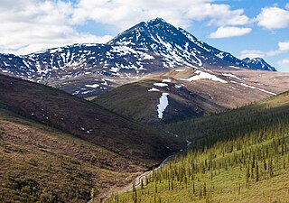
Poss Mountain is a prominent 6,180-foot mountain summit located in the Philip Smith Mountains of the Brooks Range, in the U.S. state of Alaska. The peak is situated 80 miles north of the Arctic Circle, five miles east of Dalton Highway, 11.3 mi (18 km) south of Sukakpak Mountain, and 190 mi (306 km) north-northwest of Fairbanks. The peak was named about 1930 by wilderness activist Robert Marshall after "Poss" Postlethwaite, an early and old gold prospector in this area around Wiseman. Robert Marshall described the then 78-year-old Postlethwaite as "the oldest man in the Koyukuk," having spent 32 winters in the area. The name was officially adopted in 1932 by the U.S. Board on Geographic Names. The Poss Mountain Research Natural Area was designated in 1991 to protect natural mineral licks and lambing habitat for Dall sheep. Precipitation runoff from the mountain drains into tributaries of the Middle and South Forks of Koyukuk River.

The Wild River is a river, about 63 miles (101 km) long, in the U.S. state of Alaska whose headwaters are found in Wild Lake at the foot of Tobin Mountain with a mouth emptying into the Koyukuk River near Bettles, Alaska. The river flows through the southern edge of the Brooks Range and out into the plains of the Yukon River System of north central Alaska and the Kanuti Flats.

The Dietrich River is a 35 miles (56 km) long braided river in the Yukon-Koyukuk Census Area of Alaska. The headwaters originate in the Brooks Range. It flows south to join the Bettles River and to form the Middle Fork Koyukuk River.

Gordon Charles Bettles was a Canadian-American fur trader, shopkeeper, prospector, and newspaperman active in 19th century Interior Alaska. He established the trading post that would become Bettles, Alaska. He referred to himself as the "Rat-skin-and-bean trader of the North".

